Tropical Depression Two continues drift in Gulf of Mexico at cusp of tropical storm strength
Tropical Depression Two formed in the Gulf of Mexico on Thursday afternoon. With its proximity to Florida, Tropical Depression Two will continue to create a flash flood threat for the state due to ongoing showers and thunderstorms associated with the tropical depression.
Tropical Depression Two spins in Gulf of Mexico amid slow drift to the south
The FOX Weather Center is keeping a close eye on Tropical Depression Two as it meanders in the Gulf of Mexico, eventually adding moisture to thunderstorms already in the forecast for Florida.
Tropical Depression Two formed in the Gulf of Mexico on Thursday afternoon, arriving just as the hurricane season started on June 1.
The Hurricane Hunters flew through the tropical depression on Thursday afternoon and found maximum sustained winds of 35 mph. A tropical depression is a cyclone with maximum sustained surface winds of 38 mph or less.
Despite earlier signs Thursday evening that Tropical Depression Two could strengthen to become a tropical storm, the latest forecasts from the National Hurricane Center Friday morning now suggest that further strengthening is unlikely as the storm encounters greater atmospheric wind shear and drier air.
WHAT’S THE DIFFERENCE BETWEEN A TROPICAL DEPRESSION VS. TROPICAL STORM VS. HURRICANE?
"It appears the window of opportunity for the cyclone to strengthen is closing, or has already closed," NHC forecasters wrote in their 5 a.m. ET Friday forecast update. Forecasters believe the tropical depression will weaken into Friday evening, and dissipate into a remnant low Saturday.
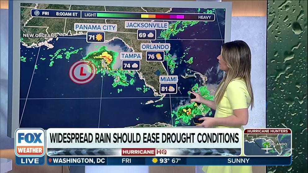
The tropical depression isn't expected to have any direct impacts on the U.S. as its expected track will stay well west of Florida. But the storm will help enhance thunderstorms bringing heavy rains to parts of Florida, especially southern Florida, through the weekend. Flood Watches are in effect.
Hurricane Hunters are taking additional flights into the storm on Friday and Saturday to gather more information. If they find maximum sustained winds of 39 mph or greater, the storm would become Tropical Storm Arlene.
The NHC previously dubbed this disturbance Invest 91L on Wednesday afternoon. An invest is simply a designation used by the NHC to identify an area of weather that is being investigated for possible tropical development.
Where is Tropical Depression Two?

(FOX Weather)
Tropical Depression Two is currently located in the northeastern Gulf of Mexico, about 270 miles west-northwest of Fort Myers, Florida. It's drifting south at only 5 mph.
The tropical depression is expected to spin off to the south and eventually to the southeast and brush the coast of Cuba before turning to the northeast between Cuba and South Florida.
What are the impacts of Tropical Depression Two?

(FOX Weather)
Tropical Depression Two's track is expected to keep the storm offshore with no direct U.S. impacts. But with its proximity to Florida, Tropical Depression Two will continue to enhance a flash flood threat for parts of the state due to ongoing showers and thunderstorms associated with the additional moisture.
"Whether we see the storm strengthen to (Tropical Storm) Arlene or not, we’re not going to see a direct landfall to this system," said FOX Weather Meteorologist Britta Merwin. "(But) it’s going to be close enough to add a lot of tropical moisture (to Florida). And tropical moisture leads to one thing, and that’s a lot of rain."
Flood Watches that will remain through at least Friday afternoon are in effect for several areas of South Florida. Forecast rainfall totals are around 1-4 inches in southern Florida, with isolated aras reaching as much as 5 inches.
What is the forecast for Tropical Depression Two?

(FOX Weather)
As mentioned earlier, Tropical Depression Two is not expected to strengthen into a hurricane nor tropical storm.
HERE ARE THE NAMES YOU’LL SEE DURING THE 2023 ATLANTIC HURRICANE SEASON
The National Hurricane Center said Tropical Depression Two will continue spinning south in the Gulf before eventually dying out into a remnant low pressure area as it nears western Cuba.
"This system is going to be running into a lot of dry air," Merwin said. "(The storm is moving) into a pocket of almost desert-like air that’s going to choke off the system."
No coastal watches or warnings are expected from this tropical depression.
Why is this storm named Tropical Depression Two and not Tropical Depression One?
Even though the hurricane season officially started on June 1, the National Hurricane Center says the first storm of 2023 hurricane season formed in January.
HERE’S WHY THE ATLANTIC HURRICANE SEASON RUNS FROM JUNE TO NOVEMBER
The National Hurricane Center said that after a reassessment months after, forecasters found that the subtropical storm was located about 300 miles north of Bermuda on Jan. 16 and determined it should be designated a subtropical storm.
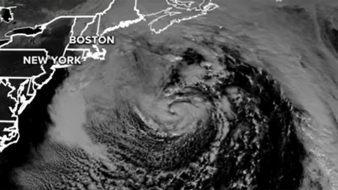
A subtropical storm is seen on satellite in January 2023 as it spins through the North Atlantic Ocean.
(FOX Weather)
The January storm has since been cataloged as the first tropical event of the season, giving the current storm in the Gulf the name of the second.
This is a developing story. Check back with Hurricane HQ on FOX Weather for frequent updates.