Invest 97L likely to become Tropical Storm Erin soon as new area to watch emerges in Atlantic
The NHC has already upped the odds of development for Invest 97L to a high chance over the next few days.

Tropical Depression Five likely to form soon as new area to watch for development emerges in Atlantic
The development chances for Invest 97L are continuing to increase, and forecasters now say Tropical Depression Five or Tropical Storm Erin could form as soon as Monday. FOX Weather Meteorologists Stephen Morgan and Marissa Torres have the latest forecast on Aug. 11, 2025.
As of 11:00 AM ET on Monday, Tropical Storm Erin formed in the Atlantic from Invest 97L. It is expected to become the season's first major hurricane. Continuous coverage of Tropical Storm Erin has moved here.
MIAMI – A new area to watch for tropical development has emerged in the Atlantic Ocean as forecasters continue to monitor Invest 97L, which is expected to become a tropical depression or Tropical Storm Erin soon.
The National Hurricane Center (NHC) has been continuously increasing the development chances for Invest 97L, and did so again with the latest update on Monday morning.

(FOX Weather)
"Shower and thunderstorm activity has persisted and continues to sow signs of organization with a well-defined area of low pressure located just to the west of the Cabo Verde Islands," the NHC said in its Monday morning update. "If these structural trends continue, the system is likely to become a tropical depression or tropical storm, possibly as soon as later this morning."
An "invest" is a naming convention used by the National Hurricane Center to identify areas they are investigating for possible development into a tropical depression or tropical storm within the next seven days.
The designation allows the agency to run specialized computer forecast models to track the area's potential storm development.
The NHC said that locally heavy rainfall and gusty winds are expected to continue across portions of the Cabo Verde Islands, and interest there should monitor the progress of the system.
The NHC is giving Invest 97L a high chance of developing over the next two days.
DOWNLOAD THE FREE FOX WEATHER APP

(FOX Weather)
Invest 96L is also churning over the central Atlantic, but development chances with that system are low.
"A weak trough of low pressure located over the central Atlantic is only producing limited shower and thunderstorm activity," the NHC said. "Significant development of this system is becoming unlikely over the next few days as the system drifts generally northward."
New area to watch emerges in Atlantic
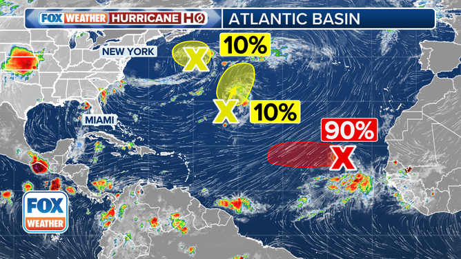
This graphic provides an overview of the tropical Atlantic basin, as well as development odds.
(FOX Weather)
In the latest update from the NHC, forecasters have highlighted a new area to watch for tropical development in the Atlantic.
The NHC said that a non-tropical area of low pressure is located a few hundred miles to the south-southeast of Nova Scotia, Canada.
"While current shower and thunderstorm activity with the system is limited, this system is drifting over the warm waters of the Gulf Stream where some tropical or subtropical development could occur over the next day or two."
BRYAN NORCROSS: TROPICAL DISTURBANCE INVEST 97L LIKELY TO EVENTUALLY TURN NORTH … BUT WHEN?
Forecasters said that by the middle of the week, the system is expected to move northward over cooler waters, ending its chances for further tropical development.
The NHC is giving the area of disturbed weather a low chance of developing over the next week.