Hurricane Julia approaches Central America coast
Julia is not expected to threaten the US Gulf Coast because it will likely be ripped apart by the rugged terrain of Central America as it moves inland from Sunday into early next week.
Julia expected to become hurricane as early as Saturday
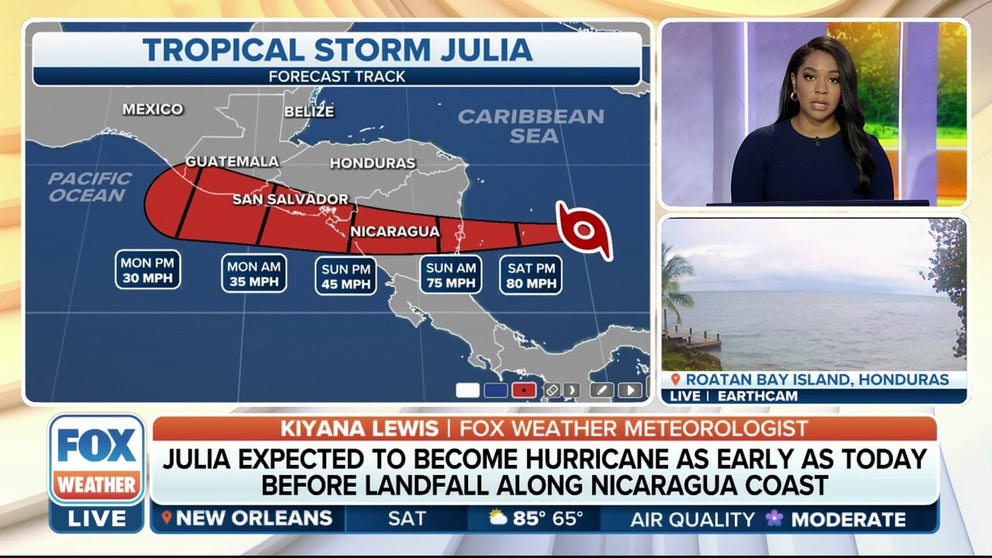
Tropical Storm Julia has formed in the southern Caribbean Sea and is expected to intensify into a hurricane over the weekend as it tracks toward Central America, where it will pose a serious inland flood threat into early next week.
For live coverage of Hurricane Julia visit: Julia strengthens into a hurricane in Caribbean; landfall expected within 24 hours
Hurricane Julia is strengthening as it tracks toward Central America, where it poses a serious inland flood threat into the workweek.
The is not expected to threaten the U.S. Gulf Coast because it will likely be ripped apart by the rugged terrain of Central America as it moves inland.
The Atlantic hurricane season has just under two months remaining, so it's not unusual for the tropics to remain active in October. The month ranks as the third-most active (behind September and August) for tropical activity in the Atlantic Basin, typically producing about two named storms each year, one of which becomes a hurricane.
CENTRAL AMERICA IS PRONE TO HURRICANE DISASTERS
Where is Hurricane Julia?
Hurricane Julia is centered about 170 miles east of Nicaragua.
The cyclone is moving westward at 17 mph and this will put the system onshore sometime during Sunday morning.
A tropical storm is a tropical cyclone with maximum sustained winds between 39 and 73 mph. The National Hurricane Center assigns names to tropical storms using the official name list for that season developed by the World Meteorological Organization.
HOW TO WATCH FOX WEATHER ON TV

(FOX Weather)
What is the forecast for Hurricane Julia?
Julia is forecast to intensify along its journey across the southwestern Caribbean Sea, likely becoming a hurricane by Saturday evening before it reaches the Colombian islands of San Andrés and Isla de Providencia, as well as the coast of Nicaragua on mainland Central America.
According to the FOX Forecast Center, Julia is expected to move across the southwestern Caribbean Sea through Saturday. Julia is then predicted to pass near the Colombian islands of San Andrés and Isla de Providencia on Saturday evening before making landfall along the coast of Nicaragua on mainland Central America on Sunday morning.
After moving inland across Nicaragua, Julia will weaken as it turns west-northwestward and moves across other portions of Central America through Monday.
ATLANTIC HURRICANE SEASON CAN REMAIN ACTIVE IN OCTOBER WITH POTENTIAL U.S. THREATS
(FOX Weather)
"You'll notice that the cone is fairly skinny, and that is showing less uncertainty to the forecast in comparison to what we saw with Hurricane Ian," FOX Weather meteorologist Britta Merwin said. "The dynamics in the atmosphere are pretty much locked in stone, and so we're not going to see a huge variability with the forecast itself."
Where are watches and warnings in effect?
Hurricane Warnings have been issued for the Colombian islands of San Andrés, Isla de Providencia and Santa Catalina and most of the coast of Nicaragua.
A Hurricane Warning means hurricane-force winds (74-plus mph) are expected somewhere in the warning area. A warning is typically issued 36 hours before the anticipated first occurrence of tropical-storm-force winds (39-plus mph), which make outside preparations difficult or dangerous. Preparations to protect life and property should be rushed to completion.
Tropical Storm Warnings have been issued for the entire Pacific coast of Nicaragua, Honduras and El Salvador.
A Tropical Storm Warning means that sustained winds of at least 39 mph are expected in the warning area.

(FOX Weather)
WHAT TO DO WHEN HURRICANE OR TROPICAL STORM WATCHES AND WARNINGS ARE ISSUED FOR YOUR TOWN
What are the impacts of Hurricane Julia?
Hurricane-force winds (74-plus mph) are expected on the Colombian islands of San Andrés, Isla de Providencia and Santa Catalina by Saturday evening, with tropical-storm-force winds (39-plus mph) possibly beginning as soon as Saturday afternoon.
The coast of Nicaragua within the Hurricane Warning area could see hurricane-force winds (74-plus mph) on Sunday morning, with tropical-storm-force winds (39-plus mph) possibly arriving by Saturday night.
Tropical-storm-force winds (39-plus mph) are also possible within the Tropical Storm Watch area in Honduras on Sunday morning.
HERE ARE THE BUZZWORDS YOU’LL BE HEARING DURING HURRICANE SEASON
Additionally, between 6 and 12 inches of rain is likely on the Colombian islands of San Andrés and Isla de Providencia, with 5 to 10 inches expected across portions of mainland Central America. Isolated amounts as high as 15 inches are possible, particularly in Central America.
On Colombia's Guajira Peninsula, between 3 and 6 inches of rain is predicted, with localized totals of up to 10 inches possible.
The FOX Forecast Center said this rainfall could cause life-threatening flash floods and mudslides through this weekend.

(FOX Weather)
Will Hurricane Julia threaten the US?
A blocking high-pressure system is forecast to remain in place north of Julia as it tracks across the Caribbean.
Therefore, the FOX Forecast Center believes Julia will keep heading west across the southwestern Caribbean Sea rather than turn north toward the U.S., sending it on a path through Central America late this weekend and into early next week.
WHERE TROPICAL STORMS AND HURRICANES TYPICALLY OCCUR DURING EACH MONTH OF ATLANTIC HURRICANE SEASON
"We have a ridge of high pressure to the north. That has all the winds rotating clockwise around that ridge of high pressure," Merwin explained. "That's going to be driving Julia right into Central America."
The computer forecast model tracks for Julia are shown on the map below.

(FOX Weather)