Tropical Depression Julia threatens Central America with life-threatening flash floods and mudslides
Julia was the second storm this season to complete a rare crossover from the Atlantic Basin to the Eastern Pacific.
Julia downgraded to tropical depression
Julia has been downgraded to a tropical depression as it has crossed over to the eastern Pacific.
Julia made landfall in Nicaragua early Sunday morning as a Category 1 hurricane. The system has now weakened to a tropical depression after being ripped apart by the mountains of Central America, but there is a continued risk of life-threatening flash floods and mudslides in the region through Tuesday.
On Saturday, Julia strengthened into a hurricane just hours before its landfall near Laguna de Perlas, Nicaragua, with maximum sustained winds of 85 mph.
The Atlantic hurricane season has just under two months remaining, so it's not unusual for the tropics to stay active in October. The month ranks as the third-most active (behind September and August) for tropical activity in the Atlantic Basin, typically producing about two named storms each year, one of which becomes a hurricane.
CENTRAL AMERICA IS PRONE TO HURRICANE DISASTERS
Where is Julia?
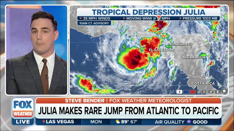
Tropical Depression Julia is centered about 35 miles east-northeast of Puerto San José in Guatemala and has maximum sustained winds of 35 mph.
Julia is moving toward the west-northwest at 15 mph, and this general path is expected to continue through Monday.
HOW TO WATCH FOX WEATHER ON TV

(FOX Weather)
What is the forecast for Julia?
On the forecast track, Tropical Depression Julia will move over southern Guatemala on Monday.
The FOX Forecast Center expects Julia to continue weakening, and the system will likely dissipate on Monday evening.
TROPICAL DEPRESSION VS. TROPICAL STORM VS. HURRICANE: WHAT'S THE DIFFERENCE?
(FOX Weather)
What are the impacts of Julia?
In El Salvador and southern Guatemala, between 5 and 10 inches of rain is expected, with isolated amounts of up to 15 inches of rain possible.
Western Honduras and the Isthmus of Tehuantepec in Mexico can expect 3 to 6 inches of rain, with locally higher amounts of up to 10 inches possible.
An additional 1 to 2 inches of rain is possible in Belize, the remainder of Honduras and northern Guatemala, leading to storm totals as high as 10 inches in some areas.
HERE ARE THE BUZZWORDS YOU'LL BE HEARING DURING HURRICANE SEASON
In Nicaragua, an additional 1 to 2 inches of rain is also possible, resulting in isolated storm totals of up to 15 inches.
The Yucatan Peninsula of Mexico could see another 1 to 3 inches of rain, with localized storm totals approaching 6 inches.
The FOX Forecast Center said this rainfall will pose the risk of life-threatening flash floods and mudslides across Central America on Monday. Flash flooding is also expected across the Isthmus of Tehuantepec in Mexico through Tuesday.

(FOX Weather)
Julia completes rare crossover from Atlantic to Pacific
Julia has performed what few tropical cyclones ever accomplish – maintaining the same name in two ocean basins and giving the Eastern Pacific two "J"-named storms during the 2022 hurricane season.
After making landfall as an Atlantic Basin hurricane on the Nicaraguan coast Sunday, Julia traveled across Central America and later emerged over the Eastern Pacific near the coast of El Salvador while maintaining at least tropical storm strength, and therefore, keeping the name "Julia."
This is the second time this season that a storm has completed the rare Atlantic-to-Pacific crossover. Back in July, Bonnie made landfall as a tropical storm – also along the coast of Nicaragua – and emerged over the Eastern Pacific the following day. That means the Eastern Pacific also had two "B"-named storms during the 2022 hurricane season.
According to National Hurricane Center data, only about a dozen tropical cyclones have successfully crossed from the Atlantic Basin into the Eastern Pacific since the naming convention started in 1950.
Instances of a tropical cyclone maintaining its organization from the Pacific into either the Gulf of Mexico or the Caribbean are even rarer, and it’s only believed to have happened a couple of times.

(FOX Weather)