Dangerous multiday flood threat continues in Texas as risk grows in Minneapolis
The rain is desperately needed in Texas, as parts of the Lone Star State continue to experience extreme drought conditions. However, the excessive precipitation falling on ground that’s extremely dry won’t have time to be absorbed, thus raising concerns of flooding.

Flash flood threat in Plains remains for this week
Texas and other states across the plains are expecting flash flooding this week as slow-moving storms move across the country.
AUSTIN, Texas – The threat of flooding continues to grow for portions of Texas in the southern Plains, while the Minneapolis-Saint Paul area in the Upper Midwest is also at risk of seeing torrential rain this week.
The rain is desperately needed in Texas, as parts of the Lone Star State continue to experience extreme drought conditions. However, the excessive precipitation falling on ground that’s extremely dry won’t have time to be absorbed, thus raising concerns of flooding.

(FOX Weather)
The FOX Forecast Center said confidence continues to grow about a potential heavy rain and severe weather threat that started on Tuesday in Texas and is likely to last through at least the rest of the workweek.
A moist atmosphere, with moisture levels running well above average for early June, is what’s contributing to the threat, with strong instability and plentiful storm energy aiding in the severe thunderstorm development.
As winds remain light in the atmosphere, storms that develop will be slow to move, thus producing high rainfall totals and increasing the flood potential.
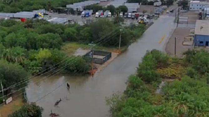
This image shared by the Laredo Police Department in Texas shows flooding near Las Cruces Drive and Mines Road on Wednesday, June 11, 2025.
(Laredo Police Department/Facebook / FOX Weather)
Some flooding was reported in some parts of Texas on Wednesday morning.
The Laredo Police Department said officers were blocking off westbound traffic on Las Cruces Drive because of water on the roadway Wednesday morning.
The FOX Forecast Center said that a stalled cold front will act as a focus point for rounds of heavy rain and storms through the rest of the week, including in areas of the Red River Valley that are already quite saturated from historic rain earlier in the spring.

(FOX Weather)
The flood threat will gradually shift to the east as the week continues, putting the Ark-La-Tex region at risk on Thursday. This includes cities from Houston to Little Rock in Arkansas.
Severe weather was also possible in Texas on Wednesday, with NOAA's Storm Prediction Center (SPC) placing more than 8 million people in a Level 2 threat on its 5-point severe thunderstorm risk scale.
The main threats from storms that had potential to develop on Wednesday will be damaging wind gusts and hail. However, there was also a tornado risk along the Interstate 10 corridor from the San Antonio area to the Houston area.
Flash flood threat grows in Minneapolis this week

(FOX Weather)
There's also a flood concern across portions of the Upper Midwest this week, including the Minneapolis-Saint Paul area.
The FOX Forecast Center said an upper-level disturbance will move out of Canada and allow for an area of low pressure to develop, with a cold front draping itself across Minnesota. While the front will have little in the way of moisture to work with when it arrives, that will change later Wednesday and into Thursday when it begins to stall.
As the front slows and even retreats to the north on Thursday, another area of energy will advance out of the Dakotas and move into Minnesota. The low-level jet stream will then help to funnel in moisture originating from hundreds of miles to the south in the Gulf.
That setup will likely result in days of rain focused on southern Minnesota and into western Wisconsin. The rain will likely break out on Wednesday afternoon, but the heavier precipitation arrives on Thursday.
![This graphic shows the flash flood threat on Thursday, June 12, 2025.]() Image 1 of 2
Image 1 of 2This graphic shows the flash flood threat on Thursday, June 12, 2025. (FOX Weather)
![This graphic shows the flash flood threat on Friday, June 13, 2025.]() Image 2 of 2
Image 2 of 2This graphic shows the flash flood threat on Friday, June 13, 2025. (FOX Weather)
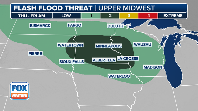
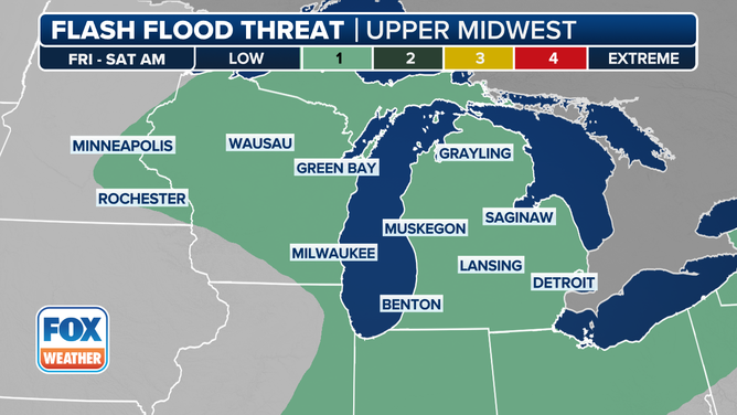
A Level 2 out of 4 threat of flash flooding has been issued for Thursday and into Friday morning, including the Twin Cities of Minneapolis and Saint Paul.
Repeated rounds of rain and thunderstorms over the same areas during that time will likely lead to scattered instances of flash flooding, especially in urban areas with poor drainage. Widespread forecast rain totals of 1-3 inches are expected with locally higher amounts, the FOX Forecast Center said.