Flood Warnings cover part of I-95 corridor as drenching rains soak Northeast
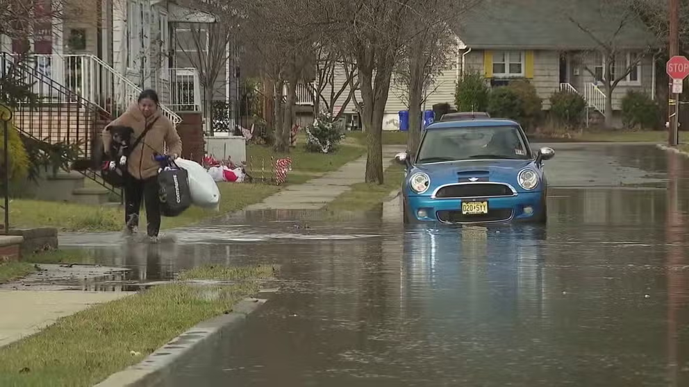
Heavy rains soaked the Northeast Wednesday night, triggering some flooding in New Jersey and Pennsylvania.
Heavy rains leave Flood Warnings across New Jersey and eastern Pennsylvania
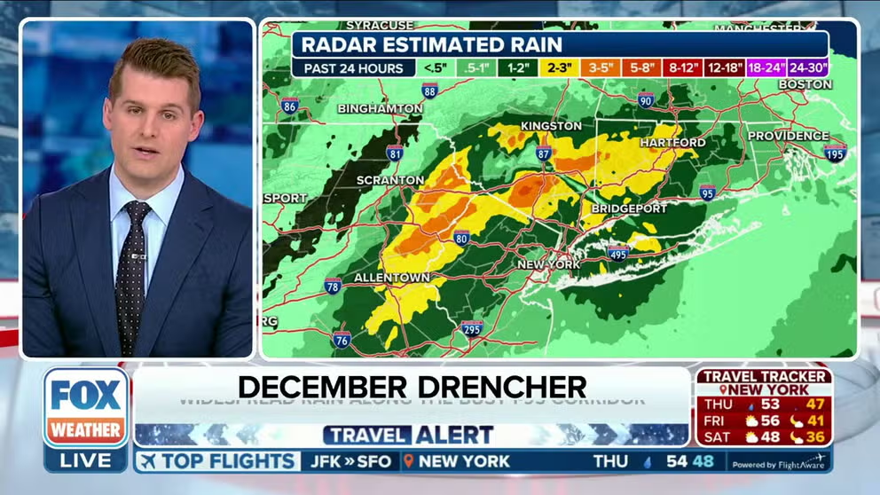
As much as 1-3 inches of rain fell Wednesday night in New Jersey and eastern Pennsylvania, triggering some 60 reports of flooding across the region.
PHILADELPHIA – Heavy rains soaked the Northeast Wednesday night, triggering some flooding in New Jersey and Pennsylvania.
A large plume of moisture continued to work its way up the Eastern Seaboard on Thursday, pushing into New England after leaving widespread rainfall totals measured in multiple inches.

(FOX Weather)
The National Weather Service received over 60 reports of heavy rain and flooding Wednesday into Thursday morning, stretching from northern Maryland across eastern Pennsylvania and New Jersey.
Several streets were closed due to standing water, including Pennsylvania State Highway 32 near Taylorsville and New Jersey Highway 91 in North Brunswick. NWS storm spotters reported some water into homes and basements, with one report of a water rescue in Cheynay, Pennsylvania.
COMPLEX JANUARY FORECAST SHOWS EL NIÑO, POLAR VORTEX, LACK OF SNOW ALL COMING INTO PLAY THIS WINTER
Rain leaves New Jersey residents on high alert
New Jersey residents are on high alert when they see rain in the forecast after last week's flooding. Several houses were flooded, and some cities locked down areas to keep people safe.
All Flood Watches have been dropped as the heaviest rains have moved out of the region. But Flood Warnings remain in effect for several rivers in New Jersey, along with some near the Philadelphia metro area. While Philadelphia reported 1.48 inches at its airport through midnight Thursday morning, some areas in the region have received as much as 2-3 inches of rain so far.

(FOX Weather)
The heaviest rain will push into New England later Thursday and will be over by Thursday night, but the slow-moving system will keep a chance of showers in the forecast through late Friday and even into Saturday morning.

(FOX Weather)
TRAVEL WEATHER LIVE TRACKER: CURRENT RADAR, AIRPORT STATUS, FLIGHT DELAYS AND MORE
Roads will be wet, too, but not super slippery. This is a warm system, and most of the precipitation will fall as rain, though there is a possibility of some flurries late Friday.
"Maybe you're traveling. Maybe you're heading home," Morgan said. "AAA is expecting that Thursday is going to be one of the busiest days as folks are going to be hitting the road, heading back home Thursday. Wednesday into Thursday is going to be also the wettest day of this week. So, we'll watch that along that I-95 corridor."
WHY DROP A BALL ON NEW YEAR'S EVE WHEN POTATOES, TACOS AND CHEESE ARE OPTIONS?
New Year's Eve not necessarily a washout
New Year's Eve will not necessarily be a washout, though, as a weak ridge forms over the Northeast and sets up dry conditions.
"Don't be deceived by this – these next three days – because in New York City, things are going to be improving," Morgan said. "We're dealing with the cloudy, sort of gloomy conditions followed by the rain, but, overall, we're going to see things dry out for the New Year."
THE NATIONWIDE NEW YEAR'S EVE FORECAST
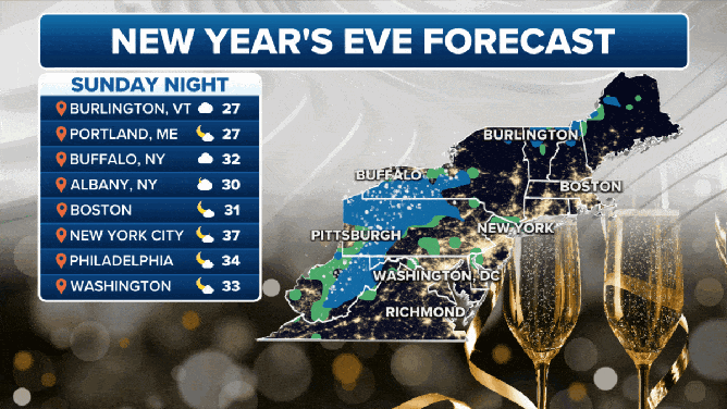
The coast is clear but rain and snow are in the New Year's Eve forecast from Pittsburg to Buffalo, New York.
(FOX Weather)
Inland areas from West Virginia through Pittsburgh and into Buffalo, New York, will not be so lucky, though. While the coast is clear, a mix of rain and snow is forecast from western New York into the Appalachians.