Complex January forecast shows El Nino, polar vortex, lack of snow all coming into play this winter
NOAA forecasters believe El Niño will remain the major climate driver through the winter. Complicating forecasts are the lack of snow cover across the U.S. and Canada, a warm Pacific Ocean and a pending disruption of the polar vortex.

Polar vortex forecast a 'nail-biter,' expert says
Judah Cohen, Director of Seasonal Forecasting at Verisk's Atmospheric and Environmental Research (AER), discusses the latest outlook for the polar vortex and what it could mean for U.S. weather in the beginning of 2024.
The latest NOAA climate outlook shows the weather pattern that has dominated the winter season in the U.S. thus far will likely stick around for the first quarter of 2024, with just a few modifications.
In the outlook released Thursday, the Climate Prediction Center said it believes that January’s temperatures will, on the whole, average either at or above normal during what is typically the harshest month for winter weather.
"El Niño remains the major climate driver and is expected to be the primary influence on the mid-latitude circulation pattern and associated January temperature and precipitation," NOAA forecasters stated.
![January 2024 temperature outlook]() Image 1 of 2
Image 1 of 2January 2024 temperature outlook ( )
![January 2024 precipitation outlook]() Image 2 of 2
Image 2 of 2January 2024 precipitation outlook ( )


EL NIÑO APPEARS TO BE ON VERGE OF RAPID COLLAPSE
A warm Pacific Ocean, combined with a lack of snow cover in the northern U.S. and southern Canada, is helping modify any cold airmass that tries to invade the country.
In fact, the country is on track to have one of its least snowy Christmases on record, with a little more than 10% of the Lower 48 expecting snow on the ground on Dec. 25.
A lack of snow in many parts of the Midwest will likely continue through much of winter, with much of the southern tier of the country remaining stormy.

(FOX Weather)
With increased cloud cover and rain comes cooler temperatures, but the mercury is far from record-breaking territory.
The pattern is typical of an El Niño event, which is expected to weaken in 2024, but no two El Niños are the same and are not the only feature influencing the weather.
A factor that NOAA forecasters said could lead to changes in its January and 3-month outlook is the influence of the polar vortex.
Polar vortex disruption impacts expected to be limited in US
A question that forecasters face every year is when will the polar vortex break down, which usually sends cold air spewing into more southern latitudes.
When this arctic air makes it into Canada and the U.S., it can lead to some of the harshest winter conditions and drop temperatures below zero. If the cold air combines with moisture, communities can see significant snowfall.
Forecasters believe a disruption to the current flow will happen in the new year, but early indications are that the air mass won’t send the country into tundra territory.
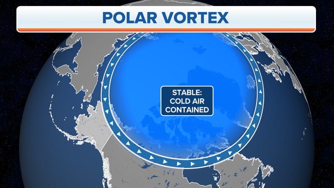
A stable Arctic Polar Vortex.
(FOX Weather)
"There isn’t a one-to-one correlation between what’s happening with the polar vortex and our weather, and also, there’s a delay," Judah Cohen, Ph.D. and an atmospheric and environmental scientist who studies the polar vortex, told FOX Weather. "So, you’ve been talking about a sudden stratospheric warming. It takes about two weeks for the effects of the sudden stratospheric warming to impact our weather. So that’s why it’s very useful for forecasting – because of the delay."
Cohen said he believes that cold air will eventually make it to the U.S., but the event will "fall short of its full potential." In other words, cold air is on the way in January, but the exact extent is still unknown.
The first month of the year is usually the coldest for much of the United States, with the halfway point of meteorological winter being about Jan. 15.
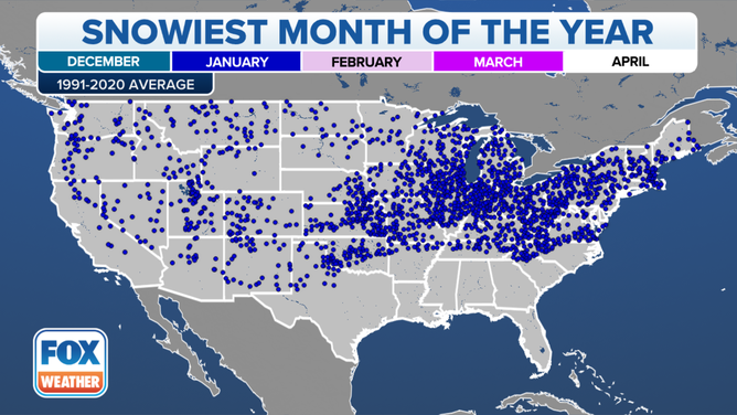
January is the snowiest month for the locations plotted on this map, according to the most recent 30-year climatological averages (1991-2020).
(FOX Weather)
Forecasters said that the NOAA outlook does not mean pool days will be in store for places such as New York, Chicago or even Minneapolis – it’ll still be chilly but not at the normally frigid levels. For instance, an average mid-January day in Minneapolis starts out at 8 degrees, and the high temperature only reaches the mid-twenties. In recent days, highs have reached the 30s and 40s, and lows have generally been in the 20s, which are all above average.
So, even though the temperature anomaly map may continue to resemble a blowtorch, the weather will still be pretty cold for many.