Damage reported as start of severe weather outbreak rips across heartland Monday
According to local storm reports tallied by the National Weather Service, there were at least three reports of tornadoes in northeastern Oklahoma, more than 40 reports of damaging winds or wind damage from Texas to Kentucky and over 60 reports of large hail from Texas to Ohio.
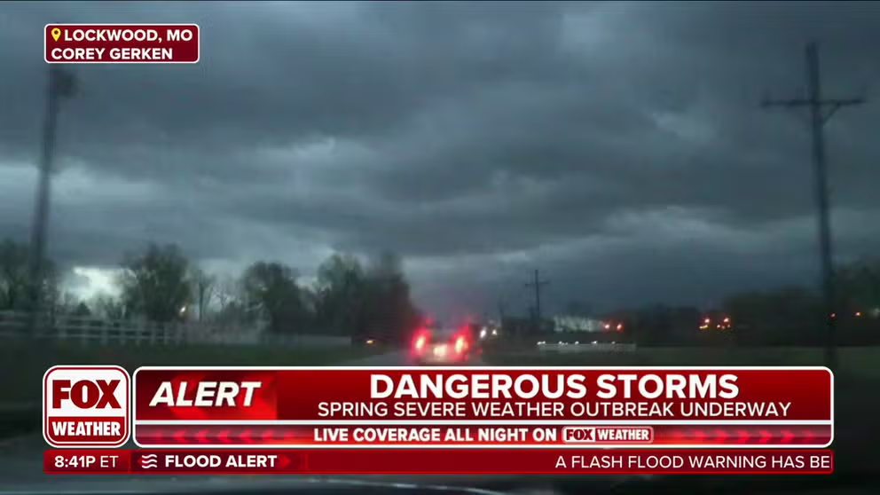
Storm tracker follows storms in nation's heartland
FOX Weather Meteorologist Steve Bender talks to storm tracker Corey Gerken as he follows storms in Missouri.
April typically kicks off the most active three months for tornadoes in the U.S., and this year is no exception as a widespread multiday severe weather outbreak is expected to impact tens of millions of Americans in the eastern half of the country through Tuesday.
On Monday, NOAA's Storm Prediction Center issued the year's first Level 4 out of 5 risk for severe weather, centered over central and eastern Oklahoma and far North Texas, where storms were forecast to produce destructive hail upwards of 2-3 inches in diameter. That area was removed by Monday night, but a Level 3 out of 5 risk zone remained in a swath from Texas to Ohio.

(FOX Weather)
Severe storms began to erupt in the central U.S. Monday afternoon and continued throughout the night before spreading east on Tuesday morning.
The storms have produced both large hail and damaging winds that caused damage Monday and Monday night from Texas to the lower Ohio Valley.
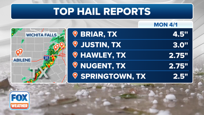
The top hail reports on Monday, April 1, 2024.
(FOX Weather)
According to local storm reports tallied by the National Weather Service, there were more than 40 reports of damaging winds or wind damage from Texas to Kentucky and over 60 reports of large hail from Texas to Ohio.
The largest hail report was grapefruit-sized hail (4.5 inches) near Briar, Texas, while the highest wind report was an 88-mph gust near Albany, Texas.
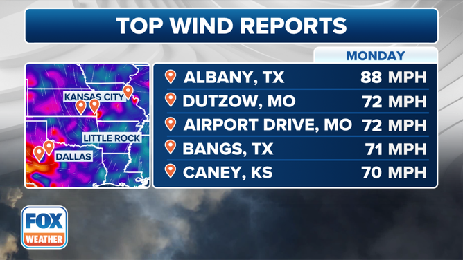
The top wind reports on Monday, April 1, 2024.
(FOX Weather)
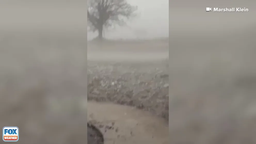
According to the NWS, hail the size of hen eggs was reported near Logan, Oklahoma. Wind-blown hail broke windows in Caney, Kansas. In Missouri, hail the size of golf balls was reported falling hard in Chesterfield for about 5 minutes. Baseball-sized hail was reported near the town of Nugent in Texas, while baseball-sized hail damaged vehicles and broke the windows of a home in Hawley, Texas. Video showed hail covering the ground in Boyd, Texas, on Monday evening.
Hail covers yard in Texas
Video shows hail covering the ground in Boyd, Texas, on April 1, 2024.
Wind damage has also been reported. According to the NWS, law enforcement near Sweetwater, Texas, reported multiple power poles had been knocked down. A roof was ripped off a home in Shackelford, Texas, near where the day's highest wind gust of 88 mph was recorded. Trees and power lines were blown down in Independence, Kentucky. In Missouri, trees were knocked down in the town of Westphalia.
On Monday evening, Carthage, Missouri, reported damage around the historic downtown square from a possible tornado. The town was placed under a Tornado Warning about 9:30 p.m. CDT, warning of 70-mph winds and quarter-sized hail. Prior to hitting Carthage, the storm produced a 73-mph gust in Joplin, Missouri.

A Tornado Warning was issued for Carthage, Missouri, at 9:33 p.m. CDT Monday. It was also warned for 70-mph winds and quarter-sized hail.
(Carthage Water & Electric Plant (CWEP))
Additionally, there were at least three reports of tornadoes in northeastern Oklahoma on Monday evening.
According to the NWS, a tornado near Lenapah, Oklahoma, rolled over a tractor-trailer, trapping one person inside. Another tornado was reported near the town of Hominy, Oklahoma. Storm spotters near Bartlesville, Oklahoma, also reported a tornado crossing Highway 75.

Watch: Funnel cloud forms as Tornado Warnings hit Oklahoma
A funnel cloud was spotted in central Oklahoma on Monday as the National Weather Service put the region under a Tornado Watch. Footage filmed by Kristy Turner shows the funnel moving across the town of Kingfisher, northwest of Oklahoma City.
Kristy Turner captured the footage above showing a funnel cloud moving across Kingfisher, Oklahoma, which is located northwest of Oklahoma City.
"My husband and I were watching the news as we were expecting bad weather. We went to the door and stepped outside and this is exactly what we saw," she said.
Both Tornado and Severe Thunderstorm watches were issued Monday and Monday night for several states.

(FOX Weather)
Strong, long-track tornadoes expected in Ohio Valley on Tuesday
A potentially substantial severe weather outbreak – including the threat of a few strong, long-track tornadoes – is expected Tuesday afternoon and evening, with the highest tornado threat centered over the Ohio Valley.
NOAA's Storm Prediction Center has issued a Level 4 out of 5 risk for severe weather in parts of Ohio, northern Kentucky and southeastern Indiana. This includes the cities of Columbus, Cincinnati and Dayton in Ohio, as well as Louisville and Lexington in Kentucky.
The threat of severe weather also extends as far south as the Gulf Coast and as far east as western portions of Virginia and the Carolinas, including major cities such as Nashville in Tennessee, Birmingham in Alabama, Atlanta in Georgia and Tallahassee in Florida.
Click here for the latest updates on Tuesday's ongoing severe weather outbreak.

(FOX Weather)
Severe weather threat shifts to East Coast on Wednesday
Severe thunderstorms packing threats of damaging winds and hail are possible Wednesday across parts of the eastern Carolinas and mid-Atlantic, with a second severe weather threat area expected over the Florida Peninsula.
Wednesday's threat zone includes the cities of Richmond and Virginia Beach in Virginia, Hatteras in North Carolina and Jacksonville and Tampa in Florida.
WHICH U.S. COUNTIES ARE MOST AT RISK OF TORNADO DAMAGE?

(FOX Weather)
Be sure to check back with FOX Weather for updates on this ongoing severe weather outbreak. You can download the free FOX Weather app and enable notifications to receive real-time alerts about any severe weather headed your way.