3 killed amid Oklahoma’s deadliest tornado in 10 years as multiday severe weather threat unfolds
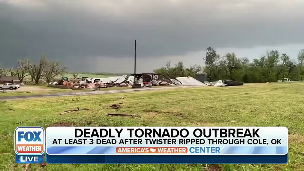
At least three people were confirmed dead in Cole, Oklahoma, after a tornado rating at least an EF-3 struck the town Wednesday night, according to officials. It's the deadliest tornado to strike Oklahoma in the last 10 years.
NWS: EF-3 tornado damage found in Cole, Oklahoma
A National Weather Service Norman Oklahoma survey crew near Cole found a home with EF-3 damage.
COLE, Okla. – Severe thunderstorms turned deadly as they erupted across the Plains Wednesday evening, beginning a multiday threat of large hail, wind damage and tornadoes each day through Saturday.
Thunderstorms produced more than a dozen tornado reports and nearly 150 reports of large hail across six states in the central U.S.
The most significant damage so far was reported from a tornado-producing supercell that swept over 130 miles across the southern edge of the Oklahoma City metro area.
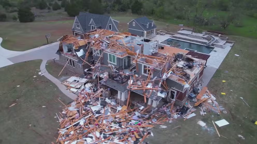
Drone video shows homes flattened, cars tossed from deadly tornado in Cole, Oklahoma
Drone video shows homes flattened and cars tossed from a deadly tornado in Cole, Oklahoma.
At least three people were confirmed dead in Cole, Oklahoma, after a tornado struck the town Wednesday night, according to the McClain County Sheriff's and Emergency Management offices, making the storms the deadliest in the state in the last 10 years.
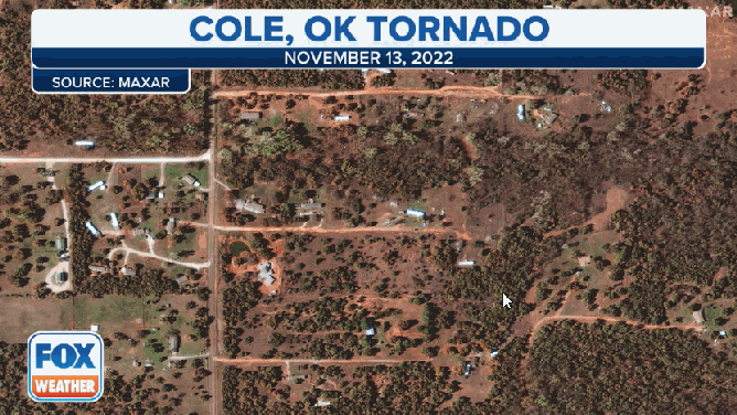
Satellite imagery before and after a tornado moved through Cole, Oklahoma on April 19, 2023.
(FOX Weather / FOX Weather)
So far, storm survey teams with the National Weather Service have found damage near Cole consistent with EF-3 tornado, meaning tornadic wind speeds of at least 136 mph, along with evidence of an EF-0 tornado just south of Tinker.
HOW ARE TORNADOES RATED? THE ENHANCED FUJITA SCALE EXPLAINED
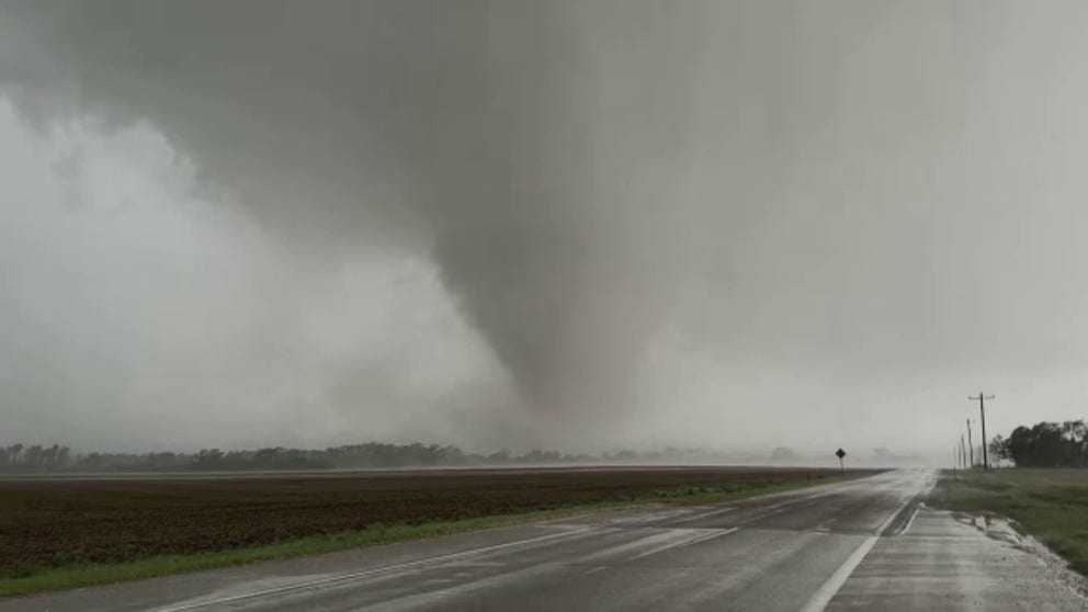
Large tornadoes moved through Cole and Shawnee, Oklahoma during deadly outbreak
Large tornadoes moved through Cole and Shawnee, Oklahoma on Wednesday during a deadly tornado outbreak.
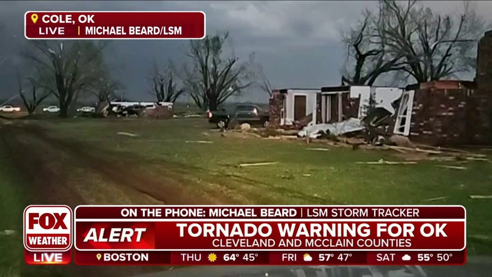
Storm Tracker Michael Beard spotted damage to several buildings and trees in Cole during the severe weather. At least one agricultural facility appeared to be destroyed by the tornado.
"Most of the houses around here only suffered minor damage, but these two homes right here are completely destroyed," Beard told FOX Weather while surveying the damage. "Neighbors are helping neighbors whose houses that weren't hit. As soon as the all clear was given and the storm stopped raining and the winds ended, the hail stopped – the entire city has come out to try and help find anybody. If they need help, pull them out, just generally helping each other."
Homes damaged by a tornado in Cole, Oklahoma
Storm tracker Michael Beard spotted damage after a tornado rolled through central Oklahoma on Wednesday.
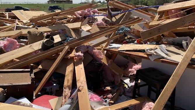
McClain County Sheriff Scott Gibbons said two people were killed in storms outside the town of Cole while a third person injured in the storms later died after being rushed to a local hospital.
"We don’t have a hard number yet but we’re going to have quite a few homes, a couple of businesses and a large number of vehicles that are going to be a complete loss," Gibbons told FOX Weather.
Though from the rubble came a story of survival of a family that knew what to do when the tornado came for their neighborhood.
"(A storm) survey crew in McClain County (near Cole) just uploaded this picture back to the office," tweeted NWS meteorologists in Norman, Oklahoma:
A home sits damaged after a tornado swept through Cole, Oklahoma on April 19, 2023.
(National Weather Service, Norman, OK / NOAA)
"Four people were in this house when the tornado hit. All survived by sheltering under a mattress in their mud room."
TORNADO SAFETY: HOW TO IDENTIFY THE SAFEST PLACES INSIDE YOUR HOME
Tornado damage reported in Shawnee, Oklahoma
As the storms moved east, another apparent tornado was reported in the town of Shawnee, causing significant damage.
"Fellow Shawnee residents, our Community was hit hard by this evening's storms," Shawnee Police said in a Facebook post. "Please know that search and rescue efforts are underway… If you can, check on your neighbors, but be mindful of potential gas leaks and possibly downed power lines."
Video from around Shawnee showed several buildings damaged around town, including at Oklahoma Baptist University.
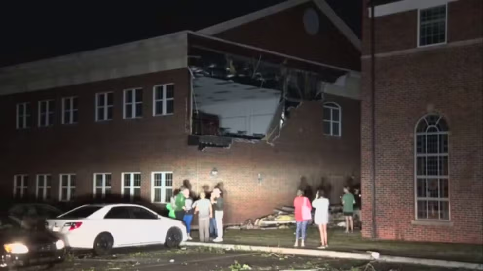
Tornado causes significant damage to Oklahoma Baptist University in Shawnee
A tornado caused significant damage to Oklahoma Baptist University and throughout Shawnee, OK on Wednesday.
"No injuries have been reported but damage to campus is significant," Oklahoma Baptist University officials tweeted Wednesday night.
A wind gauge near the northern edge of town reported a gust of 84 mph as it was likely clipped by the storm.
"This was a long-lived, long-tracked wedge tornado – a massive tornado that we were tracking on the ground for almost about two hours," FOX Weather meteorologist Britta Merwin said. "The tops of these clouds of this tornado were 45,000 feet."
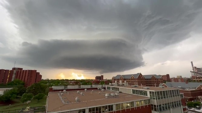
A supercell thunderstorm moves into Norman, Oklahoma, on April 19, 2023.
(@tarver_garrett /WEATHER TRAKER / TMX / FOX Weather)
PowerOutage.US reported nearly 20,000 outages in the Sooner State on Wednesday night.
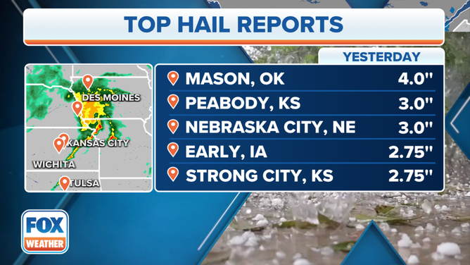
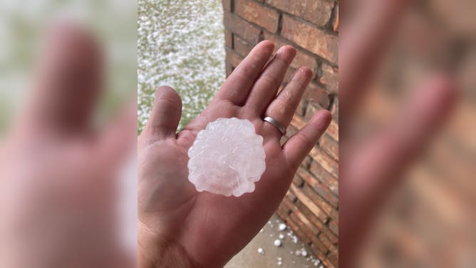
Hail stones reached 4 inches in diameter in Oklahoma
The towering supercells led to reports of massive hailstones across parts of six states Wednesday.
Hail was reported in several communities in Iowa, Illinois and Wisconsin from an earlier round of storms Wednesday. Hail stones became even larger as the thunderstorms moved int Oklahoma, Kansas, and Nebraska.
(FOX Weather)
A spotter in Mason, Oklahoma reported a hail stone of 4 inches in diameter -- about the size of a softball. Hail measuring 3 inches across fell in Peabody, Kansas and Nebraska City, Nebraska.
Radar also indicated very large hail impacting rural communities in southwestern Iowa. Meteorologist and storm chaser Brett Adair with Live Storms Media lost his windshield while tracking storms in Hastings, Iowa.
"We were trying to move out ahead and beat the hail core, but we were unable to do that," Adair told FOX Weather. "So we unforuntatly took some baseball(-sized hail) and lost portions of the windshield there."
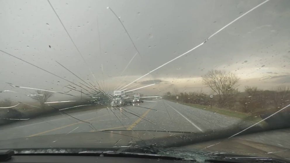
WATCH: Large hail cracks storm chaser's windshield in Iowa during severe storms
Large hail cracked storm chaser Brett Adair's windshield in Hastings, Iowa during severe storms on Wednesday.
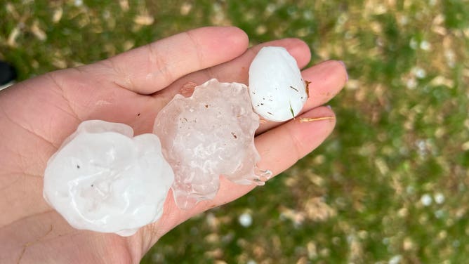
Meteorologists estimated that the hailstones could be the size of tennis balls or grapefruits.
Baseball to softball-sized hail stones can fall from the sky at speeds of 80-100 mph or more.
"That is not only the type of hail that will damage your car, but also damage your home," said FOX Weather Meteorologist Jason Frazer.
HOW LARGE IS ‘GOLF BALL-SIZED HAIL’ AND OTHER HAIL MEASUREMENTS?
Storm trackers captured video of hail crashing into Blanchard, Oklahoma on Wednesday.
![Hail in Chickasha]() Image 1 of 5
Image 1 of 5Baseball-sized hail in Chickasha, Oklahoma. (@Daradondo/Twitter)
![Tennis ball sized in Oklahoma]() Image 2 of 5
Image 2 of 5Tennis ball-sized hail in Chickasha, OK (@rlweather98/Twitter)
![Oklahoma hail]() Image 3 of 5
Image 3 of 5Large hail fell over Edmond, Oklahoma. (@KatieReneeJ/Twitter)
![]() Image 4 of 5
Image 4 of 5Marble and golf ball size hail south of the Oklahoma City metro. (@heathercritter/Twitter)
![]() Image 5 of 5
Image 5 of 5Marble and golf ball size hail south of the Oklahoma City metro. (@heathercritter/Twitter)


During the evening commute, drivers along several interstates found shelter under overpasses, which is not an advised safety precaution during a Tornado Warning due to the potential for flying debris.
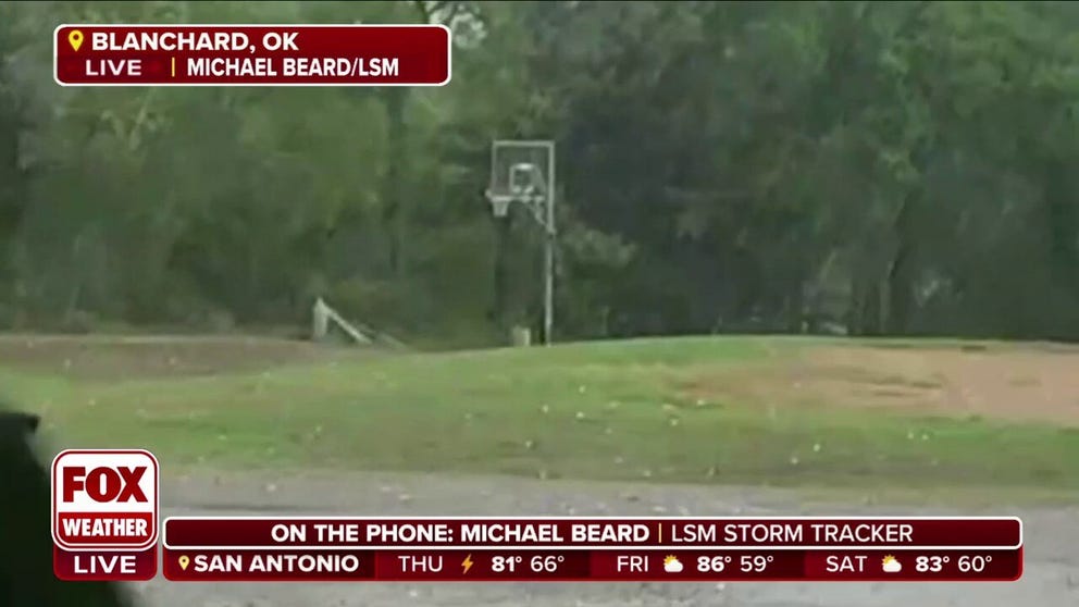
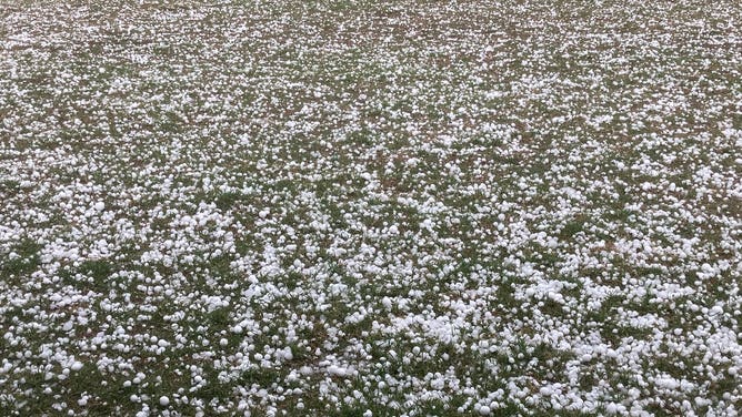
Baseball-sized hail slams Oklahoma
Storm trackers captured video of hail crashing into Blanchard, Oklahoma on Wednesday.
Overall, the National Weather Service received over 130 reports of large hail of at least 1 inch in diameter on Wednesday.
Severe storms spread east on Thursday
The severe weather threat extends into Thursday as thunderstorms, including supercells, are predicted to develop along and ahead of a cold front from parts of Texas into the lower and mid-Mississippi Valley.
Additional tornadoes, large hail, damaging wind gusts and dangerous lightning will be possible as the cold front charges across the region.
MULTIDAY SEVERE WEATHER THREAT SPREADS EAST AS COLD FRONT CHARGES ACROSS TEXAS, MISSISSIPPI VALLEY
The threat then moves toward areas along the Gulf Coast on Friday and shifts to the Southeast coast by Saturday.

(FOX Weather)