Severe weather threat lingers in mid-Atlantic as storm system begins final leg of trip across US
A storm system that has stirred up severe weather across the country this week is on its final leg, with thunderstorms hugging the East Coast of the U.S.
Severe storms threaten Virginia, Florida on Wednesday
The severe weather threat shifts to the East Coast on Wednesday, placing portions of the mid-Atlantic states and Florida at risk of damaging winds, large hail and a couple of tornadoes.
WASHINGTON – A severe weather outbreak that caused damage from Texas to the Ohio Valley and the Southeast and led to the death of one person in Kentucky continued for the third straight day Wednesday. This time, the worst weather happened along the East Coast, particularly in parts of Virginia and Florida.
Due to atmospheric conditions not being as conducive for severe weather, chances for damaging winds, large hail and tornadoes are lower than Monday and Tuesday.
"So, we go from a (Level) 4 out of 5 risk now to a 2 out of 5," FOX Weather Meteorologist Steve Bender said. "It doesn't mean you let off the gas pedal. You still think about what those threats can be."
NOAA's Storm Prediction Center highlighted two separate areas as having the greatest risk of severe weather Wednesday – one stretching from Delaware to northern North Carolina and another extending across North and Central Florida.

(FOX Weather)
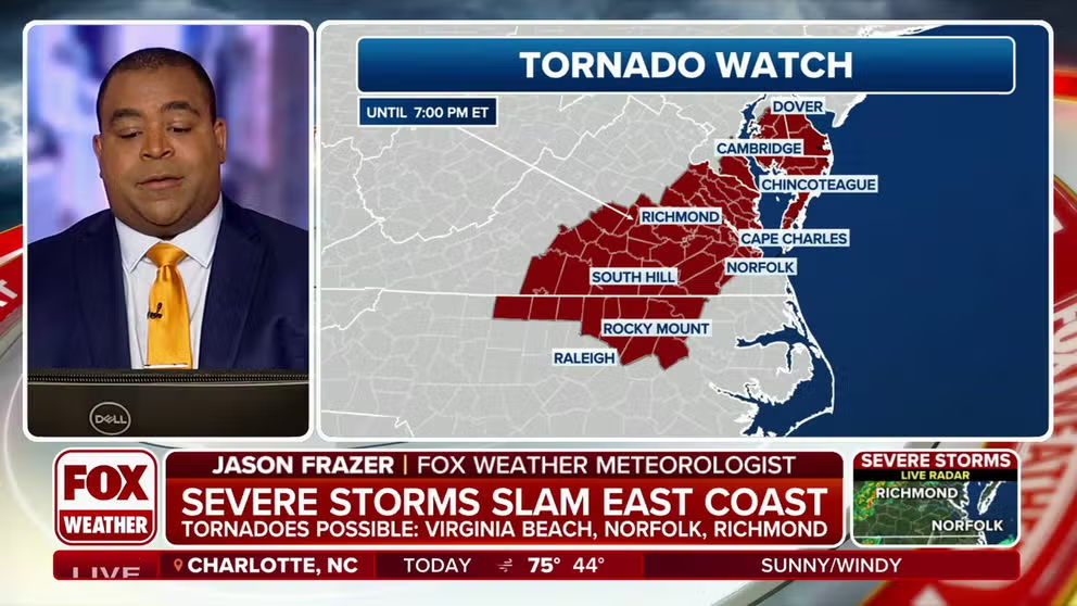
A Tornado Watch has been issued in the mid-Atlantic region but does not include Washington or Baltimore.

(FOX Weather)
Overall, nearly 30 million people in these regions face the risk of damaging wind gusts, large hail and a tornado or two.
OHIO ELEMENTARY SCHOOL’S ROOF RIPPED OFF BY SEVERE STORM WHILE STUDENTS WERE ON SPRING BREAK
What are the storms doing right now?
A cold front continues to march past the East Coast, with plenty of showers and thunderstorms ahead of it.
The storm system is fast-moving, with some thunderstorms moving east at more than 50 mph.

(FOX Weather)
Some of the storms continue to turn severe, prompting warnings for several counties.
SEVERE WEATHER OUTBREAK PRODUCES TORNADOES, DAMAGE FROM OHIO VALLEY TO SOUTHEAST
The majority of the storms are expected to move off the East Coast by sunset, but the winter weather on the northern end of the storm system will linger through at least Thursday.
April is usually 2nd-busiest month for severe weather
The fourth month of the year typically sees an increase in severe weather outbreaks as seasonal air masses clash over the eastern half of the country. In fact, April is usually the second busiest for tornadoes, only outdone by May.
A global climate pattern known as El Niño is known to clamp down on severe weather outbreaks in the Lower 48.
The year seems to be following the norms set during previous El Niño events.
Data from NOAA's Storm Prediction Center shows tornado activity for the year is below average, while hail and damaging wind reports are closer to average.

(FOX Weather)