Millions across Plains in path of dangerous hail, tornadoes as rounds of severe storms extend through weekend
Several systems will track across the Plains and Mid-South through at least Monday, placing more than 40 million at risk, with peak impacts expected over weekend.

Severe weather 'marathon' targets Plains, Mid-South, with threats of large hail, possible strong tornadoes this weekend
A severe weather marathon targets the Plains and Mid-South, with millions of Americans at risk each day from Friday through at least Monday. Large hail, damaging winds and strong tornadoes are all possible. Stay with FOX Weather LIVE all weekend for the latest updates to keep you safe.
We are tracking multiple days of severe weather, which is not expected to ease up until next week. Several systems will move across the Plains and Mid-South through at least Monday, putting more than 40 million Americans at risk, with the greatest impacts expected this weekend.
NOAA's Storm Prediction Center said storms capable of producing tornadoes, hail and damaging wind gusts are most likely to form from the Southern and Central Plains into the upper Midwest before the threat shifts south and east into the Mississippi Valley on Friday as a cold front pushes east.
With ample instability and wind shear, severe storms will remain possible through the afternoon.
(FOX Weather)
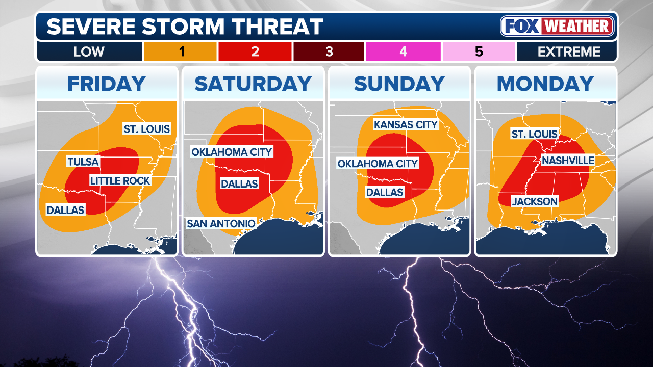
These storms are expected to impact portions of northeast Oklahoma, southern Missouri and northern Arkansas. There is a Level 2 out of 5 severe storm risk in place.
RISING WATERS: DAYS OF HEAVY RAIN CAUSE RIVERS IN MICHIGAN AND WISCONSIN TO EXCEED LIMITS
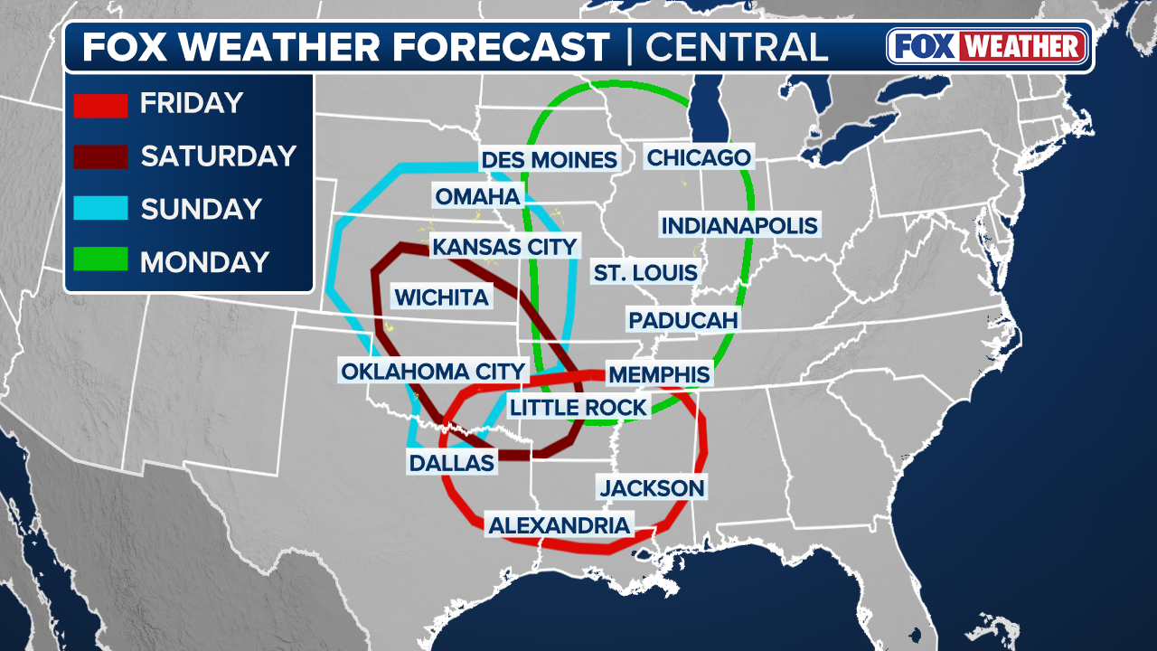
Cities included in Friday's threat area include Tulsa, Springfield, Shreveport and Little Rock, according to the FOX Forecast Center.
At this time, large hail and damaging wind gusts appear to be the primary threats that come with any of the storms that develop.
This is due to likely moderate amounts of wind shear, as storms will likely form in clusters instead of the isolated, intense supercells that often produce the most impactful weather.

(FOX Weather)
Severe weather is expected to continue and increase on Saturday, with storms developing in the late afternoon along a lifting warm front across the Southern Plains.
A highly unstable environment will initially support supercell development, with these storms eventually growing into a line capable of producing all severe hazards, including tornadoes.
This has prompted a Level 3 of 5 severe storm risk across portions of southern Kansas and northern Oklahoma, which includes Wichita and Tulsa.
WHAT IS A DRYLINE AND WHY IS ITS LOCATION IMPORTANT IN SEVERE WEATHER FORECASTING?
Come Sunday, another system is expected to develop across the Plains, with a sharp dryline extending south into Oklahoma.
The FOX Forecast Center is highlighting this as a 'boom or bust' scenario. Forecasts indicate a strong cap may be in place, potentially keeping severe storms from developing until much later in the day.
(FOX Weather)
On the flip side, strong southerly winds ahead of the system will transport ample moisture northward, combining with strong instability and wind shear, which could produce strong storms with all hazards possible if the cap is not in place.
A Level 3 out of 5 severe storm risk is already in place from central Oklahoma into southern Kansas, including Oklahoma City and Wichita.
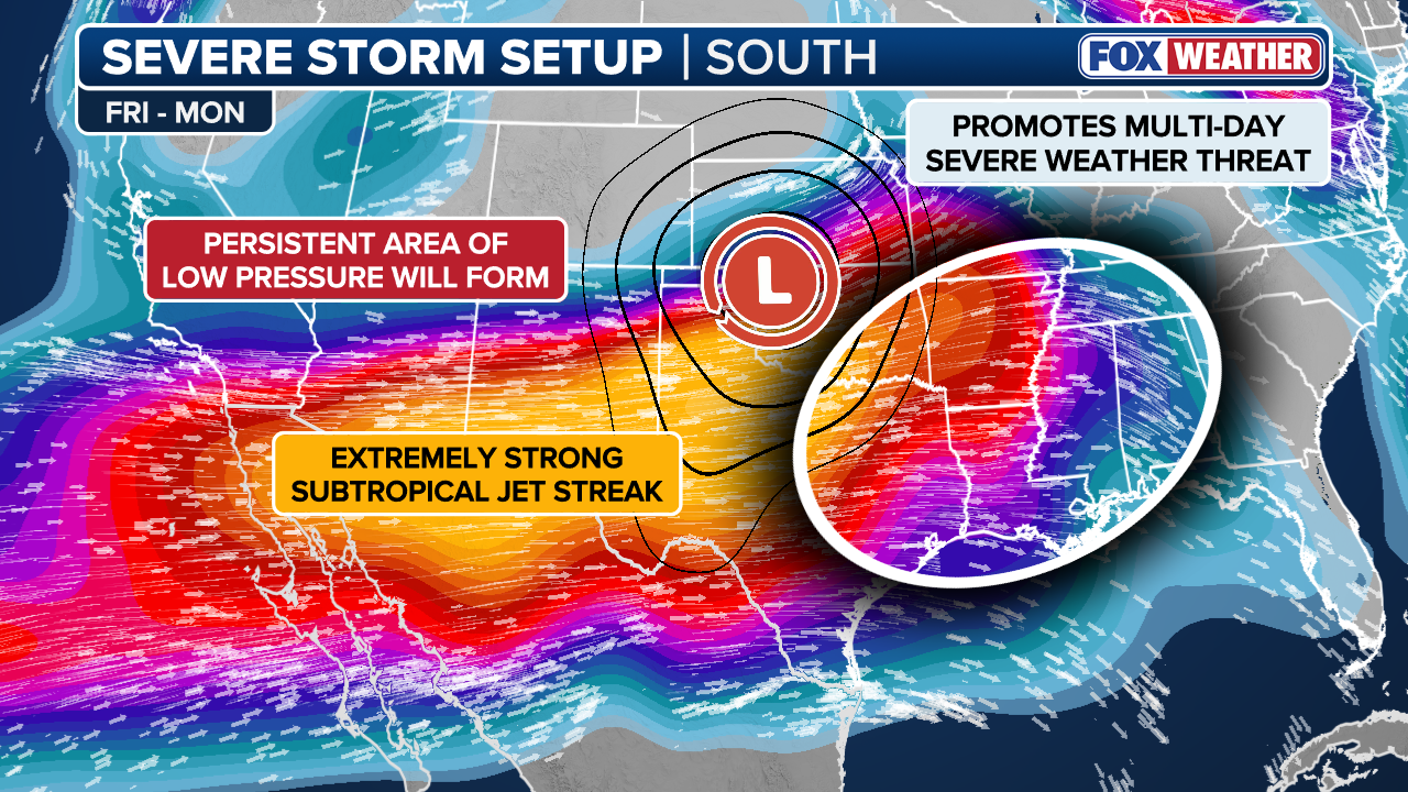
By Monday, the storm system will be racing northeast, dragging the surface low with it from the Central Plains all the way up into the Upper Mississippi Valley.
As that happens, a warm front will surge rapidly northward, pushed along by a powerful low-level jet.
This will lead to a lot of rain north of the front, with widespread precipitation likely to put a limit on how far north Monday afternoon's severe weather can reach.
With that, the FOX Forecast Center said the setup looks quite threatening to the south. New storms are expected to fire along an advancing cold front and dryline, moving into an atmosphere that will be primed and ready through the afternoon.
(FOX Weather)
Strong daytime heating of a very moist air mass will likely boost the instability and support vigorous thunderstorm development, leaving all threats on the table on Monday.
A Level 3 risk has been issued across the Mid-Mississippi Valley including St. Louis and Paducah, with a much larger Level 2 threat from southern Wisconsin into northern Louisiana.
However, the FOX Forecast Center said the severe storm threat on Monday will depend entirely on how Sunday unfolds.
"If severe storms are not widespread across the Plains on Sunday, greater moisture and instability may stream into the Lower Mississippi Valley, potentially supporting a higher-end severe weather event," the team noted.
That said, the threat could continue into Tuesday across the Southern Plains and Southeast, but uncertainty still remains on where the storms will set up.
WHAT IS A SUPERCELL THUNDERSTORM?
With multiple days of rain over the same areas, flash flooding will be possible. A widespread 2 to 3 inches of rain is expected through Tuesday from Missouri to Georgia, with localized totals of 3 to 5 inches or more possible across Mississippi, Alabama and Tennessee.