Pre-Thanksgiving storm will bring rain, some snow to Northeast, Midwest
Major travel disruptions appear unlikely due to this storm
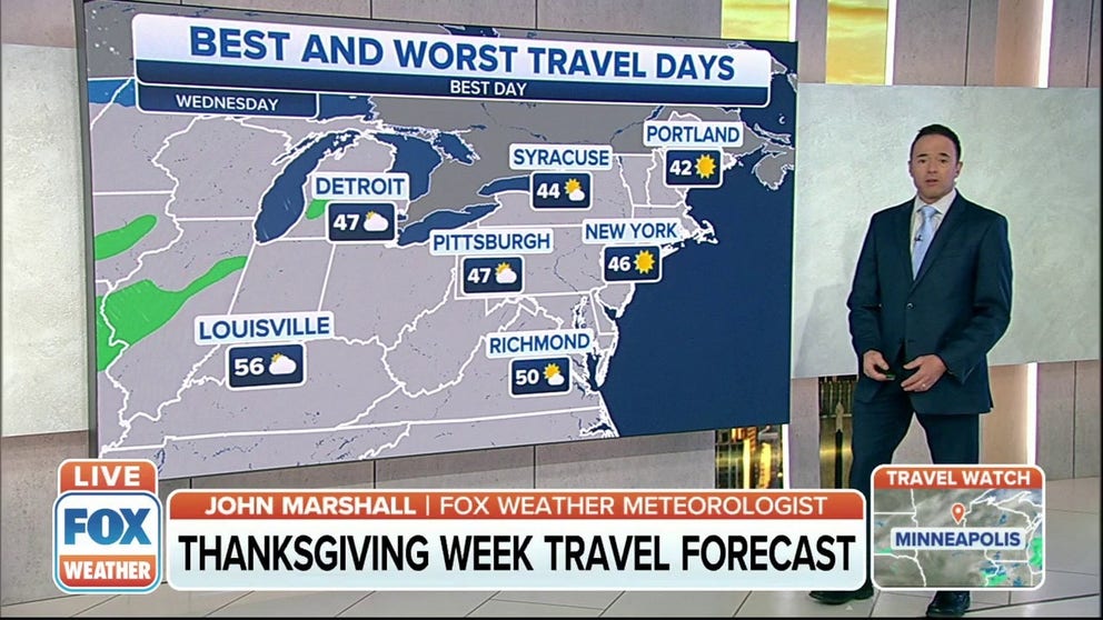
Here's a look at your Thanksgiving week travel forecast
FOX Weather gives you the best and worst travel days for the upcoming Thanksgiving holiday weekend.
Early Thanksgiving travelers might have to contend with a storm this weekend and early next week, with rain and some snow potentially causing some disruptions on the roads and in the air across the Northeast and Midwest.
According to AAA, an estimated 53.4 million people will hit the road or catch a flight this Thanksgiving, which is up 13% from 2020 and brings the volume to within 5% of pre-pandemic levels in 2019.
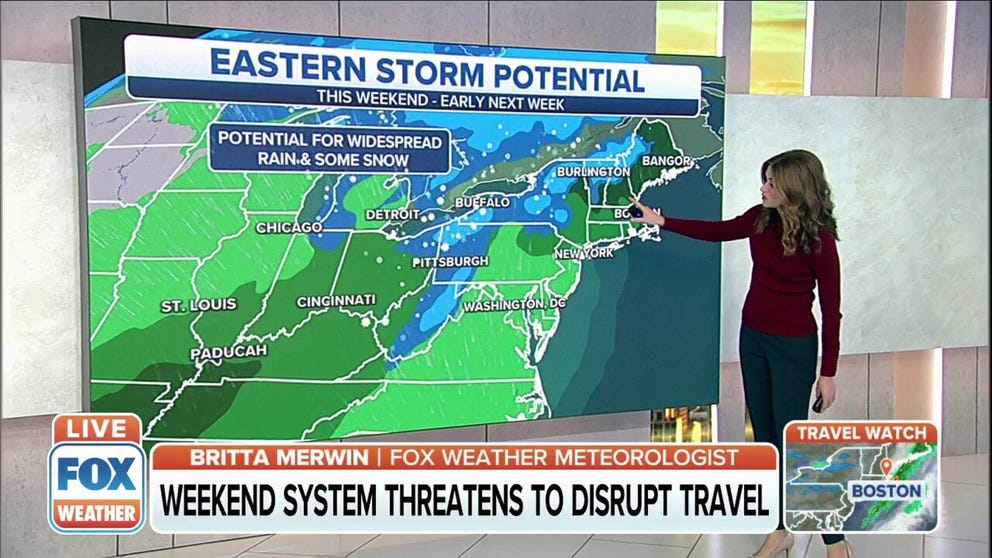
Early-week storm threatens to disrupt travel before Thanksgiving
An early-week storm that could produce rain or snow threatens to disrupt travel before Thanksgiving.
A storm system impacting the heavily populated Northeast and Midwest during some of the nation's busiest travel days of the year is certainly not the news these holiday travelers want to hear less than a week before Thanksgiving. Despite some headlines suggesting otherwise, FOX Weather meteorologists are not anticipating major impacts on holiday travel.
(FOX Weather)
"The general idea is that we’re not looking at a blockbuster event ahead of Thanksgiving," said FOX Weather meteorologist Mike Rawlins. "Major travel disruptions appear unlikely due to this storm."
THANKSGIVING TRAVEL FORECAST: WHERE HOLIDAY TRAVELERS CAN EXPECT FLIGHT DELAYS INTO NEXT WEEK
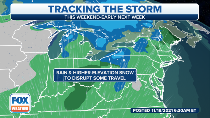
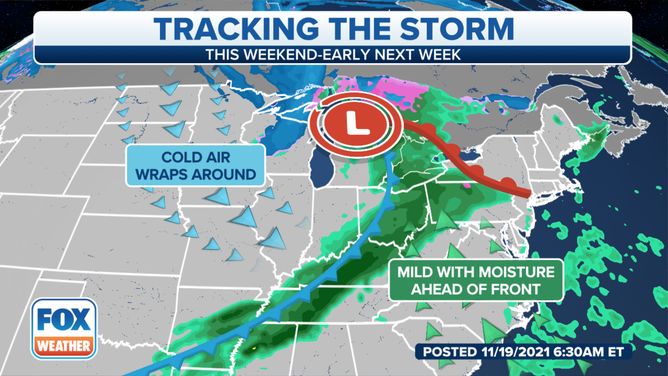
An area of rain will spread from the Midwest to the Northeast Sunday into Monday. Then, colder air arriving behind the storm system could result in a changeover to snow for interior sections of the Northeast.
(FOX Weather)
"Most places will just see rain, but colder air arriving behind the storm could result in a changeover to snow in the interior sections of the Northeast and the Great Lakes," Rawlins said. "For those traveling the Interstate 95 corridor from Boston to New York City to Washington, accumulating snow is unlikely."
Below, we'll take a closer look at the forecast for the Northeast and Midwest from Saturday night through Monday.
Saturday night
Showers will begin to develop over the Midwest on Saturday night.
Temperatures will be well above freezing, ranging from the upper 30s in Chicago to the mid-40s in the Ohio Valley, so the precipitation will all fall as rain overnight.
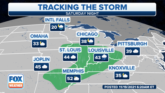
The forecast for Saturday night, Nov. 20, 2021.
(FOX Weather)
Sunday
The storm system will further organize over the southern Great Lakes, Ohio Valley and interior Northeast on Sunday, with rain showers predicted to develop in cities such as Buffalo, Cleveland, Detroit and Pittsburgh. Temperatures will be in the mid- to upper 40s in most areas, so no snow is expected.
A few rain showers are also possible along this system's cold front from eastern Texas to the mid-South, including in Houston, Nashville and Memphis, Tennessee.
FLYING THIS THANKSGIVING? PREPARE FOR PACKED FLIGHTS, BUSY AIRPORTS
However, with colder air quickly rushing in behind this storm, there could be snow showers in parts of the upper Midwest. Any snow accumulations are expected to remain on the lighter side.
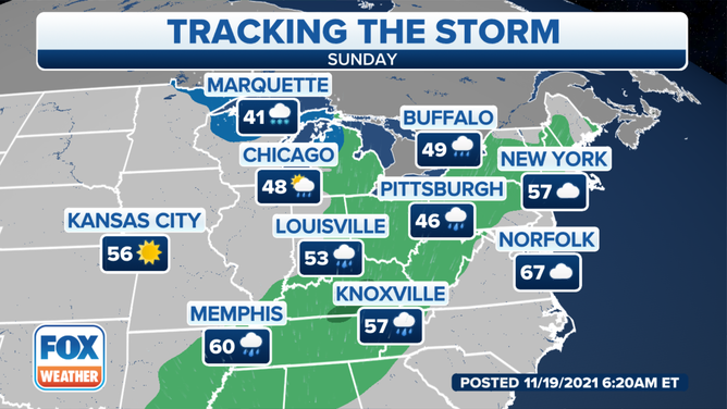
The forecast for Sunday, Nov. 21, 2021.
(FOX Weather)
Sunday night
Rain showers will continue spreading eastward toward the Northeast and mid-Atlantic Sunday night. Temperatures are expected to be in the 50s along the East Coast when the rain arrives, so there are no concerns for wintry weather.
Back to the west, strong winds will begin to develop on the backside of the storm across the Midwest as much colder air continues to filter in from Canada. This will result in the development of lake-effect snow across parts of Michigan as winds shift out of the northwest off lakes Superior and Michigan.
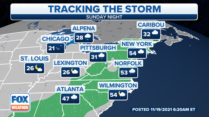
The forecast for Sunday night, Nov. 21, 2021.
(FOX Weather)
Monday
The storm system will continue to impact the Northeast on Monday, bringing rain showers from New England to the mid-Atlantic, including the Interstate 95 corridor from Boston to New York City to Washington.
TRAVELING THIS THANKSGIVING? PACK YOUR PATIENCE
Rain could change to snow in parts of the interior Northeast with the arrival of colder air behind the storm, while additional lake-effect snow develops in the Great Lakes snowbelts from Michigan to western and central New York.
Strong wind gusts will also remain a threat on the backside of this storm over the Great Lakes while also spreading into the Northeast and Southeast as the day progresses.
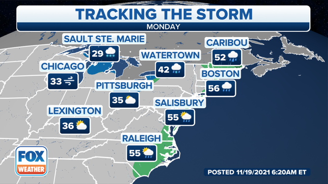
The forecast for Monday, Nov. 22, 2021.
(FOX Weather)
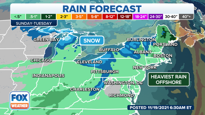
Rain and snow outlook
Rain amounts should remain under a half-inch in most areas from the Midwest to the Great Lakes, Ohio Valley, Northeast and mid-Atlantic.
A few isolated spots in Kentucky might pick up a half-inch or more due to enhancement from the terrain, but the heaviest rain is expected to stay offshore from the East Coast.
Most, if not all, of the snow from this storm system is forecast to be from the lake-effect snow that will develop in its wake.
While it's too early to make a prediction for snowfall amounts, it's possible that several inches could pile up in the typical Great Lakes snowbelt locations of northern Michigan, northeastern Ohio, northwestern Pennsylvania and western and central New York. The mountains of eastern West Virginia also have the potential to pick up a few inches of snow in the highest terrain.
Rain/snow outlook Sunday through Tuesday.
(FOX Weather)