Major winter storm to blast millions across the South with dangerous ice, snow from Texas to the Carolinas
People living and traveling across the Interstate 40 and 20 corridors should expect to see some kind of winter weather this weekend.

Dangerous winter storm brewing late week across the South, widespread snow and ice possible
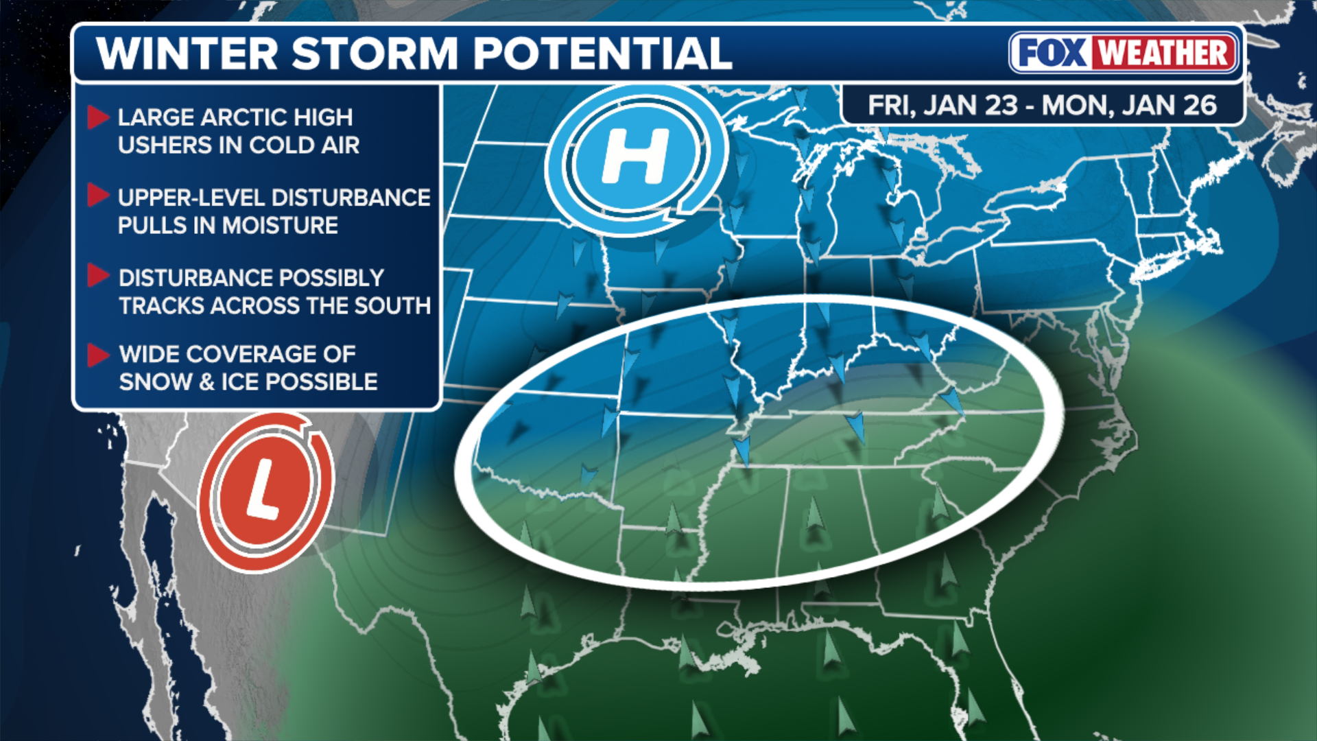
There's growing confidence among computer forecast models that a major winter storm will deliver widespread snow and ice across the South, beginning Friday and lasting through the weekend. The system will reach Texas sometime Friday and track through the Deep South and the Tennessee Valley before reaching the Southeast Coast. People living and traveling across the Interstate 40 and 20 corridors should expect to see some kind of winter weather. Exactly where snow, ice and plain rain will develop remains an open question, but those details will become clearer as we approach the weekend.
A major winter storm is expected to slam millions across the South with dangerous ice and snow from Texas to the Southeast Coast beginning Friday and lasting through the weekend.
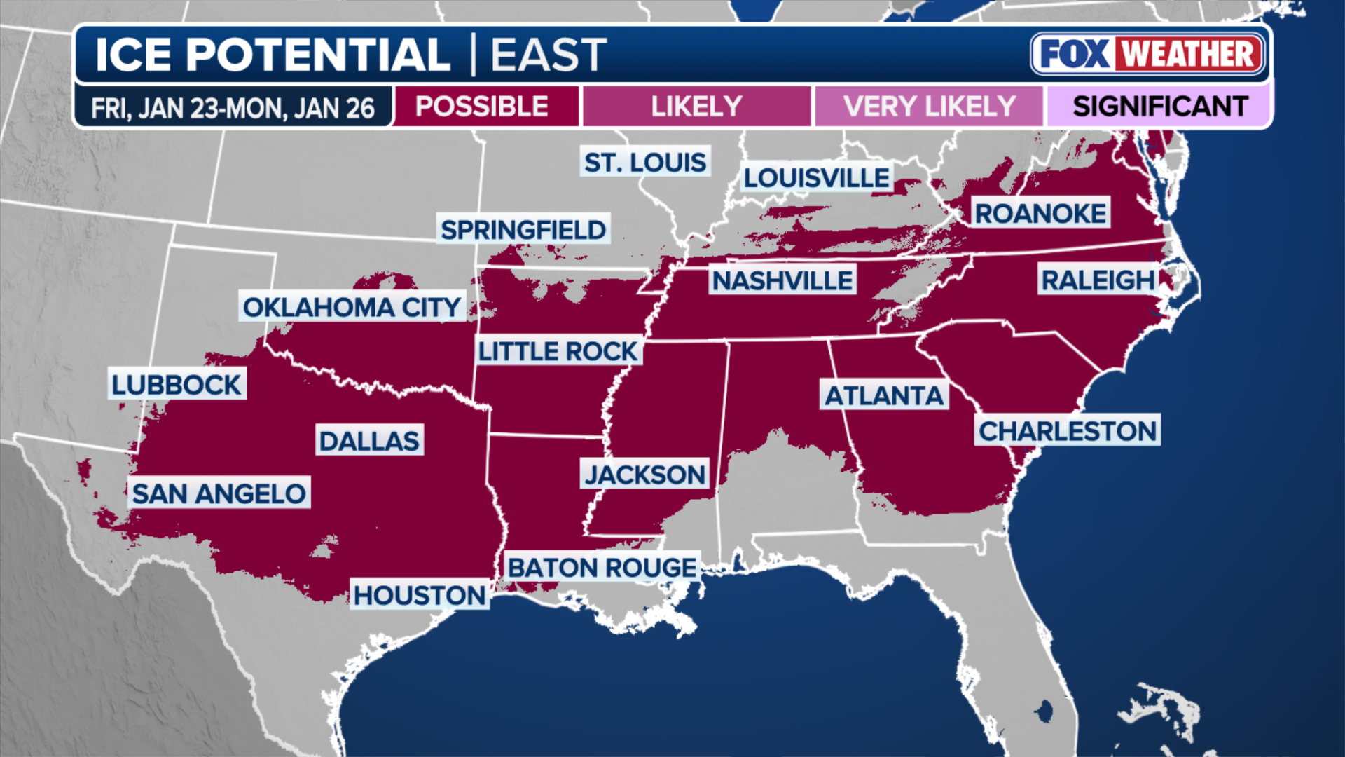
The first wave of Winter Weather Alerts has been issued for portions of Texas, Oklahoma and Arkansas from Friday night through Saturday. Heavy accumulations of snow and ice are possible, and Winter Weather Watches are in effect.

Winter Weather Alerts have been issued for parts of Texas and Oklahoma Friday night into Saturday.
(FOX Weather / FOX Weather)
The state of Texas has activated its state emergency response resources in anticipation of the winter storm. Governor Greg Abbott said this is being done to ensure Texans have the resources they need before severe winter weather moves in.
"As temperatures could drop below freezing and regions of Texas face snow, ice and freezing rain, it is crucial that Texans remain weather-aware, check DriveTexas.org before traveling, and heed the guidance of state and local officials," Abbott said in a statement.
WHAT ARE ICE STORMS AND WHY ARE THEY DANGEROUS?
The activation allows the state to bring in additional resources to ensure they're ready to respond to weather-related emergencies.
People living and traveling across the Interstate 40 and 20 corridors should expect to see some kind of winter weather.
![Light snow falls in Milton, FL over the weekend]() Image 1 of 4
Image 1 of 4Light snow falls in Milton, FL over the weekend. (Lee Chandler )
![Parts of Georgia are blanketed by heavy snowfall as a storm system passes through the area.]() Image 2 of 4
Image 2 of 4Parts of Georgia are blanketed by heavy snowfall as a storm system passes through the area. (Randall Duke)
![A winter storm system passes through parts of Georgia.]() Image 3 of 4
Image 3 of 4A winter storm system passes through parts of Georgia. (Alan Anderson)
![Snow covers a Florida beach after a snowstorm.]() Image 4 of 4
Image 4 of 4Snow covers a Florida beach after a snowstorm. (Ruth)


Exactly where snow, ice and plain rain will develop remains an open question, but those details will become clearer as we approach the weekend, when a system out of the Southwest will tap into widespread cold air that's expected to dominate much of the country this week.
This comes after parts of Florida, Alabama and Georgia saw rare snow accumulation over the weekend.
HOW COLD DOES IT NEED TO BE IN FLORIDA FOR IGUANAS TO FALL FROM TREES?
This marked the first time some places in the Panhandle have seen snow in back-to-back winter seasons.
(FOX Weather)
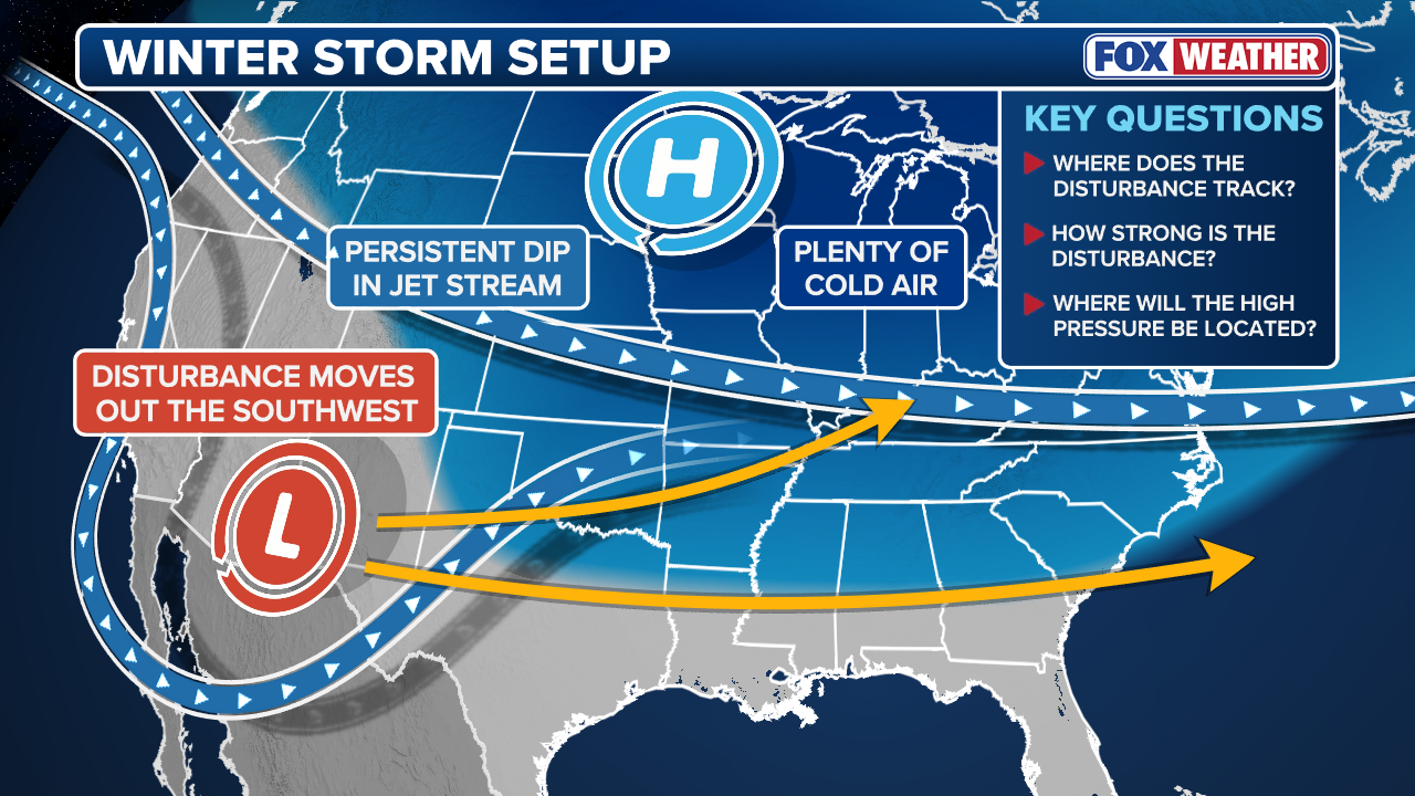
Several shots of Arctic air will spill across most of the Lower 48 this week due to a persistent dip in the jet stream.
This cold air will set the stage for the late-week winter storm brewing for much of the Southern Plains and Deep South.
The system driving the potential winter weather is forecast to move out of the Southwest sometime Friday or into the weekend.
(FOX Weather)
The southerly track of this storm will draw in moisture from the Gulf and create the potential for snow and ice.
However, the exact impact of this system will depend on its track and the amount of cold air in place, details that will become clearer later this week.
According to the FOX Forecast Center, several general outcomes are possible.
"Snow would likely develop north of the system’s track, rain would fall to the south, and a potentially impactful zone of ice could set up in between," the FOX Forecast Center said.
(FOX Weather)
Currently, the corridor that will likely see the greatest ice threat includes an area from Central Texas through the Lower Mississippi and Tennessee valleys and Carolinas.
(FOX Weather)
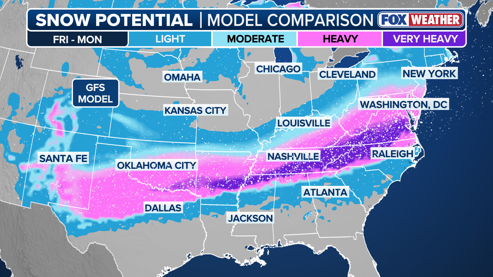
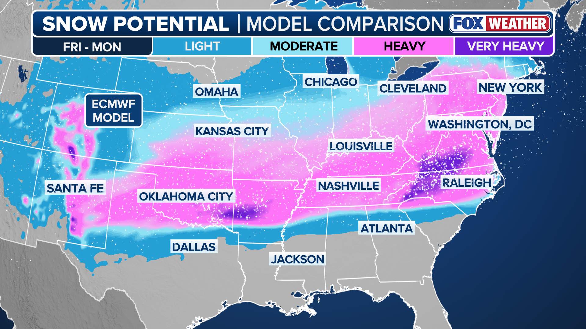
Meanwhile, both the American GFS and the European forecast models are currently in agreement that a swath of snow will fall from Oklahoma and the Texas Panhandle east through the Mid-Mississippi and southern Ohio valleys and possibly into the Mid-Atlantic.
(FOX Weather)
However, the European model is calling for more intense snowfall throughout this corridor.
Beyond the South, there is potential for this system to lift farther north and reach parts of the Northeast Coast or even evolve into a coastal storm next week, but there is currently no consensus on either of those outcomes.
Check back for updates on this developing story.