Winter storm wallops northern Plains bringing near record-setting snow to Bismarck
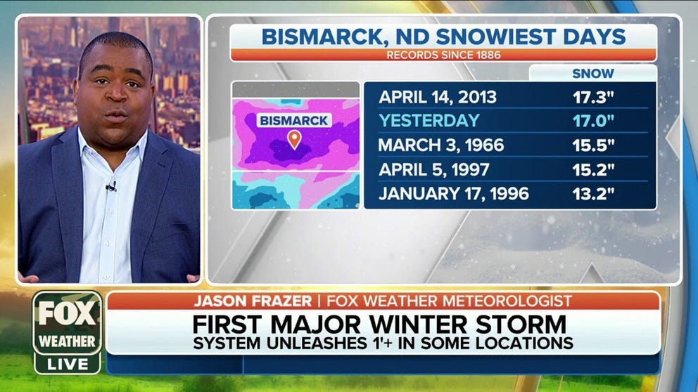
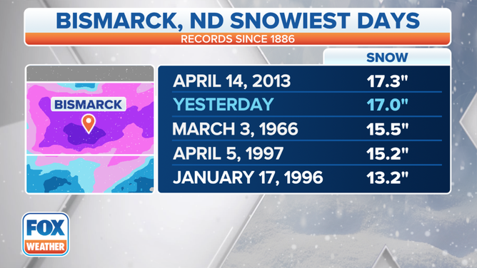
With 17 inches of snow Thursday in Bismark, North Dakota, the city recorded its second-snowiest calendar day since records began 134 years ago and was a fraction of an inch from setting their all-time record.
First blizzard of season blasts Bismark, ND with more than a foot of snow
This system will continue pushing east Friday into the Great Lakes region, where mostly rain is expected. Snow will wrap around the back side of the storm, with light snow expected to persist Friday morning in Minnesota and northern Wisconsin.
BISMARCK, N.D. – The season's first blizzard for the lower 48 states rolled through the Dakotas and the Upper Midwest this week.
Born from a system that brought heavy rains, mountain snows and powerful winds to the Northwest, the system eventually moved out of the Rockies late Wednesday and spread into the northern Plains on Thursday. As the cold air quickly filtered in, heavy snow, sleet and freezing rain fell across the region.
The FOX Forecast Center said snow totals quickly increased, with a foot of snow reported in Hanover, North Dakota.
With 17 inches of snow Thursday in Bismark, North Dakota, the city recorded its second-snowiest calendar day since records began 134 years ago and was a fraction of an inch from setting their all-time record. On April 14, 2013, 17.3 inches of snow fell over the city.
NEAR WHITE-OUT CONDITIONS REPORTED IN NORTH DAKOTA DURING SEASON'S FIRST MAJOR WINTER STORM
With 17 inches of snow Thursday in Bismark, North Dakota, the city recorded its second-snowiest calendar day since records began 134 years ago and was a fraction of an inch from setting their all-time record.
(FOX Weather)
Blizzard Warnings were in effect in central and northeastern North Dakota, north-central South Dakota and northwestern Minnesota for Thursday for not only heavy snow, but severe winds to 40 mph and low visibility. A 200-mile stretch of Interstate 94 in North Dakota was closed for much of Thursday due to whiteout conditions.
In the transition area between the snow to the north and rain to the south, some pockets of freezing rain and sleet fell, though power outages were minimal.
WHAT MAKES A BLIZZARD DIFFERENT FROM AN ORDINARY SNOWSTORM?

(FOX Weather)
System moves into Great Lakes Friday
This system will continue pushing east Friday into the Great Lakes region, where mostly rain is expected. However, snow will wrap around the back side of the storm, with light snow expected to persist Friday morning in Minnesota and northern Wisconsin and Winter Weather Advisories lingered.
HERE'S WHY 'BLIZZARD ALLEY' IS IN THE NORTHERN PLAINS
By Friday afternoon, most of the snow will move north of the border into Canada, though some lake-effect snows in the usual spots, such as the Upper Peninsula of Michigan, Northwest Michigan, and the Eastern shores of Lake Erie and Ontario.

(FOX Weather)
Snow amounts will range from 3-5 inches, which while not significant for that region, could lead to some travel impacts on roads. These lake-effect snow showers are expected to end on Monday.