Deadly flooding triggered by record rainfall in Los Angeles as feet of snow pile up in mountains
A messy week of weather has returned to the West as two separate storm systems combine with cold fronts to bring heavy rains, significant mountain snows and damaging wind gusts, with the possibility for widespread and dangerous impacts.

Ten people were washed away by flooding in southern California
The Ontario Fire Department searching for 2 missing homeless people washed down a flood channel. They were able to rescue 3 who are recovering at a hospital. Another person died.
ONTARIO, Calif. – One person is dead after a significant storm brought heavy rain and flooding to Southern California.
The significant storm brought widespread impacts to the Golden State Tuesday and is expected to continue into Wednesday. Several inches of mountain snow and torrential rains are forecast throughout California.
Southern California saw record rainfall for multiple sites across the region Tuesday. In Sandberg, 3.62 inches of rain was recorded, breaking the old daily rainfall record of 0.43" set back in 2002.
According to Ontario officials, one person died, and five others were injured after the 10 were swept downstream by floodwaters. Crews are still searching for 4 missing people.
Golden State goes gray
Generally, rainfall totals are expected to range between 1 and 3 inches in the California lowlands, though heavy rains in burn-scar areas of Southern California have triggered flooding and debris flow problems.
HOW WILDFIRE BURN SCARS COULD HAVE LASTING IMPACTS
Orange County officials ordered evacuations for Silverado Canyon, Williams Canyon and Modjeska in the Bond Fire burn area due to possible debris flows. Orange County Public Works reported some roads in the area covered in water, mud and other debris from torrential downpours.
Farther east, in San Bernardino County, rainfall totals of 3 to 5 inches were triggering several reports of flooding, debris flows and road closures.
Officials evacuated one polling place in San Bernardino due to the heavy rain and flash flood threat, according to FOX 11 Los Angeles.
California Highway 38 was closed due to mud, rockfall and debris on the roadway, according to CalTrans, while Green Mountain Road was covered in boulders and debris amid 4.4 inches of rain. Similar rain totals left parts of Highway 138 covered by water and debris, while Highway 18 was closed due to flooding near California State University-San Bernardino.

LOS ANGELES, CA - NOVEMBER 8, 2022 - The rain seems to have created a natural car wash in Los Angeles.
(Genaro Molina / Los Angeles Times / Getty Images)
Two cars became stuck in floodwaters along Highway 2 at Sheep Creek Drive, and other cars were reported stranded for a time as some roads washed out near Mt. Baldy. A rock slide along Highway 330 blocked both lanes as rainfall rates reached 0.40 inches per hour, while Arroyo Canyon reported double the rainfall intensity of 0.30 to 0.40 inches per 30 minutes. Officials were hopeful the heavy rains would likely end the fire season in the Golden State, making it the second-least active season in the past decade.
But heavy rains even caused problems closer to Los Angeles, where nearly 2 inches of rain was expected by the storm's end. A slide spilled mud onto multiple lanes of California's Highway 60 near its connection to the Interstate 10 freeway in Los Angeles.
Other highways suffered flooding due to drain blockages.
Winds have been quite blustery in Southern California with a gust to 80 mph at Lytle Creek, 72 mph in Big Bear City, 65 mph at Lake Arrowhead and 58 mph in Palmdale. Closer to the Los Angeles and San Diego metro areas, wind gusts of 25 to 45 mph were reported. Wind Advisories are in effect into Wednesday.

(FOX Weather)
Farther north, in the Bay Area, rainfall totals of more than an inch flooded roads and freeways, especially in the South Bay.
Wind Advisories stretch north into the coastal Bay Area, where even San Francisco is under alert for gusts to 40 to 45 mph.
Thunderstorms are dropping heavy rains, triggering several Special Marine Warnings for boaters along and off the Central California coast with strong wind gusts, lightning and possibly waterspouts. A funnel cloud was reported in Napa County late Tuesday morning.
Galt, California, actually had an EF-0 tornado plow through almost a mile, the National Weather Service confirmed. The twister blew off a barn roof, downed power lines and blew out bus windows.
Whiteout conditions in Sierra Nevada
Up in the mountains, heavy snows have been falling since the start of the week, including in the Sierra Nevada, where storm totals of 1 to 4 feet of snow are expected above 4,000 feet in elevation.
Already, 17 inches of snow had fallen at Kingvale over the past three days – 11 inches just within 24 hours – with 15 inches at Donner Peak, 14 inches at Soda Springs and 16 inches at Palisades Tahoe. In addition, wind gusts between 40 and 55 mph amid heavy snow are producing whiteout conditions, and travel across the mountains will become extremely hazardous – if not impossible.
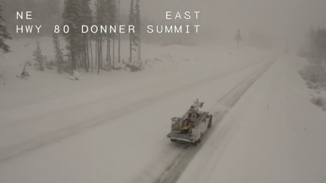
Heavy snow atop Donner Summit along Interstate 80 in California on Nov. 8, 2022.
(CalTrans / FOX Weather)
"Travel is highly discouraged" due to road closures, chain requirements and whiteout conditions, the National Weather Service office in Sacramento said.
Chains remain required across multiple highways along the Sierra, including Donner Pass on Interstate 80, where 24 to 36 inches of new snow is expected through Wednesday.

(FOX Weather)
"If you don't need to be out on the road… it's best to just stay home and enjoy some hot chocolate," the National Weather Service office in Reno, Nevada, said. "Chain controls are plentiful."
Winter driving conditions extended into both the Northern California and Southern California mountains.
In Northern California, Winter Storm warnings were in effect for the Mount Shasta area for as much as 1 to 2 feet of snow. The northbound lanes of Interstate 5 were closed for several hours Monday night at Fawndale just north of Redding due to heavy snow. The freeway reopened early Tuesday morning, with officials spot-checking each vehicle for chains before allowing them to proceed, only to shut down again later in the day due to additional crashes and spinouts.
To the south, Winter Storm warnings remained in effect for the mountains of Los Angeles, Ventura, Riverside and San Bernardino counties as 8 to 14 inches of snow – with isolated areas of up to 20 inches – was expected above 6,000 feet. Strong winds gusting as high as 65 to 75 mph along the mountain peaks will make for blowing snow and reduced visibility.

(FOX Weather)
"The way I look at it is: If you have a Winter Storm Warning in effect, that’s when I take a pause," said FOX Weather meteorologist Britta Merwin. "When you have a (Winter Weather) Advisory, you definitely want to make sure you know what you are getting yourself into; you want to allow for that extra drive time, but I wouldn’t completely cancel your plans. You just really need to look into what you’re getting yourself into. A Winter Storm Warning – that’s when I would suggest waiting until the warning has let up because you’re going to have visibility issues. You’re also talking about more than 6 to 8 inches of snow."
According to the FOX Forecast Center, rain and heavy mountain snow will persist through Wednesday.
"We’re not going to see improvements until the middle of the week, so that’s what you evaluate here is how much time do you have to play with," Merwin said. "We are looking at a substantial snow for the Sierra Nevada, especially in the higher elevations."
Coldest weather of season for northern Rockies
In Nevada, strong winds and blowing snow amid gusts of 65 mph or higher will be the main concern for the lower elevations as rain amounts are expected to remain on the lighter side.
WHAT YOU SHOULD KNOW ABOUT BLOWING, DRIFTING SNOW
The storm's impacts will be more widespread in the higher mountains, especially in western Nevada, where significant snow will be possible. Falling trees and limbs could lead to power outages due to the gusty winds and snow. Temperatures will tumble as cold air arrives behind the weather system.
In the northern Rockies of Montana and Idaho, the coldest air of the season moved in on Monday and is expected to last through most of the week.

(FOX Weather)
"This will lead to potentially dangerous conditions for those caught unprepared," FOX Forecast Center meteorologists said.
On the precipitation side, widespread mountain snow is expected, with travel impacts in the passes likely.
Feet of snow in Utah mountains
Heading south into Utah, significant snow is expected in the mountains through Thursday.

(FOX Weather)
Precipitation developed on Monday and will continue in multiple rounds through Thursday, strengthened by numerous atmospheric rivers.
Forecasts call for 1 to 2 inches of rain, though the mountains could see more than 1 to 2 feet of snow along with winds gusting over 60 mph.