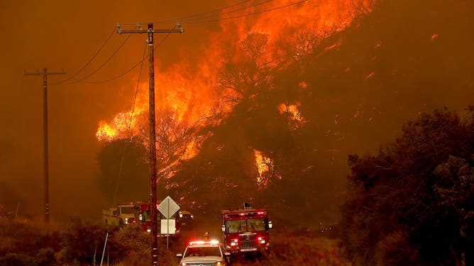
Widespread western wildfires plus winter weather: A dangerous setup for deadly debris flows
Burn scars leave land susceptible to landslides and debris flows which can take out not only homes but whole communities
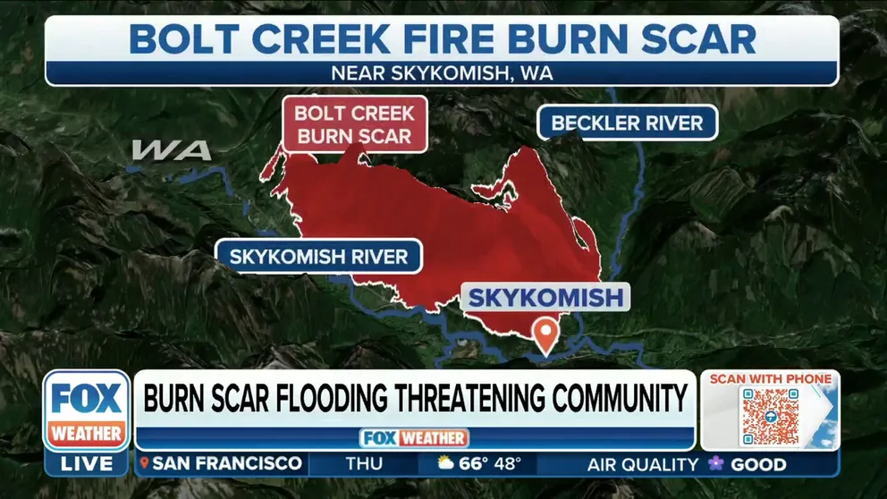
With winter looming, Bolt Creek Fire's burn scar could lead to debris flow
Brendan McCluskey, Director of King County Office of Emergency Management, talks about the concerns of the Bolt Creek Fire's burn scar leading to flash flooding.
Wildfire dangers are not over once the fire is out. Winter storms bring another risk, as burn scars from the enormous summer fires leave nearby communities at risk for sudden and deadly debris flows.
Burning trees and other vegetation release soil-sealing wax making the ground almost waterproof across a burn scar. Burned land is barren vegetation with roots that bind the soil, preventing erosion.
"In places where the wildfire was burning for a while, the soil afterward almost repels the water. Rainfall that would normally be absorbed, especially in dense forests, will very quickly run off and pose a threat for extreme flash flooding for whoever or whatever is down the mountain," Meteorologist Heather Brinkmann said.
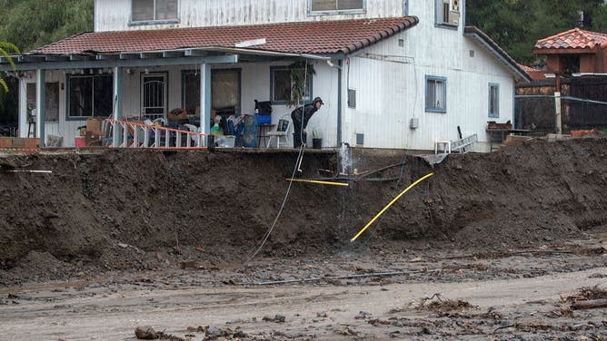
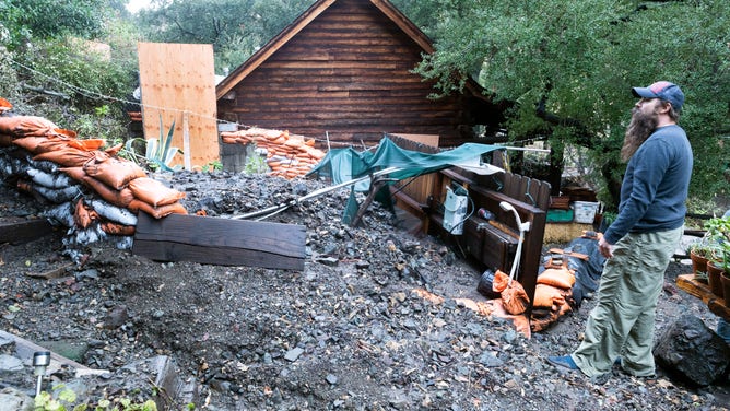
A man peers over the edge of the porch of a home's foundation that has been undermined along with a shed and trees taken by heavy flood water and debris flowing down Leach Canyon flood control from the nearby Holy Fire burn scar behind homes.
(Allen J. Schaben/Los Angeles Times / Getty Images)
Fire also burns trees and roots, leaving behind hundreds of acres of fallen tree trunks that can easily be picked up by flash flooding to create a debris flow.
The USGS says as little as 0.3" of rain in 30 minutes to trigger a debris flow during an area’s first post-fire burn. A burn scar can take several years to recover. Most debris flows occur in the first 2 years after a fire.
Burn scars, debris flows and impacts on the West
"Everything is compromised. It's not like there's a healthy grove of trees that's going to stop the debris flow," Katie Sterling, a homeowner near the Bolt Creek Fire burn scar in Washington, told FOX 13 Seattle. "You hear one tree pop and fall. And usually, that's all you hear is one tree fall. But now it's like one tree falls, and then a whole bunch more stuff falls down with it."
After a wildfire scorched plants lay down a wax making the ground almost waterproof. Loose debris can easily be part of a debris flow.
(Carlos Avila Gonzalez/The San Francisco Chronicle / FOX Weather)
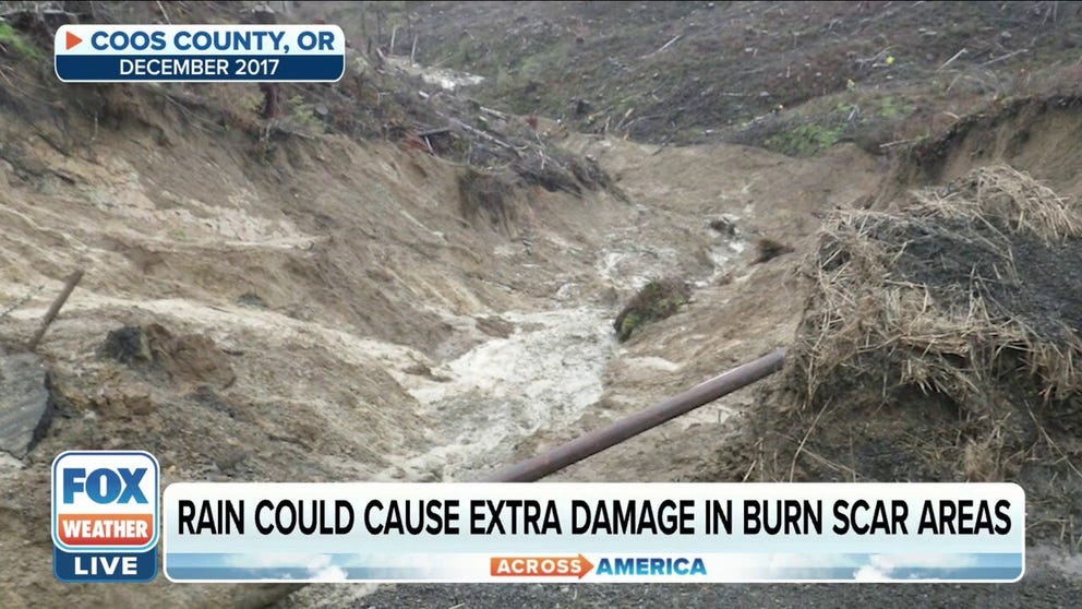
The first of a round of strong storms brought heavy rain and thunderstorms to the foothill communities of the Cascade Mountains burn scars. Community leaders held town halls warning residents.
"We were really concerned about fire debris that comes down after the hillsides and blocks the roads," explained an emergency manager at the meeting. "We started seeing it in the middle of the fire where firefighters were almost killed."
Oregon residents living near wildfire-impacted areas on alert during rainy season
Oregon Emergency Management Deputy Director Stan Thomas discusses the increased risk of flooding near burn scar areas and tells FOX Weather how residents can prepare for wet conditions.
Widespread fires across Western states could set millions up for a dangerous winter. Meteorologists are already calling for a La Nina weather pattern to be in control this winter which could mean a wetter than normal year for the Northwest with more atmospheric river fueled-storms.
The Fairview Fire burning forest near Hemet, California in September.
(Luis Sinco / Los Angeles Times / Getty Images)
We already had a preview this summer of what could happen when heavy rain hits burn scars.
Video caught a debris slide destroying a restaurant as 7 feet of boulders, mud and tree trunks swept through. Monsoon rain fell on a southern California burn scar.
"The size of a burn area and the severity of the burned area are both closely related to debris flow hazard levels," said Daniel Horton, professor of Earth and Planetary Sciences at Northwestern University. "Generally speaking, higher burn severity, higher debris flow hazard. Larger the burn area, larger the downstream areas that are affected."
Monsoon rains also fell over the burn scar of the largest wildfire in New Mexico’s history this summer. The debris flows and runoff polluted an entire town’s water source.
POLLUTION FROM FED-SPARKED WILDFIRES LEAVES NEW MEXICO TOWN WITH UNDER 50 DAYS OF WATER
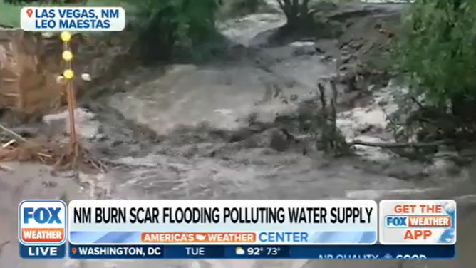
Drought-stricken Las Vegas, New Mexico gets inches of water from thunderstorms. But, the water is polluted by ash and soot from recent fires.
(Leo Maestas)
Horton calls debris flows a "slurry," mix of water and dirt, boulders, trees, sand and anything else in its path.
"Debris flows are very dangerous and have been known to destroy roads, homes, and other structures and result in fatalities if people are not able to evacuate," said Horton. "Debris flows speeds vary depending on the event, but can reach up to 35 mph."
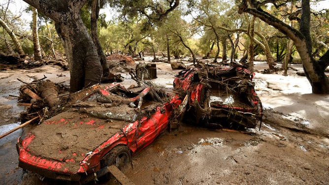
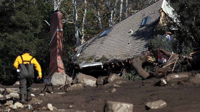
The U.S. Geological Survey states that 25-50 people in the U.S., on average, are killed by landslides which cause up to $2 billion in damage every year. One of the most tragic flows killed 23 people, injured 167 more and damaged over 400 homes in Montecito, California, in January 2018. Heavy rain fell on the Thomas Fire burn scar in the upscale Santa Barbara County community.
HOW TO WATCH FOX WEATHER ON TV
![]() Image 1 of 2
Image 1 of 2Cars were thrown and twisted by the debris flow. (Wally Skalij/Los Angeles Times)
![]() Image 2 of 2
Image 2 of 2MONTECITO, CA - A home sits on its side after the deadly debris flow, (Justin Sullivan)
"We're worried about the rain, the winter and (will be for) a couple of years down the road," Brendan McClusky, director of King County, Washington Emergency Management told FOX Weather Thursday about keeping the public informed. "We've had people go door to door with information, and now, in addition, we're giving them some NOAA all-hazard weather radios. And we're even going to be putting some portable weather stations on top of the mountain there so that we can accurately track what the rainfall rates are."
What's being done to prevent debris flows on burn scars?
SILVERADO, CA - Three feet of mud filled in a hot tub and partially buried this man's house after rain on a burn scar triggered a debris flow.
(Paul Bersebach/MediaNews Group/Orange County Register / Getty Images)
Drought compounds wildfire, flash flooding, and debris flow dangers. Western states are currently in a mega-drought, the worst in 1,200 years, according to scientists.
"Drought increases the risks of wildfire. Secondly, drought can cause a hyper-dry condition in the soil, which induces ‘soil-water repellency,’" Chuxuan Li, Northwestern Ph.D. candidate, said. "This means the soil is so dry that it cannot absorb any water when the first big storm arrives, which in turn increases the likelihood of flash flooding and debris flows."
Horton and Li developed a computer model to forecast debris flows in burn scar areas. They published a study demonstrating the tool focusing on last winter’s atmospheric fuels storms that fell across the iconic Pacific Coast Highway near Big Sur, California. Rain on the scar caused a debris flow which knocked a section of the road into the sea.
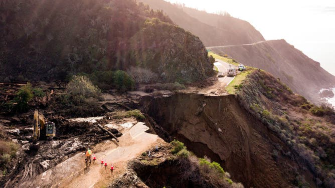
A debris flow from rain on a burn scar washed out 150-feet of Pacific Coast Highway in Big Sur, California in 2021.
(JOSH EDELSON / AFP / Getty Images)
"Ultimately we’d be thrilled if the model were able to help operationally forecast areas of high debris flow likelihood, and therefore help save life and property," Horton and Li said.
They said the model is a prototype. But, once operational, it can help the National Weather Service and the U.S. Geological Survey to put out early warnings and hopefully lead to preventive land management techniques.