Powerful nor'easter slamming Carolinas on path to Northeast threatening 'major' coastal flooding, 60-mph winds
The Carolinas are the first stop on the nor'easter's multiple-day journey north along the Atlantic Seaboard, as the strengthening storm will energize Sunday and threaten the mid-Atlantic with major coastal flooding and damaging wind gusts.

Powerful nor'easter charging up off East Coast
A fall nor'easter is strengthening off the East Coast, expecting to bring impacts from the Carolinas to New England. New Jersey could see major coastal flooding with levels as high or higher than with Superstorm Sandy in 2012.
BUXTON, N.C. – A powerful nor’easter off the Carolinas Saturday is giving weary Outer Banks residents more anxious moments as the Atlantic Ocean surges inland amid heavy rains.
It's just the first stop on the storm's multiple-day journey north along the Atlantic Seaboard, as the storm will energize on Sunday and threaten several states across nearly 500 miles of the mid-Atlantic and Northeast with major coastal flooding and damaging wind gusts.

(FOX Weather)
Steady rains are already soaking the Carolina beaches on Saturday morning, with blustery winds set to increase in gusts to 35-50 mph, according to the FOX Forecast Center. The persistent onshore winds are bringing yet another round of heavy surf, triggering 2-4 feet of coastal flooding to areas along the Outer Banks still reeling from multiple high surf events through the past few weeks.

Powerful nor'easter to smack Carolinas with heavy rain, damaging winds
The worst of the impacts from a powerful fall nor'easter are hanging off the coast for now, but is expected to bring rough surf, coastal flooding, heavy rain and damaging winds to areas like Charleston. FOX Weather Meteorologist Bayne Froney reports from Charleston on Saturday morning, where strong winds and light rain were starting.
Rodanthe and Buxton lost nine beachfront homes to the encroaching surf earlier this month and several more are teetering on collapse.
NOR'EASTER LIVE MAP TRACKER: RADAR, STORM ALERTS, WIND FORECASTS:
"If you are located in an area with vulnerable dune structures, be ready to take action to protect property from ocean overwash," Dare County (N.C.) officials warned. "If you are standing at ground level and there is little to no dune between you and the ocean, you are in a vulnerable area."

North Carolina coastal flooding causes another home to collapse
Another house in Buxton, North Carolina, has been added to the list of destruction as the effects of Post-Tropical Storm Imelda have destroyed an additional home.
North Carolina's Highway 12, which is the lifeline to traveling on the Outer Banks, may also have to close again due to flooding.
Meanwhile, rounds of downpours will continue to pivot inland as the nor'easter slowly moves north into late Saturday night. Rain totals will amount to a widespread 2-3 inches, with locally higher amounts across the Outer Banks of 3-5"+ possible through Sunday, increasing the threat of flash flooding.
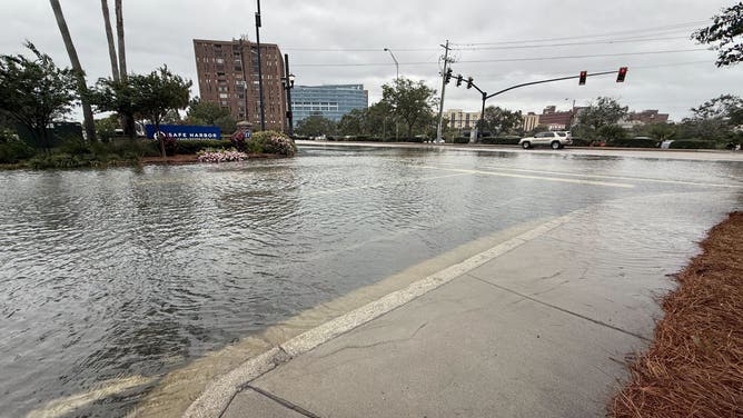
Flooded roads in Charleston, South Carolina on Oct. 10, 2025.
(FOX Weather)
South Carolina will also see another day of coastal flooding in spots on the heels of Friday's tidal surges that covered parts of Charleston for hours during high tide.
Nor'easter's set to slam the mid-Atlantic Sunday with powerful winds, 'major' coastal flooding
The storm's impacts spread north on Sunday to the coastal Mid-Atlantic states and Northeast. Of primary concern are coastal flooding and potentially damaging wind gusts, with heavy rains a factor too.
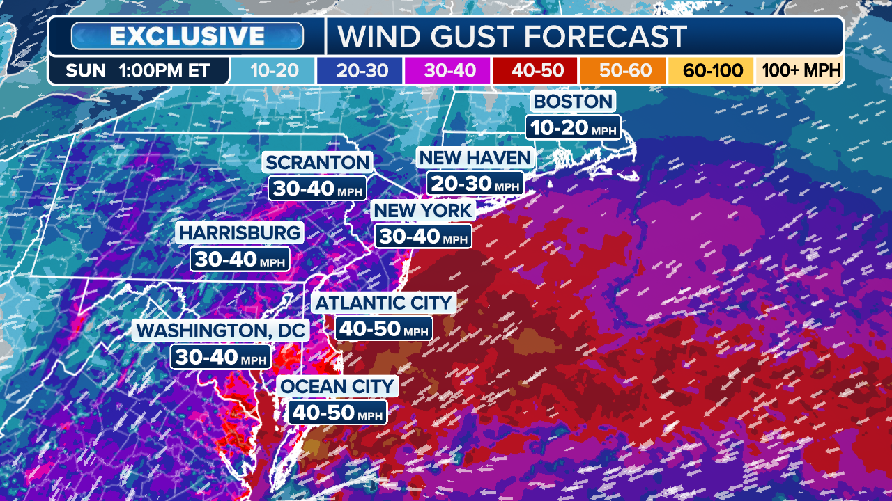
By Sunday morning, the center of the nor'easter will be somewhere close to coastal Virginia. High Wind Watches remain in place from Long Island through coastal New Jersey and Delaware for gusts up to 60 mph, lasting into Monday morning.
(FOX Weather)
As winds remain out of the northeast and wave heights build, coastal flooding will also be an issue from Virginia through New England.
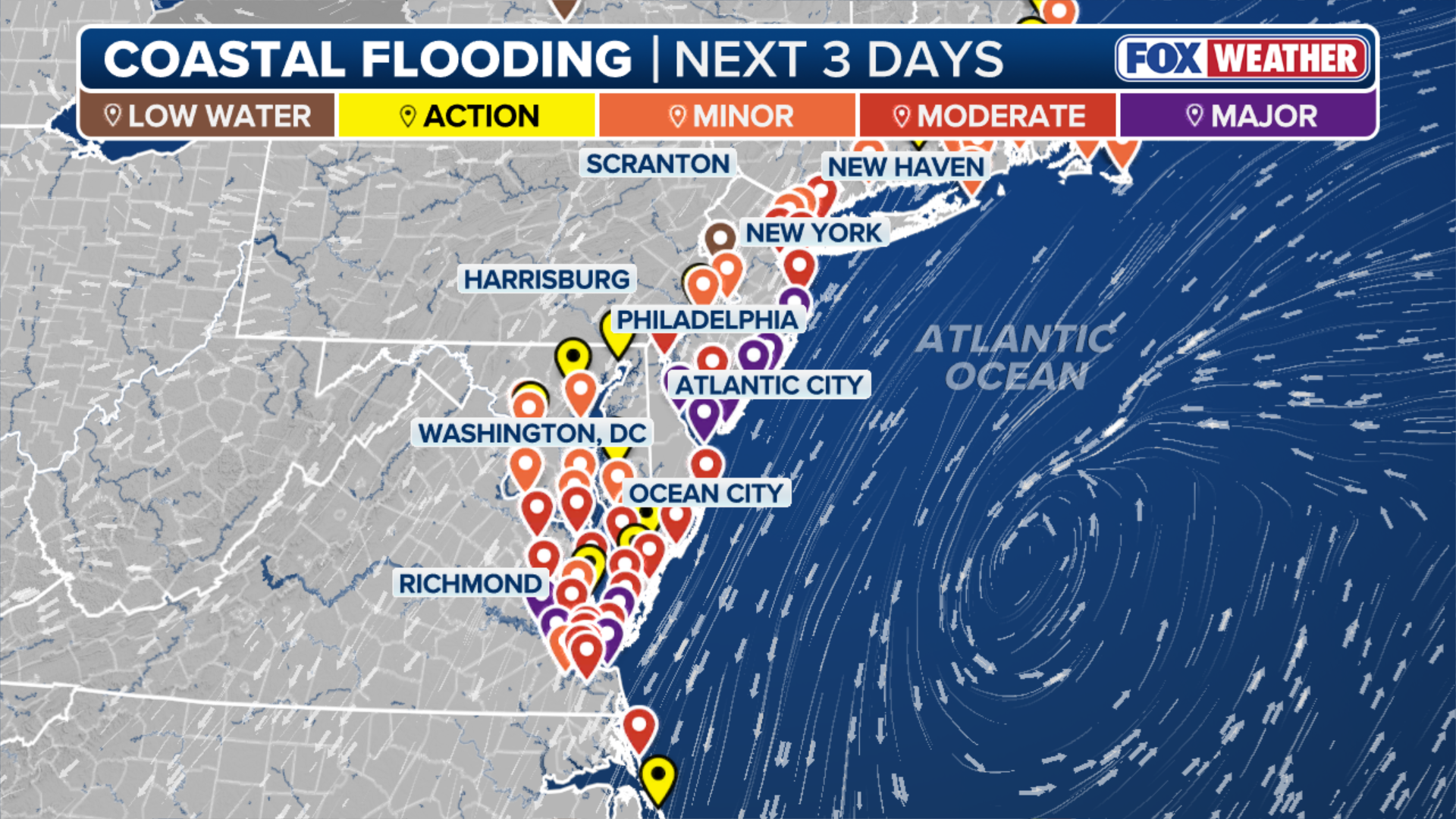
Over 25 million people remain under Coastal Flood Alerts along a 500-mile stretch across much of the mid-Atlantic and Northeast coasts through Boston through Monday. But concern is growing for major impacts along parts of Long Island, the New Jersey and Delaware coast, plus the Virginia Tidewater area. Some water level forecasts for southern New Jersey and Delaware may rival among the highest on record.
"Moderate to Major coastal flood impacts are increasingly likely," National Weather Service forecasters in Mount Holly, New Jersey wrote. "Widespread roadway flooding and impassable roads, inundation of structures, and evacuations are possible Sunday-Monday. Significant beach erosion and dune breaching is possible due to very high surf."
(FOX Weather)
Acting New Jersey Governor Tahesha Way says all 21 counties in New Jersey are in a statewide emergency starting midday Saturday due to the storm's threat. The declaration will help speed up emergency services and free up more resources for storm preparations and response.
Heavy rain will also increase the risk of flash flooding. A widespread 2-3 inches of rain is possible along the coast through Tuesday with isolated higher amounts.
"There's going to be huge disruptions if this forecast works out anything like this. Huge disruptions to everything in the Tri-State area here," said FOX Weather Hurricane Specialist Bryan Norcross. "All three (New York area) airports, Boston-Logan; it's just going to be a mess because these winds coming in with this velocity at this angle, it's just going to be very difficult to operate anything up there."

(FOX Weather)
And Norcross noted the winds would be piling water up at the coast.
"(It will be) pushing water into New York Harbor, pushing water into Barnegat Bay and the other bays and rivers and inlets that are along the Jersey shore, not to mention up here in New England. And then on Tuesday, it weakens and kind of moves away."
Nor'easter's effects linger into the start of the workweek in the Northeast
Into Monday morning, heavy rain and gusty winds will still largely be at play anywhere from the Atlantic City to Boston, the FOX Forecast Center says. Coastal flooding will have likely peaked on Sunday when the winds were the strongest, but even minor-to-moderate coastal flooding will be in play.
Some of the Jersey Shore may dry out later in the day Monday, but from Long Island to Boston should prepare for a washout and overall raw, blustery day.