Bryan Norcross: Major coastal storm forecast to impact most of the East Coast
A non-tropical area of low pressure is developing near the Central Florida east coast along the cold front that's pushing south. The low and its associated dip in the jet stream are in the configuration that often produces strong nor'easters along the Mid-Atlantic coast up to New England in the winter.

Nor'easter set to pummel Atlantic Seaboard from Carolinas to New England through the weekend
High wind and coastal flood alerts are in effect for millions up and down the Atlantic Coast as a nor'easter takes shape Friday and crawls north just offshore the next several days.
Updated 9:30 a.m. on Friday, Oct. 10, 2025.
A non-tropical area of low pressure is developing near the Central Florida east coast along the cold front that's pushing south. The low and its associated dip in the jet stream are in the configuration that often produces strong nor'easters along the Mid-Atlantic coast up to New England in the winter.
This is not a developing tropical storm because it's connected to the front that divides the cool Canadian air to the north and the moist tropical air to the south. It's that contrast that is powering the developing storm much more than the energy gained from the warm ocean.
The low is forecast to begin its move to the north tomorrow. Meanwhile, the strengthening low will whip the cold front through South Florida by tomorrow night, heralding a change in the season.
Over the Atlantic, winds behind the front are quite strong, driven by a robust high-pressure system over the Northeast. Those winds will push the ocean water against the Southeast coast causing moderate to major flooding. Significant saltwater flooding at high tide is forecast for Charleston beginning today, to pick just one location.
The storm looks likely to intensify through the day tomorrow so that by late tomorrow and overnight into Sunday, northeast winds peak over the very vulnerable Outer Banks of North Carolina and nearby waters. Tides are predicted to run 2 to 4 feet above normal causing the ocean to overwash vulnerable spots. A coastal storm of this type is called a nor'easter because the worst weather comes on those northeast winds. Coastal flooding, beach erosion, and winds gusting over 40 mph are likely if the storm develops as predicted.
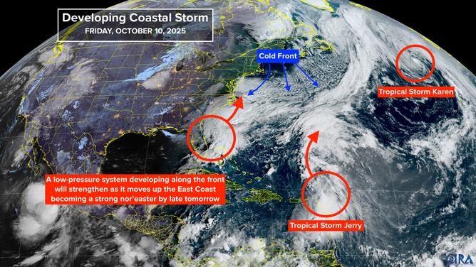
Satellite overview of the Nor'easter, Tropical Storm Jerry and Karen.
(Bryan Norcross / NOAA)
Winds will further increase from the east and northeast from the Mid-Atlantic to New England late Saturday and Sunday. Wind gusts to at least 60 mph capable of knocking out power are forecast along the coast. Coastal flooding is likely with tides running up to 3 feet above normal. Wind-driven rain and cool temperatures will make conditions especially nasty.
Current projections keep the storm in place through Monday – pounding the Jersey Shore, Long Island, NY, and coastal New England. By Tuesday, the system is forecast to weaken and drift southeast, away from the coast.
This will be an extended period of damaging and dangerous weather right along the coast. Air travel is likely to be seriously disrupted in the Northeast.
The National Weather Service is issuing high wind and coastal flooding alerts for a large part of the East Coast. Stay aware of the latest forecasts and warnings for your area.
There is some chance that the storm could sit over the warm water off the Carolinas long enough on Tuesday to shed its front and acquire some tropical characteristics and get a name, which would be Lorenzo.
In the Central Atlantic
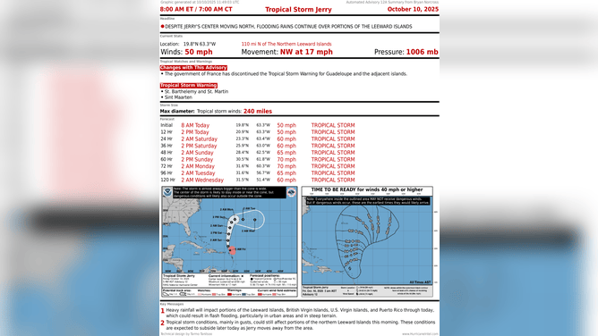
Tropical Storm Jerry
(Bryan Norcross / NOAA)
Tropical Storm Jerry has passed the northeast Caribbean, though its moisture tail is still affecting the islands. Rainfall could cause flooding in some areas. Up to 4 inches of rain is forecast over the islands from the Virgin Islands to the east, with up to 6 inches on Barbuda. This storm will curl out to sea over the weekend missing Bermuda by a good ways.
In the Northeast Atlantic
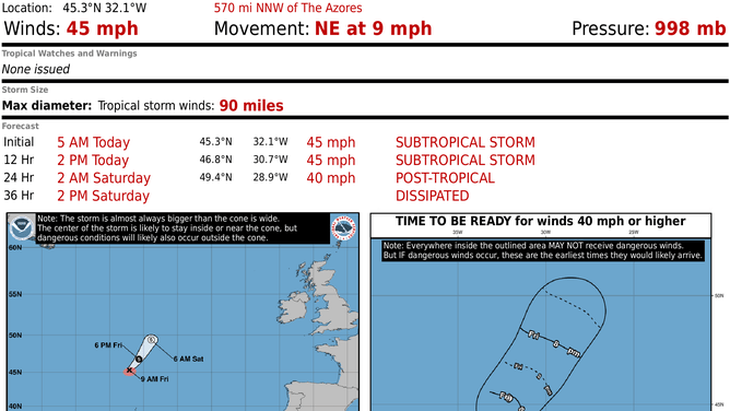
Subtropical Storm Karen
(Bryan Norcross / NOAA)
A robust non-tropical storm developed into Tropical Storm Karen. It’s going to be a flash in the pan, with the system forecast to dissipate tomorrow. This is the farthest north and east that any named storm on record has formed.
Otherwise, nothing is cooking, and the weather pattern looks hostile across the tropics for the next week or two.