NOAA's 3-month outlook has El Nino's fingerprints with mild North, rainy Southeast
The CPC says El Nino conditions are continuing with sea surface temperatures remaining above average across the central and eastern equatorial Pacific Ocean, and those conditions will likely persist through May.
El Nino played key role in 2023's wild weather
Pedro DiNezio, associate professor of Atmospheric and Oceanic Sciences at the University of Colorado Boulder, joins FOX Weather as we look back at a year of intense weather and climate.
NOAA’s Climate Prediction Center (CPC) released its three-month temperature and precipitation outlook on Thursday, and climatologists are warning that El Niño conditions are ongoing with those conditions likely affecting weather patterns across the U.S. through the end of April.
Sea surface temperatures are remaining above average across the central and eastern equatorial Pacific Ocean, triggering El Niño, and those conditions will likely persist through May.
That’s when the CPC says El Niño could transition to neutral conditions later this spring and into the summer months.
Here’s a closer look at the temperature and precipitation outlooks through the end of April:
WHAT ARE EL NINO AND LA NINA CLIMATE PATTERNS?
Temperature outlook
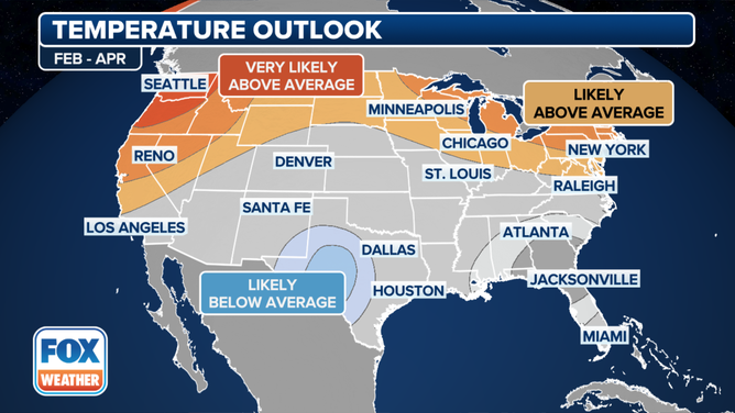
The temperature outlook for February, March and April from the Climate Prediction Center as of January 18, 2024.
(FOX Weather)
According to the CPC, the February through April 2024 temperature outlook shows above-average temperatures are likely across the Pacific Northwest, northern and central California, parts of the Great Basin, the northern Rockies, the northern Plains, the Great Lakes region, the Northeast and New England.
The highest confidence for above-average temperatures exists for the Pacific Northwest and Alaska, according to the CPC.
The below-average temperature confidence is slightly elevated across southeastern New Mexico and western and central Texas.
Near-normal temperatures through April are favored for much of the Southeast.
HERE'S WHAT AN EL NINO CLIMATE PATTERN IS
Precipitation outlook
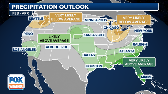
The precipitation outlook for February, March and April from the Climate Prediction Center as of January 18, 2024.
(FOX Weather)
The February through April precipitation outlook shows elevated probabilities for above-normal precipitation for southern California, the desert Southwest, the central and southern Plains, the Southeast, and most of the East Coast, including the Interstate 95 corridor.
The Southeast is the most likely area to have above-normal precipitation through April, according to the CPC outlook.
Above-normal precipitation is also possible for parts of southern Alaska and the North Slope of Alaska.
Below-normal precipitation is favored for the Pacific Northwest, as well as from the Great Lakes to the Ohio Valley.
STRONG EL NINO WINTER: WHAT KIND OF WEATHER YOU CAN EXPECT
El Niño impacts in the U.S.
![Winter temperature anomalies]() Image 1 of 2
Image 1 of 2Winter temperature anomalies during weak, moderate and strong events ( )
![Winter precipitation anomalies]() Image 2 of 2
Image 2 of 2Winter precipitation anomalies during weak, moderate and strong events ( )


El Niño events typically have great impacts on weather around the country during meteorological winter, which runs from December through February.
Depending on the event’s strength, the southern tier of the country usually sees cooler-than-average temperatures, while the northern half can experience occasional breaks from the brutally long winters.
The impacts can be significant along the West Coast and lead to enhanced precipitation.
All El Niño events are not similar, and NOAA says despite more than four decades of research, it continuously monitors important regions to better understand impacts.
Major El Niño events in 1982-83 and 1997-98 produced more than 150 percent of average precipitation in the Golden State, but the record-breaking El Niño of 2015-16 led to less rainfall than during even non-El Niño events.