El Nino holds strong but days numbered as odds increase for La Nina return
Forecasters said the atmosphere across the Pacific is in a robust El Niño pattern, but indications are that some areas of the tropical Pacific are already cooling.
The meaning of El Nino and La Nina
The status of whether the world is being impacted by an El Nino or a La Nina is determined by water temperatures in the central and eastern Pacific. (NOAA)
COLLEGE PARK, Md. – El Niño is still here, but its strength is likely peaking and a rapid decline to neutral status is in the cards soon, NOAA said in its monthly update on the El Niño-Southern Oscillation status.
According to data compiled by NOAA, the temperatures in the central Pacific Ocean, where El Niño is measured, remained at 1.9 degrees Celsius (3.4 degrees Fahrenheit) above average. A status of at least 2 degrees Celsius above average would have pushed the event’s standing into "super El Niño" status, the first since 2015-16. But it appears this event will come up just shy.
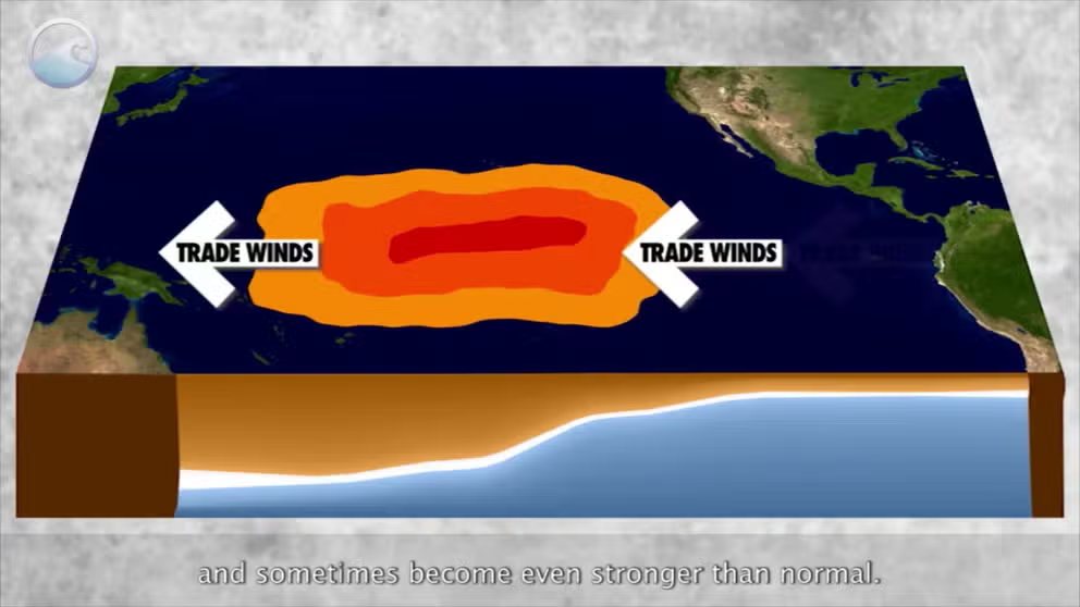
WHAT ARE THE EL NIÑO AND LA NIÑA PATTERNS?
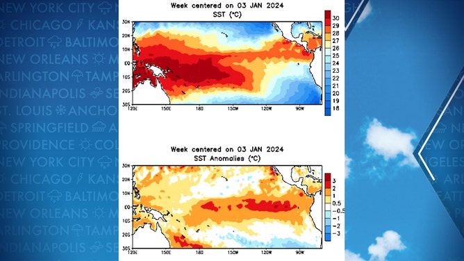
Weekly averaged sea-surface temperatures (top) and anomalies (bottom) for the past 12 weeks.
(NOAA)
Forecasters said the atmosphere across the Pacific is in a robust El Niño pattern, but indications are that some areas of the tropical Pacific are already cooling. The majority of the latest forecasts show the tropical Pacific Ocean temperature anomalies will cool back under the El Niño threshold by April. Some models even indicate it could happen as early as March, but forecasters say, based on previous experience, they believe it'll wait until April.
But the cooling may not stop at neutral status. The latest forecasts now indicate increasing odds that the Pacific will return to La Niña status by late summer, with over a 50% chance of La Niña conditions by July and a 60% chance La Niña conditions will be present by August.
The U.S. just came out of a rare "triple dip" La Niña in the winters of 2020-21 through 2022-23 before boomeranging into the strong El Niño this winter.
The La Niña phase typically correlates to dry weather in the southern U.S. and cooler, wetter weather in the Pacific Northwest and parts of the North.
WHAT LA NINA COULD MEAN FOR SEVERE WEATHER OUTBREAKS, HURRICANE SEASON
In addition, La Niña patterns tend to affect the Atlantic hurricane season.
"If the water in the box east of the International Dateline and south of Hawaii is persistently significantly below 0.5 degrees Celsius, research has shown that more hurricanes develop," FOX Weather Hurricane Specialist Bryan Norcross said. "Cold water in the Pacific Ocean tends to create upper winds across the Atlantic that are more conducive to storm development."
In the meantime, robust El Niño-influenced weather patterns are expected to continue this winter, which, despite the current impending arctic air intrusion, would overall feature milder and drier winter conditions in the North and a wetter winter in the South.