First March storm could spawn severe weather outbreak in South, another round of snow, ice for Northeast
This storm system comes on the heels of another cross-country storm, which produced severe thunderstorms and tornadoes in the Plains on Sunday and brought snow to the Upper Midwest and Northeast from Monday into Tuesday.
Severe outbreak, heavy snow possible in US as March begins
On the warm side, severe thunderstorms may produce damaging winds and tornadoes in the South from Wednesday through Friday. On the winter side of the system, there is the potential for heavy snow in the Great Lakes and Northeast by midweek.
March is expected to come in like a lion as the FOX Forecast Center tracks a potent storm system that will impact millions across the eastern half of the U.S. later this week, posing serious threats of severe weather, heavy snow and ice.
This storm system comes on the heels of another cross-country storm, which produced severe thunderstorms and tornadoes in the Plains on Sunday and brought snow to the Upper Midwest and Northeast from Monday into Tuesday.
Multiday severe weather threat eyes South beginning Wednesday
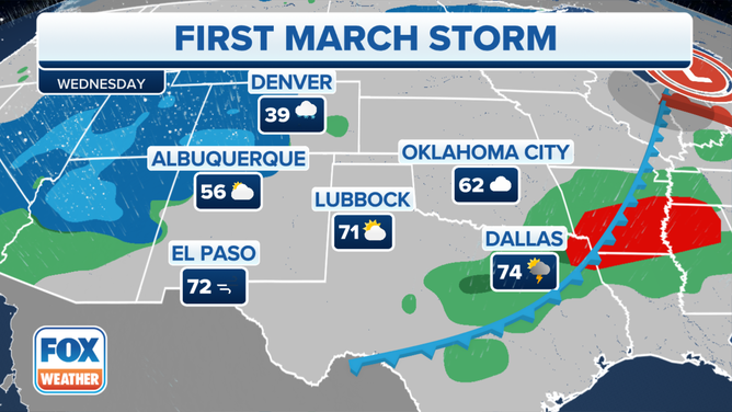
Wednesday
On the southern and warm side of this storm system, a multiday threat of severe thunderstorms will kick off Wednesday, highlighted by a potential severe weather outbreak brewing for Thursday.
Wednesday's threat of severe weather will extend from northeastern Texas to the lower Mississippi and Tennessee valleys. According to the FOX Forecast Center, large hail and damaging wind gusts are the main threats, but a couple of tornadoes are also possible.

(FOX Weather)
Heavy rain in the South will also lead to some concerns for flash flooding.
The heaviest rain is expected to fall from Arkansas through the Tennessee Valley and the Carolinas as the storm system continues to push to the east.
Between 3 and 5 inches of rain could soak portions of Tennessee, which will likely see the highest rainfall totals.

(FOX Weather)
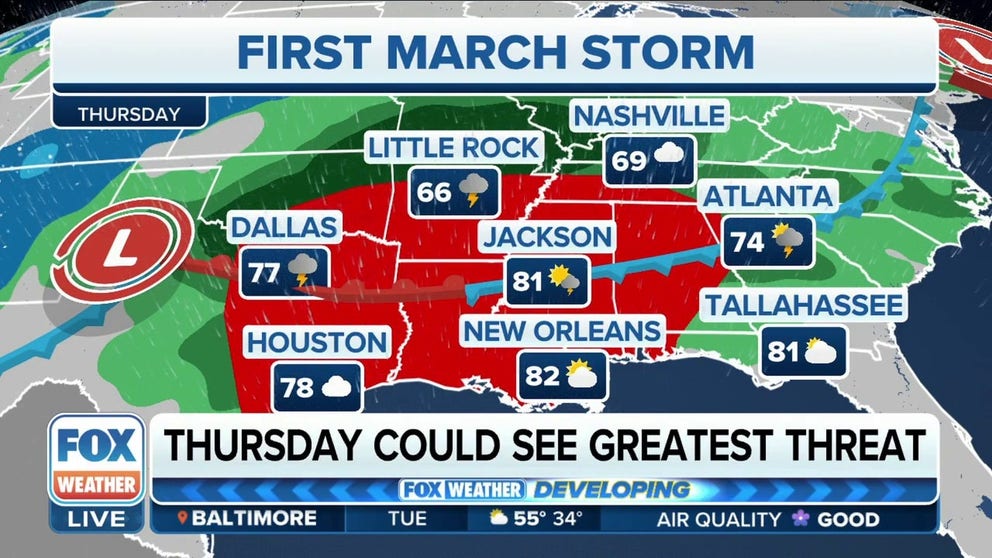
Thursday
The severe weather threat will ramp up on Thursday when a severe weather outbreak is possible. As of Tuesday, the threat extends from portions of North and East Texas, including the Dallas, Waco and Houston metros, into the lower Mississippi Valley and the Deep South.
The FOX Forecast Center believes that these severe thunderstorms could last through the overnight hours and continue into Friday.
The highest risk will be seen across North and East Texas through southeastern Oklahoma, central and southern Arkansas, central and northern Louisiana and central and northern Mississippi. Tornadoes, damaging wind gusts and large hail are all possible. Some of the tornadoes could be EF-2 or stronger.

(FOX Weather)
Heavy rain is also expected across the region, which could lead to areas of flash flooding.
Flash flooding is possible from Texas to the Ohio Valley, but the highest chances of seeing flooding will be in parts of Arkansas, including Little Rock, and western portions of Tennessee and Kentucky.

(FOX Weather)
Friday
The severe weather threat will advance into the Southeast by Friday.
The FOX Forecast Center believes the highest risk for severe weather will be found across Alabama, Georgia, Middle and East Tennessee, southeastern Kentucky and the Carolinas. Damaging wind gusts a couple of tornadoes are the main threats.

(FOX Weather)
Heavy snow possible from Mississippi Valley to Northeast
As a powerful low-pressure system forms, the storm will rapidly gear up on Thursday. As a result, snow is expected to develop where the coldest air will be found across parts of the Texas Panhandle and Kansas.
By Friday, the threat of snow will stretch from Missouri to the Northeast as the low-pressure system moves into a wide swath of cold air. The FOX Forecast Center said the overlapping of the moisture with cold air would likely support a band of heavy snow in some of those areas.
![A look at the forecast on March 1, 2023.]() Image 1 of 4
Image 1 of 4A look at the forecast on March 1, 2023. (FOX Weather)
![A look at the forecast on March 2, 2023.]() Image 2 of 4
Image 2 of 4A look at the forecast on March 2, 2023. (FOX Weather)
![A look at the forecast on March 3, 2023.]() Image 3 of 4
Image 3 of 4A look at the forecast on March 3, 2023. (FOX Weather)
![A look at the forecast on March 4, 2023.]() Image 4 of 4
Image 4 of 4A look at the forecast on March 4, 2023. (FOX Weather)


There will also be an area of a mix between snow and freezing rain and sleet across portions of upstate New York, Pennsylvania and West Virginia.
By Saturday, the storm will begin to pull away from the region, with lingering snow in New England.

(FOX Weather)
This winter storm could significantly impact travel, but those details will be ironed out in the coming days.
While it’s still too early for specific snow-total predictions, it’s becoming more likely that the snowfall amounts could significantly impact travel on the roads and for people hoping to catch flights.
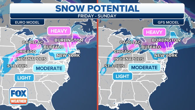
A computer model comparison for potential snow this week.
(FOX Weather)
Be sure to download the free FOX Weather app and enable notifications to be informed when there are changes to the forecast.