Hurricane Erin’s impacts to spread up East Coast as tropical storm alerts expand in North Carolina, Virginia
Hurricane Erin is not expected to make landfall in the United States, but forecasters are becoming increasingly concerned that outer bands from the growing hurricane could lash portions of the North Carolina and Virginia coasts with tropical-storm-force winds and heavy rain as the storm moves by.

Hurricane Erin maintaining strength off the Southeast
Coastal flooding is expected along the Carolinas and mid-Atlantic as a significant swell helps to pile up water along beaches.
HATTERAS, N.C. – A dangerous and potentially life-threatening situation is unfolding across portions of the East Coast as Tropical Storm alerts are in effect for parts of coastal Virginia and North Carolina’s Outer Banks as Hurricane Erin approaches the U.S.
Hurricane Erin is not expected to make landfall in the United States, but forecasters are becoming increasingly concerned that outer bands from the growing hurricane could lash portions of the North Carolina and Virginia coasts with tropical-storm-force winds and heavy rain as the storm moves by.
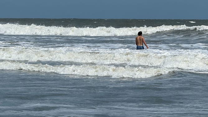
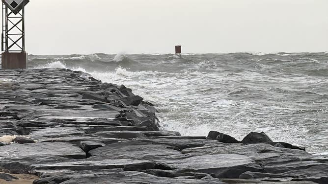
Massive waves generated by Hurricane Erin are also expected to pound the coast and rip currents could turn deadly for anyone daring to enter the water.
![Storm preps in Ocean City, Maryland]() Image 1 of 24
Image 1 of 24Heavy surf pounds the shores of Ocean City, Maryland ahead of Hurricane Erin's passby later this week. (Brandy Campbell)
![Surf along the beaches near Isle of Palms, South Carolina on Aug. 19, 2025 ahead of Hurricane Erin's major coastal impacts.]() Image 2 of 24
Image 2 of 24Surf along the beaches near Isle of Palms, South Carolina on Aug. 19, 2025 ahead of Hurricane Erin's major coastal impacts. (Robert Ray)
![Abandoned homes on Rodanthe Beach on Hatteras Islands, North Carolina ahead of Hurricane Erin's impacts.]() Image 3 of 24
Image 3 of 24Abandoned homes on Rodanthe Beach on Hatteras Islands, North Carolina ahead of Hurricane Erin's impacts. (Mike Seidel)
![Storm preps in Ocean City, Maryland]() Image 4 of 24
Image 4 of 24Heavy surf pounds the shores of Ocean City, Maryland ahead of Hurricane Erin's passby later this week. (Brandy Campbell)
![Surf along the beaches near Isle of Palms, South Carolina on Aug. 19, 2025 ahead of Hurricane Erin's major coastal impacts.]() Image 5 of 24
Image 5 of 24Surf along the beaches near Isle of Palms, South Carolina on Aug. 19, 2025 ahead of Hurricane Erin's major coastal impacts. (Robert Ray)
![Abandoned homes on Rodanthe Beach on Hatteras Islands, North Carolina ahead of Hurricane Erin's impacts.]() Image 6 of 24
Image 6 of 24Abandoned homes on Rodanthe Beach on Hatteras Islands, North Carolina ahead of Hurricane Erin's impacts. (Mike Seidel)
![Abandoned homes on Rodanthe Beach on Hatteras Islands, North Carolina ahead of Hurricane Erin's impacts.]() Image 7 of 24
Image 7 of 24Abandoned homes on Rodanthe Beach on Hatteras Islands, North Carolina ahead of Hurricane Erin's impacts. (Mike Seidel)
![This image provided by the North Carolina Department of Transportation shows a line of vehicles waiting to evacuate Ocracoke Island ahead of life-threatening impacts from Hurricane Erin.]() Image 8 of 24
Image 8 of 24This image provided by the North Carolina Department of Transportation shows a line of vehicles waiting to evacuate Ocracoke Island ahead of life-threatening impacts from Hurricane Erin. (North Carolina Department of Transportation)
![This image provided by the North Carolina Department of Transportation shows a line of vehicles waiting to evacuate Ocracoke Island ahead of life-threatening impacts from Hurricane Erin.]() Image 9 of 24
Image 9 of 24This image provided by the North Carolina Department of Transportation shows a line of vehicles waiting to evacuate Ocracoke Island ahead of life-threatening impacts from Hurricane Erin. (North Carolina Department of Transportation)
![A surfer rides a wave at La Pared beach as Category 5 Hurricane Erin approaches in Luquillo, Puerto Rico on August 16, 2025. Hurricane Erin rapidly strengthened offshore to a "catastrophic" Category 5 storm on August 16, as rain lashed Caribbean islands and weather officials warned of possible flash floods and landslides. The first hurricane of what is expected to be a particularly intense Atlantic season, Erin is expected to drench Caribbean islands with rain and strong winds but not make landfall.]() Image 10 of 24
Image 10 of 24A surfer rides a wave at La Pared beach as Category 5 Hurricane Erin approaches in Luquillo, Puerto Rico on August 16, 2025. Hurricane Erin rapidly strengthened offshore to a "catastrophic" Category 5 storm on August 16, as rain lashed Caribbean islands and weather officials warned of possible flash floods and landslides. The first hurricane of what is expected to be a particularly intense Atlantic season, Erin is expected to drench Caribbean islands with rain and strong winds but not make landfall. (RICARDO ARDUENGO/AFP)
![A surfer rides a wave at La Pared beach as Category 5 Hurricane Erin approaches in Luquillo, Puerto Rico on August 16, 2025. Hurricane Erin rapidly strengthened offshore to a "catastrophic" Category 5 storm on August 16, as rain lashed Caribbean islands and weather officials warned of possible flash floods and landslides.]() Image 11 of 24
Image 11 of 24A surfer rides a wave at La Pared beach as Category 5 Hurricane Erin approaches in Luquillo, Puerto Rico on August 16, 2025. Hurricane Erin rapidly strengthened offshore to a "catastrophic" Category 5 storm on August 16, as rain lashed Caribbean islands and weather officials warned of possible flash floods and landslides. (RICARDO ARDUENGO/AFP)
![This photo shows power lines that were brought down as a result of Hurricane Erin's winds in Puerto Rico on Aug. 17, 2025.]() Image 12 of 24
Image 12 of 24This photo shows power lines that were brought down as a result of Hurricane Erin's winds in Puerto Rico on Aug. 17, 2025. (@lumaenergypr/X)
![This image shows trees that were brought down as a result of Hurricane Erin's winds in Puerto Rico on Aug. 17, 2025.]() Image 13 of 24
Image 13 of 24This image shows trees that were brought down as a result of Hurricane Erin's winds in Puerto Rico on Aug. 17, 2025. (@lumaenergypr/X)
![Heavy waves are seen at La Pared beach as Category 5 Hurricane Erin approaches in Luquillo, Puerto Rico on August 16, 2025. Hurricane Erin rapidly strengthened offshore to a "catastrophic" Category 5 storm on August 16, as rain lashed Caribbean islands and weather officials warned of possible flash floods and landslides. The first hurricane of what is expected to be a particularly intense Atlantic season, Erin is expected to drench Caribbean islands with rain and strong winds but not make landfall. (Photo by Ricardo ARDUENGO / AFP) (Photo by RICARDO ARDUENGO/AFP via Getty Images)]() Image 14 of 24
Image 14 of 24Heavy waves are seen at La Pared beach as Category 5 Hurricane Erin approaches in Luquillo, Puerto Rico on August 16, 2025. Hurricane Erin rapidly strengthened offshore to a "catastrophic" Category 5 storm on August 16, as rain lashed Caribbean islands and weather officials warned of possible flash floods and landslides. The first hurricane of what is expected to be a particularly intense Atlantic season, Erin is expected to drench Caribbean islands with rain and strong winds but not make landfall. (Photo by Ricardo ARDUENGO / AFP) (Photo by RICARDO ARDUENGO/AFP via Getty Images) ( )
![Waves hit a structure as Category 5 Hurricane Erin approaches in San Juan, Puerto Rico, on August 16, 2025. Hurricane Erin on Saturday strengthened to a "catastrophic" Category 5 storm as it barrelled towards the Caribbean, with weather officials warning of possible flash floods and landslides. (Photo by Ricardo ARDUENGO / AFP) (Photo by RICARDO ARDUENGO/AFP via Getty Images)]() Image 15 of 24
Image 15 of 24Waves hit a structure as Category 5 Hurricane Erin approaches in San Juan, Puerto Rico, on August 16, 2025. Hurricane Erin on Saturday strengthened to a "catastrophic" Category 5 storm as it barrelled towards the Caribbean, with weather officials warning of possible flash floods and landslides. (Photo by Ricardo ARDUENGO / AFP) (Photo by RICARDO ARDUENGO/AFP via Getty Images) ( )
![A ripped red flag warning of rip current waves as Category 5 Hurricane Erin approaches in San Juan, Puerto Rico, on August 16, 2025. Hurricane Erin on Saturday strengthened to a "catastrophic" Category 5 storm as it barrelled towards the Caribbean, with weather officials warning of possible flash floods and landslides. (Photo by Ricardo ARDUENGO / AFP) (Photo by RICARDO ARDUENGO/AFP via Getty Images)]() Image 16 of 24
Image 16 of 24A ripped red flag warning of rip current waves as Category 5 Hurricane Erin approaches in San Juan, Puerto Rico, on August 16, 2025. Hurricane Erin on Saturday strengthened to a "catastrophic" Category 5 storm as it barrelled towards the Caribbean, with weather officials warning of possible flash floods and landslides. (Photo by Ricardo ARDUENGO / AFP) (Photo by RICARDO ARDUENGO/AFP via Getty Images) ( )
![Surf along the beaches near Isle of Palms, South Carolina on Aug. 19, 2025 ahead of Hurricane Erin's major coastal impacts.]() Image 17 of 24
Image 17 of 24Surf along the beaches near Isle of Palms, South Carolina on Aug. 19, 2025 ahead of Hurricane Erin's major coastal impacts. (Robert Ray)
![This image shared by FOX Weather Storm Specialist Mike Seidel shows Buxton, North Carolina, from the air.]() Image 18 of 24
Image 18 of 24This image shared by FOX Weather Storm Specialist Mike Seidel shows Buxton, North Carolina, from the air. (Mike Seidel)
![Surf along the beaches near Isle of Palms, South Carolina on Aug. 19, 2025 ahead of Hurricane Erin's major coastal impacts.]() Image 19 of 24
Image 19 of 24Surf along the beaches near Isle of Palms, South Carolina on Aug. 19, 2025 ahead of Hurricane Erin's major coastal impacts. (Robert Ray)
![Surf along the beaches near Isle of Palms, South Carolina on Aug. 19, 2025 ahead of Hurricane Erin's major coastal impacts.]() Image 20 of 24
Image 20 of 24Surf along the beaches near Isle of Palms, South Carolina on Aug. 19, 2025 ahead of Hurricane Erin's major coastal impacts. (Robert Ray)
![Surf along the beaches near Isle of Palms, South Carolina on Aug. 19, 2025 ahead of Hurricane Erin's major coastal impacts.]() Image 21 of 24
Image 21 of 24Surf along the beaches near Isle of Palms, South Carolina on Aug. 19, 2025 ahead of Hurricane Erin's major coastal impacts. (Robert Ray)
![Surf along the beaches near Isle of Palms, South Carolina on Aug. 19, 2025 ahead of Hurricane Erin's major coastal impacts.]() Image 22 of 24
Image 22 of 24Surf along the beaches near Isle of Palms, South Carolina on Aug. 19, 2025 ahead of Hurricane Erin's major coastal impacts. (Robert Ray)
![Storm preps in Ocean City, Maryland]() Image 23 of 24
Image 23 of 24Heavy surf pounds the shores of Ocean City, Maryland ahead of Hurricane Erin's passby later this week. (Brandy Campbell)
![Storm preps in Ocean City, Maryland]() Image 24 of 24
Image 24 of 24Heavy surf pounds the shores of Ocean City, Maryland ahead of Hurricane Erin's passby later this week. (Brandy Campbell)


The National Hurricane Center (NHC) issued a Tropical Storm Warning from Beaufort Inlet to Duck, North Carolina, and a Tropical Storm Watch is in effect from Cape Charles Light in Virginia to Chincoteague.
A Storm Surge Warning was issued for the North Carolina Outer Banks from Cape Lookout to Duck.
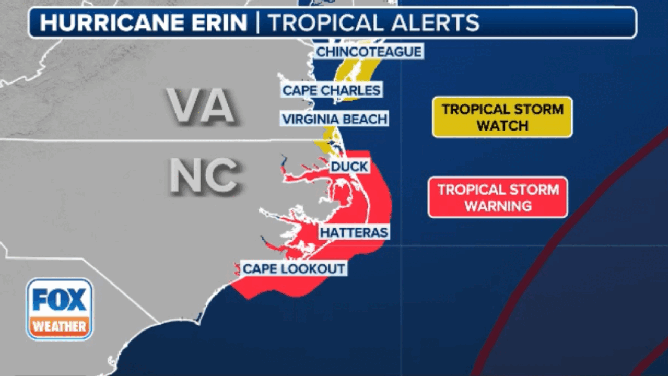
This animated graphic shows the tropical and storm surge alerts in effect due to Hurricane Erin.
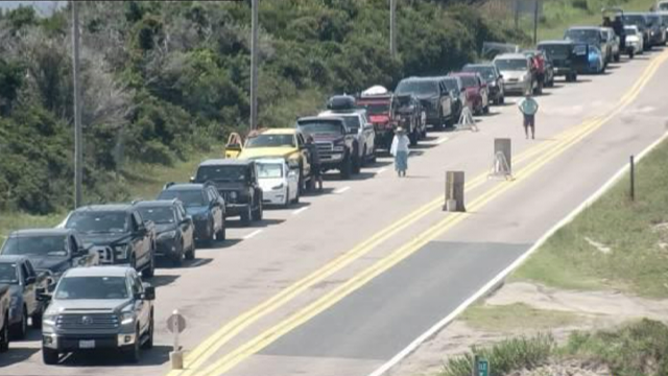
Because of the danger, officials in some North Carolina communities told residents and visitors to evacuate and declared local states of emergency ahead of the possible life-threatening impacts.
"The State Emergency Response Team is poised and ready to respond to any needs from our local communities this week," North Carolina Emergency Management Director Will Ray said in a statement. "As forecasted impacts become clearer, we will plan for the pre-positioning of any necessary resources for rapid deployment along our coast. In the meantime, all visitors and residents along the coast should follow the instructions of local emergency management officials to keep you and your family safe," he added.

North Carolina beaches close as homes threatened by growing waves ahead of Hurricane Erin
Several beaches along North Carolina's Outer Banks have already closed and evacuations are underway due to the expected storm surge from Hurricane Erin. FOX Weather Storm Specialist Mike Seidel has the latest from Rodanthe.
Officials said that with the forecast showing the potential for tropical-storm-force winds, dangerous surf with waves of 15-20 feet at local beaches, flooding of roads and neighborhoods and rip currents along the Outer Banks, officials in some counties announced evacuation orders over the weekend.
Hyde County declared a local state of emergency for Ocracoke Island, and a mandatory evacuation order was issued for visitors on Sunday night and for residents on Tuesday morning.
DOWNLOAD THE FREE FOX WEATHER APP

Minor flooding along Highway 12 on Ocracoke Island after high tide on Tuesday, Aug. 19, 2025.
(NC DOT / FOX Weather)
Dare County also declared a state of emergency and ordered the evacuation of Hatteras Island, which includes the communities of Rodanthe, Waves, Salvo, Avon, Buxton, Frisco and Hatteras. Visitors began to evacuate on Monday, and residents started their evacuation on Tuesday morning.
A spokesperson for Wrightsville Beach, North Carolina, told FOX Weather their rescue crews conducted nearly 60 water rescues on Monday and another 20 on Tuesday due to strong rip currents. The town has now told all beachgoers to stay out of the water through Friday as Erin gets even closer.
"These swells are producing powerful rip currents that can create extremely hazardous swimming conditions," said Sam Proffitt, director of Wrightsville Beach Ocean Rescue. "The safety of our beachgoers is always our top priority, and we urge everyone to follow this advisory."

Stay with FOX Weather for continuing coverage of Hurricane Erin this week.
(FOX Weather)
To the north in New York and New Jersey, officials have prohibited swimming and other recreational water activities due to massive waves and life-threatening rip currents.
All New York City public beaches are closed for swimming on Wednesday and Thursday, Mayor Eric Adams' office announced Tuesday.
In New Jersey, swimming, mobile sport fishing vehicle access and other programs have been suspended at Island Beach State Park through at least Thursday due to the hazardous water conditions.

Hurricane Erin expected to create life-threatening coastal conditions for Jersey Shore, East Coast
Joe Bongiovanni, Beach Safety Supervisor for Asbury Park, New Jersey joined FOX Weather First to discuss the the expected impacts that Hurricane Erin will have on New Jersey beaches this week.
"The Wildwood Beach Patrol advises everyone to stay out of the water and to heed all warnings," the police department said. "This restriction includes after-hours, when lifeguards are off-duty."
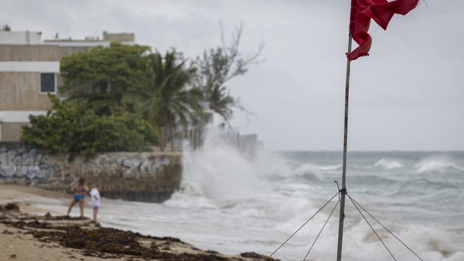
Officials also prohibited beachgoers from entering the water at Maryland's Assateague State Park due to dangerous ocean surf and rip currents.

Red flags denote warnings to stay out of the water at Maryland's Assateague State Park on Aug. 19, 2025 as Hurricane Erin approaches offshore, making for dangerous ocean conditions.
(Maryland DNR / FOX Weather)
The Margate City Beach Patrol has also prohibited swimming and bathing until further notice.
"We do not recommend surfing and kayaking at this time," officials said. "Any surfers and kayakers who do venture into the water will be performing these activities at their own risk."
The Margate City Beach Patrol said that wasn’t a decision that they came to lightly, but their "priority is the safety of our beachgoers and lifeguards."
HURRICANE ERIN THREATENS NORTH CAROLINA'S OUTER BANKS WITH ‘EXTREME BEACH AND COASTAL DAMAGE’
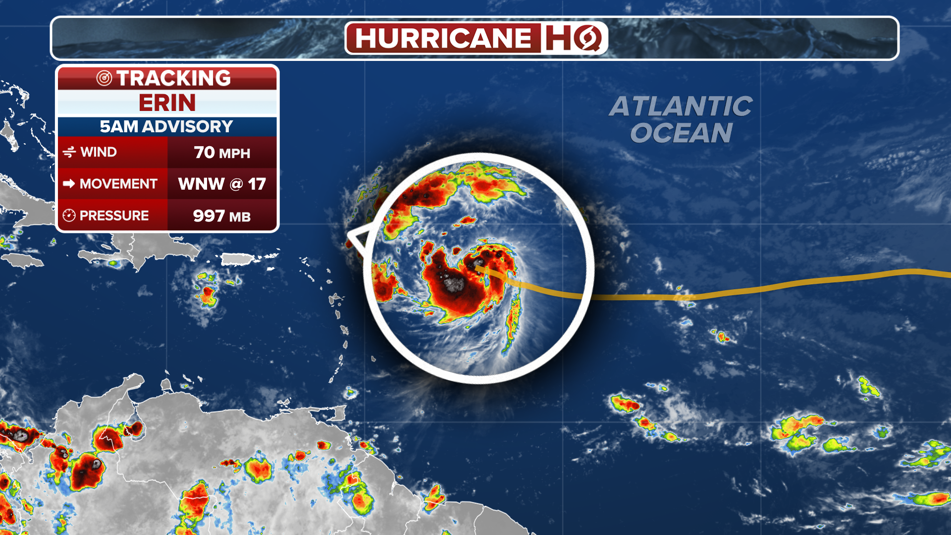
Where is Hurricane Erin?
(FOX Weather)
Hurricane Erin has maximum sustained winds of 100 mph with some higher gusts, and the National Hurricane Center (NHC) said that some fluctuations in strength are possible over the next few days.
Hurricane Erin rapidly intensified last week, going from a Category 1 hurricane to a Category 5 hurricane with winds of 160 mph in a matter of hours.
At the time, it was a tiny, compact storm, but that’s no longer the case.
"The more important part of the forecast is that model guidance has continued to show Erin growing in size, and the wind radii have been made larger in the new NHC forecast," the NHC said. "This new forecast now brings tropical-storm-force winds very close to the Mid-Atlantic and southern New England coast later this week."
Currently, hurricane-force winds extend outward up to 80 miles from Erin's center, and tropical-storm-force winds extend outward up to 205 miles.

(FOX Weather)