Hurricane Erin's storm surge on North Carolina’s Outer Banks could be 'significant threat to life, property'
Hurricane Erin won't make landfall in the U.S., but this monster storm will create life-threatening coastal conditions for the Outer Banks this week. The National Weather Service is warning of "extreme beach and coastal damage ... resulting in a significant threat to life and property." Tropical Storm and Storm Surge conditions are expected beginning Wednesday.

North Carolina beaches close as homes threatened by growing waves ahead of Hurricane Erin
Several beaches along North Carolina's Outer Banks have already closed and evacuations are underway due to the expected storm surge from Hurricane Erin. FOX Weather Storm Specialist Mike Seidel has the latest from Rodanthe.
KITTY HAWK, N.C. – Forecasters in North Carolina are becoming increasingly concerned about life-threatening impacts from Hurricane Erin along the Outer Banks, including strong winds and massive waves that could cause "extreme" damage to beach and coastal areas, as well as a storm surge that has the potential to be a "significant threat to life and property."
While the U.S. will be spared a landfall from monster Hurricane Erin, which was sitting at Category 2 strength as of Tuesday morning, the impacts will be felt up and down the East Coast throughout the week with life-threatening coastal conditions, rip currents and big waves.

Watch: Crews build up sand dunes on Hatteras Island ahead of Hurricane Erin's impacts
A video shared by FOX Weather Storm Specialist Mike Seidel shows crews working to build up the sand dunes on Highway 12 on Hatteras Island, North Carolina, ahead of impacts from Hurricane Erin.
The Outer Banks will face the brunt of these conditions starting on Tuesday.
According to the National Hurricane Center, tropical storm conditions and coastal flooding are possible in the North Carolina Outer Banks beginning late Wednesday, where Tropical Storm and Storm Surge Warnings are in effect.
"The storm surge will be accompanied by large waves, leading to significant beach erosion and overwash, making some roads impassible," the National Hurricane Center said.
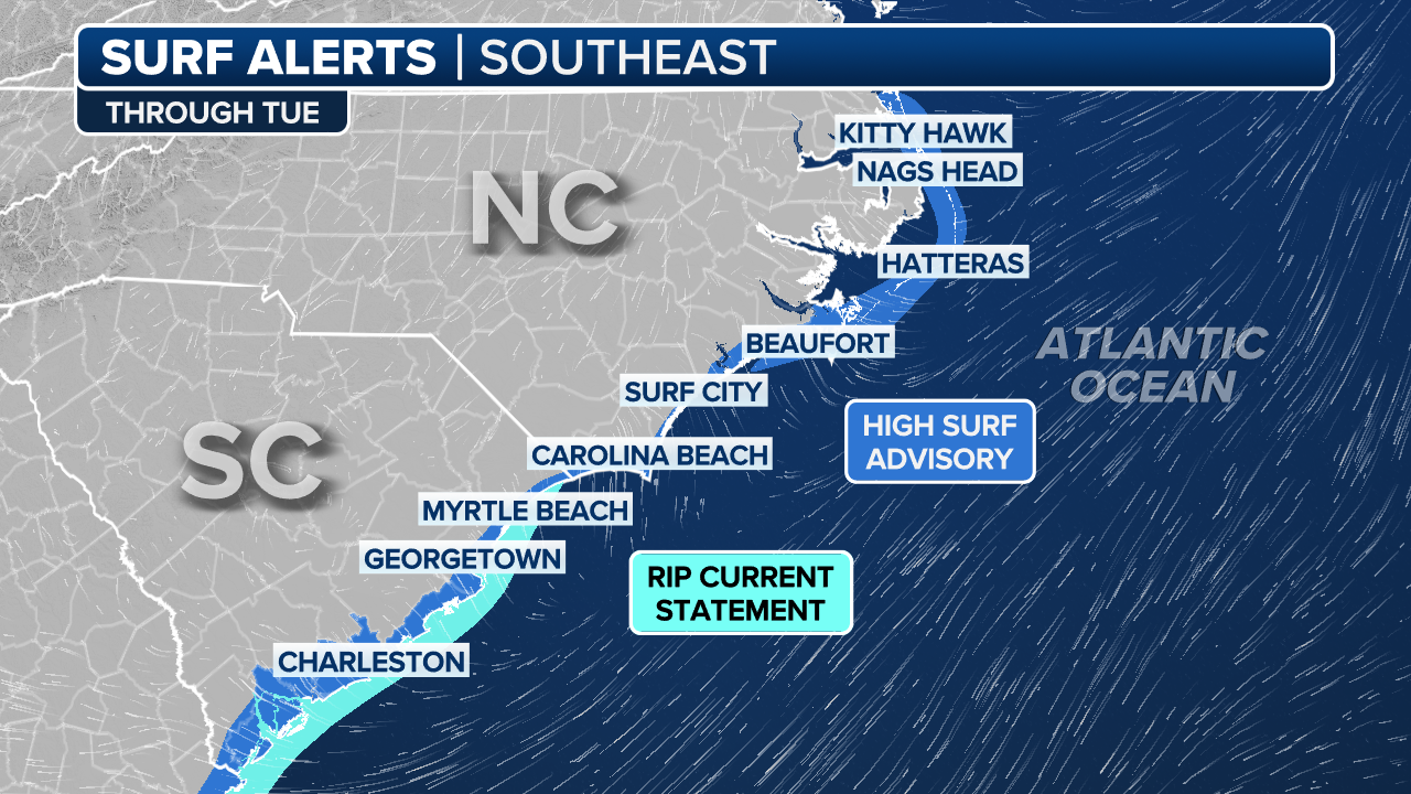
The National Weather Service in Newport-Morehead City, North Carolina, issued an ominous-sounding High Surf Advisory and Coastal Flood Watch with its beach hazard statement.
![Abandoned homes on Rodanthe Beach on Hatteras Islands, North Carolina ahead of Hurricane Erin's impacts.]() Image 1 of 10
Image 1 of 10Abandoned homes on Rodanthe Beach on Hatteras Islands, North Carolina ahead of Hurricane Erin's impacts. (Mike Seidel)
![Abandoned homes on Rodanthe Beach on Hatteras Islands, North Carolina ahead of Hurricane Erin's impacts.]() Image 2 of 10
Image 2 of 10Abandoned homes on Rodanthe Beach on Hatteras Islands, North Carolina ahead of Hurricane Erin's impacts. (Mike Seidel)
![Abandoned homes on Rodanthe Beach on Hatteras Islands, North Carolina ahead of Hurricane Erin's impacts.]() Image 3 of 10
Image 3 of 10Abandoned homes on Rodanthe Beach on Hatteras Islands, North Carolina ahead of Hurricane Erin's impacts. (Mike Seidel)
![Minor flooding along Highway 12 on Ocracoke Island after high tide on Tuesday, Aug. 19, 2025.]() Image 4 of 10
Image 4 of 10Minor flooding along Highway 12 on Ocracoke Island after high tide on Tuesday, Aug. 19, 2025. (NC DOT)
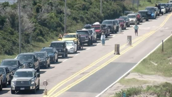
![This image provided by the North Carolina Department of Transportation shows a line of vehicles waiting to evacuate Ocracoke Island ahead of life-threatening impacts from Hurricane Erin.]() Image 5 of 10
Image 5 of 10This image provided by the North Carolina Department of Transportation shows a line of vehicles waiting to evacuate Ocracoke Island ahead of life-threatening impacts from Hurricane Erin. (North Carolina Department of Transportation)
![This image provided by the North Carolina Department of Transportation shows a line of vehicles waiting to evacuate Ocracoke Island ahead of life-threatening impacts from Hurricane Erin.]() Image 6 of 10
Image 6 of 10This image provided by the North Carolina Department of Transportation shows a line of vehicles waiting to evacuate Ocracoke Island ahead of life-threatening impacts from Hurricane Erin. (North Carolina Department of Transportation)
![]() Image 7 of 10
Image 7 of 10( )
![Surf along the beaches near Isle of Palms, South Carolina on Aug. 19, 2025 ahead of Hurricane Erin's major coastal impacts.]() Image 8 of 10
Image 8 of 10Surf along the beaches near Isle of Palms, South Carolina on Aug. 19, 2025 ahead of Hurricane Erin's major coastal impacts. (Robert Ray)
![Surf along the beaches near Isle of Palms, South Carolina on Aug. 19, 2025 ahead of Hurricane Erin's major coastal impacts.]() Image 9 of 10
Image 9 of 10Surf along the beaches near Isle of Palms, South Carolina on Aug. 19, 2025 ahead of Hurricane Erin's major coastal impacts. (Robert Ray)
![Surf along the beaches near Isle of Palms, South Carolina on Aug. 19, 2025 ahead of Hurricane Erin's major coastal impacts.]() Image 10 of 10
Image 10 of 10Surf along the beaches near Isle of Palms, South Carolina on Aug. 19, 2025 ahead of Hurricane Erin's major coastal impacts. (Robert Ray)


"Extreme beach and coastal damage is likely along the oceanside, resulting in a significant threat to life and property," the NWS Newport-Morehead City said. "Large dangerous waves will likely inundate and destroy protective dune structures."
These advisories cover Carteret County, the northern Outer Banks, Ocracoke Island and Hatteras Island. After local officials spoke with the NWS, evacuation orders were issued for the islands due to Hurricane Erin’s dangerous surf, wind and flooding threats. Dare County is also under a state of emergency.
(FOX Weather)
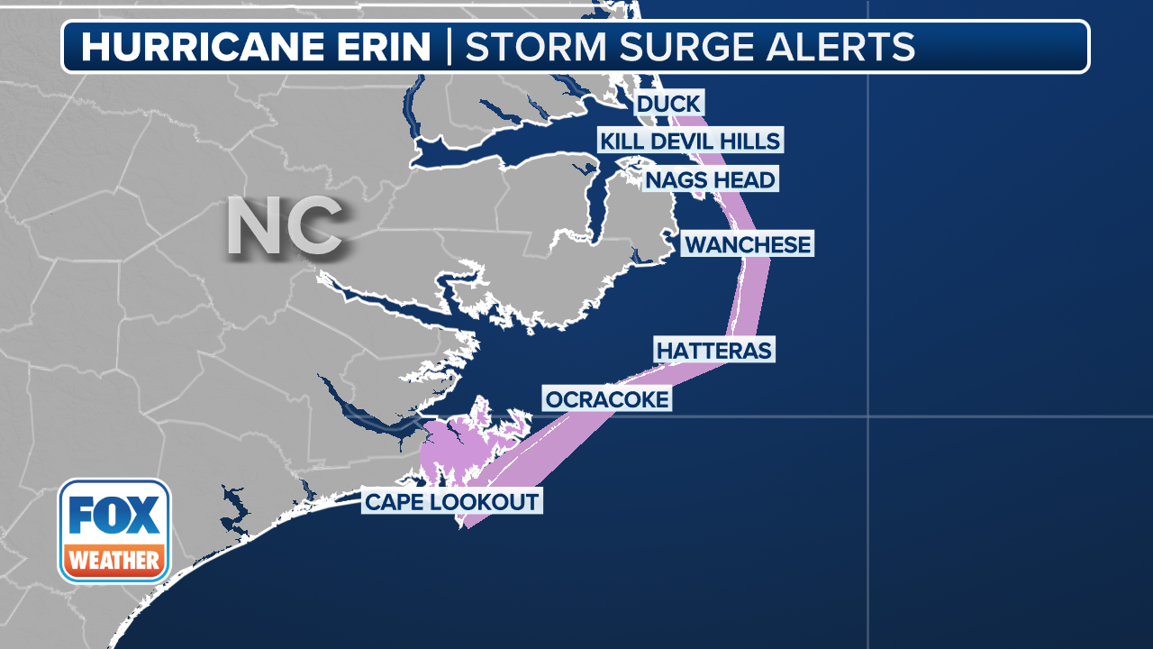
"Moderate to significant storm surge inundation of 2 to 4 feet above ground level is expected along the oceanside, resulting in a significant threat to life and property," the NWS said.
In addition, forecasters said "severe flooding will likely extend inland from the waterfront causing flooding of many homes and businesses with some structural damage possible."
With the current forecast, portions of Highway 12 on Hatteras Island are likely to be impassable for several days.
Erin targets areas hard hit by ongoing beach erosion
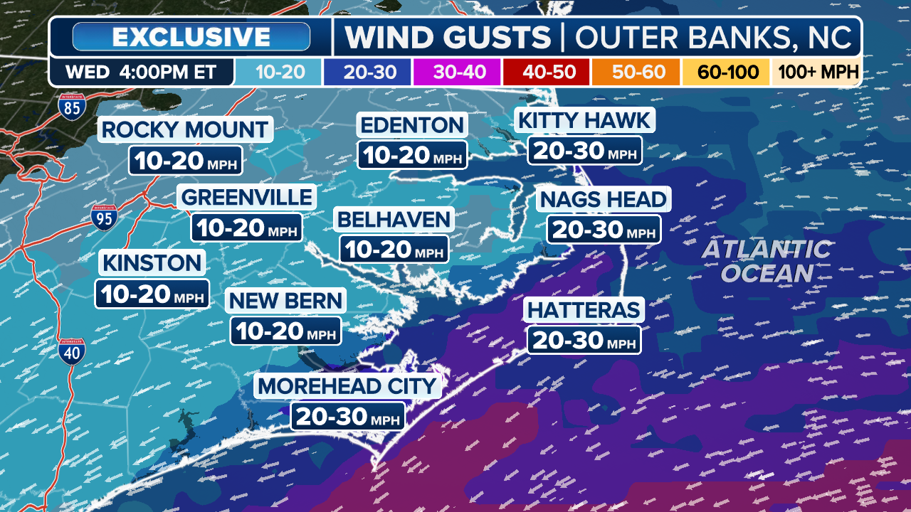
Erin is forecast to still be a Category 2 or 3 hurricane as it passes well offshore of the Outer Banks late Wednesday and into Thursday. The Outer Banks could see winds of up to 60 mph and waves up to 20 feet, including Nags Head, Kitty Hawk and Hatteras Island.

(FOX Weather)
It doesn't take much for these areas to flood, and with Erin's massive wind field and waves, coastal erosion is also likely.
A Storm Surge Watch has been issued from Cape Lookout to Duck, North Carolina.
(FOX Weather)
Hurricane Erin will only intensify the ongoing threat of erosion and rising sea levels in the Outer Banks, where oceanfront homes have been collapsing into the sea over the past several years, including four along the Cape Hatteras National Seashore last year.
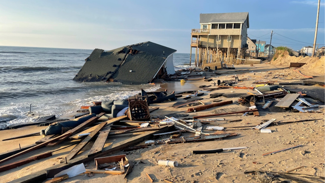
FILE PHOTO: This photo shows a home that collapsed into the Atlantic Ocean along the Cape Hatteras National Seashore in North Carolina on Tuesday, May 28, 2024.
(National Park Service)
FOURTH HOME COLLAPSES INTO SURF ALONG NORTH CAROLINA'S OUTER BANKS IN 2024
Large breaking waves between 15 and 20 feet are expected in the surf zone for the High Surf Advisory areas.
"This is expected to be a prolonged duration event beginning Tuesday, peaking Wednesday into Thursday then gradually improving late week, with water levels peaking during the high tides," the NWS said.
The advisory is in place through Friday night.
(FOX Weather)
Dangerous rip currents are also expected, and people are being told to avoid the water.
"Very dangerous swimming and surfing conditions expected, as well as the wave action resulting in significant beach erosion. Rip currents can sweep even the best swimmers away from shore into deeper water," the NWS said.

Wrightsville Beach officials warn of dangerous rip currents
As Hurricane Erin creates extremely dangerous beach conditions all up the East Coast, officials from Wrightsville Beach, North Carolina, are warning people to stay out of the ocean. Sam Proffitt, director for Wrightsville Beach Ocean Rescue, joined FOX Weather to talk about the dangers from rip currents and the 80 water rescues his agency has done just since Monday.