Hurricane Erin begins slamming East Coast with dangerous surf, rip currents
Erin is forecast to remain a dangerous hurricane as it pulls up alongside the U.S. this week, bringing damaging winds and waves up to 20 feet. Rip currents, coastal flooding, storm surge and erosion will remain threats from Erin through Friday up and down the East Coast.

North Carolina beaches close as homes threatened by growing waves ahead of Hurricane Erin
Several beaches along North Carolina's Outer Banks have already closed and evacuations are underway due to the expected storm surge from Hurricane Erin. FOX Weather Storm Specialist Mike Seidel has the latest from Rodanthe.
While the U.S. will be spared a landfall from monster Hurricane Erin, impacts are beginning up and down the East Coast as this massive storm brings life-threatening coastal conditions, rip currents and big waves.
Erin is a Category 2 hurricane forecast to stay offshore in the Atlantic, threading the needle between Bermuda and the U.S. coast. As Erin begins to pull up alongside the Bahamas and then Florida, this giant tropical system will bring coastal flooding and extremely dangerous conditions for boaters and people living in coastal communities from Florida to Atlantic Canada.
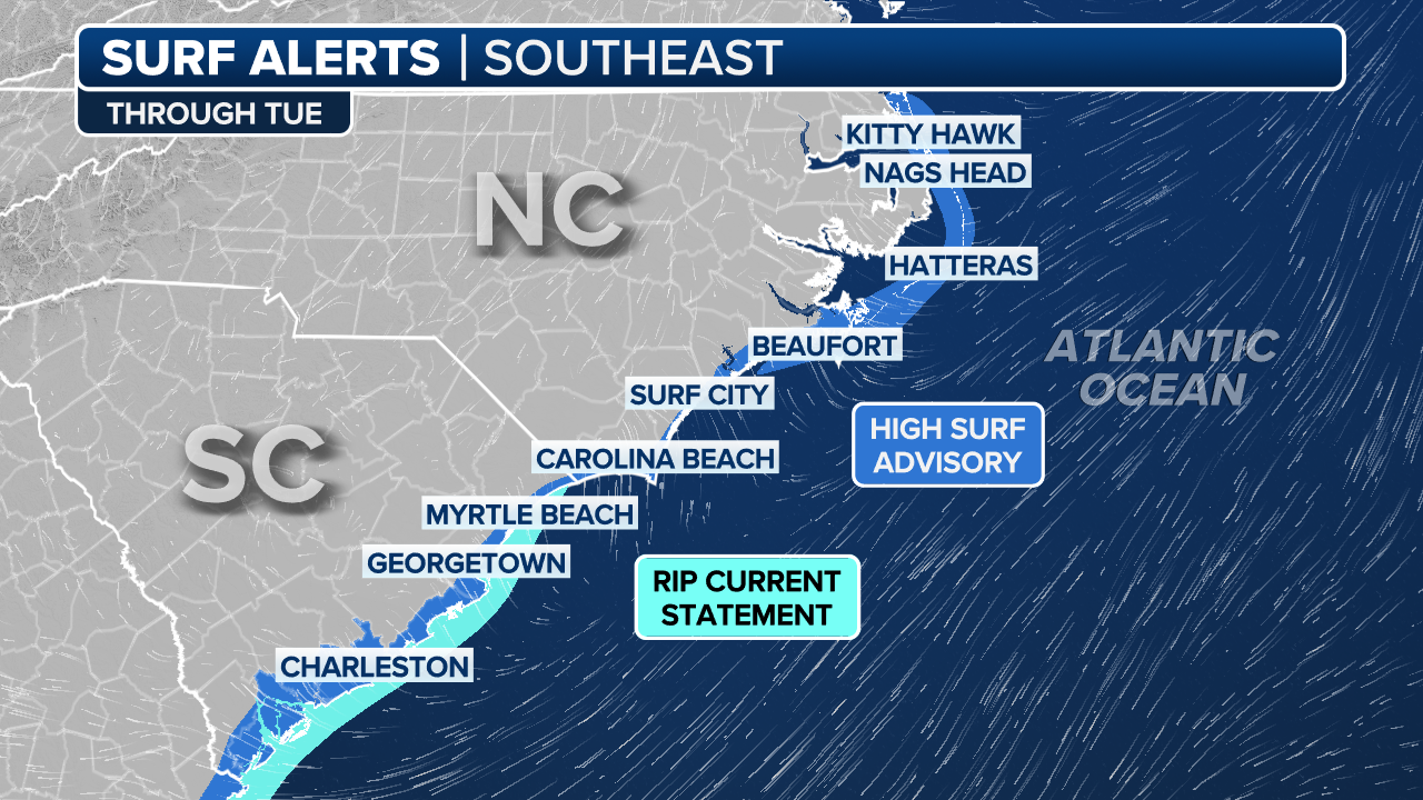
Storm Surge and Tropical Storm Warnings are in place for parts of North Carolina's Outer Banks from Cape Lookout to Duck.
(FOX Weather)
Hurricane Erin’s extremely large size will also bring dangerous winds and plenty of rain to the U.S. East Coast. According to the National Hurricane Center, hurricane-force winds extend outward up to 80 miles, while tropical-storm-force winds extend outward up to 230 miles.
When will the US feel Erin’s impacts?

(FOX Weather)
Flooding, rip currents, small craft and wave advisories are already in place for many areas from Florida to New England.
Things are already getting busy for the Southeast as rough sea conditions are beginning, according to FOX Weather Hurricane Specialist Bryan Norcross.
"Already, the rip current risk is high along most of the U.S. East Coast, and the effects from the storm have only barely begun – there has already been a series of rescues at the beach in North Carolina," Norcross said on Tuesday.
Nearly 60 people were rescued near Wrightsville Beach due to rip currents on Monday, officials told FOX Weather.
(FOX Weather)
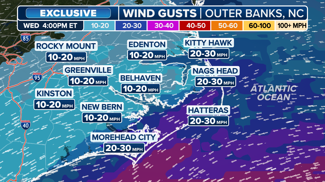
Peak wave heights and damaging winds in the Carolinas are forecast to occur from Wednesday night into Thursday morning. Tropical Storm and Storm Surge conditions are expected beginning Wednesday.
Some communities along the Outer Banks are already under evacuation with the impending threat of coastal flooding, winds and waves.
![Abandoned homes on Rodanthe Beach on Hatteras Islands, North Carolina ahead of Hurricane Erin's impacts.]() Image 1 of 4
Image 1 of 4Abandoned homes on Rodanthe Beach on Hatteras Islands, North Carolina ahead of Hurricane Erin's impacts. (Mike Seidel)
![Abandoned homes on Rodanthe Beach on Hatteras Islands, North Carolina ahead of Hurricane Erin's impacts.]() Image 2 of 4
Image 2 of 4Abandoned homes on Rodanthe Beach on Hatteras Islands, North Carolina ahead of Hurricane Erin's impacts. (Mike Seidel)
![Abandoned homes on Rodanthe Beach on Hatteras Islands, North Carolina ahead of Hurricane Erin's impacts.]() Image 3 of 4
Image 3 of 4Abandoned homes on Rodanthe Beach on Hatteras Islands, North Carolina ahead of Hurricane Erin's impacts. (Mike Seidel)
![Minor flooding along Highway 12 on Ocracoke Island after high tide on Tuesday, Aug. 12, 2025.]() Image 4 of 4
Image 4 of 4Minor flooding along Highway 12 on Ocracoke Island after high tide on Tuesday, Aug. 12, 2025. (NC DOT)


The Outer Banks could see winds of up to 60 mph and waves up to 20 feet, including Nags Head, Kitty Hawk and Hatteras Island. It doesn't take much for these areas to flood, and with Erin's wide wind field and waves, coastal erosion is also likely.
A High Surf Advisory is in place for the Outer Banks through Friday.
(FOX Weather)
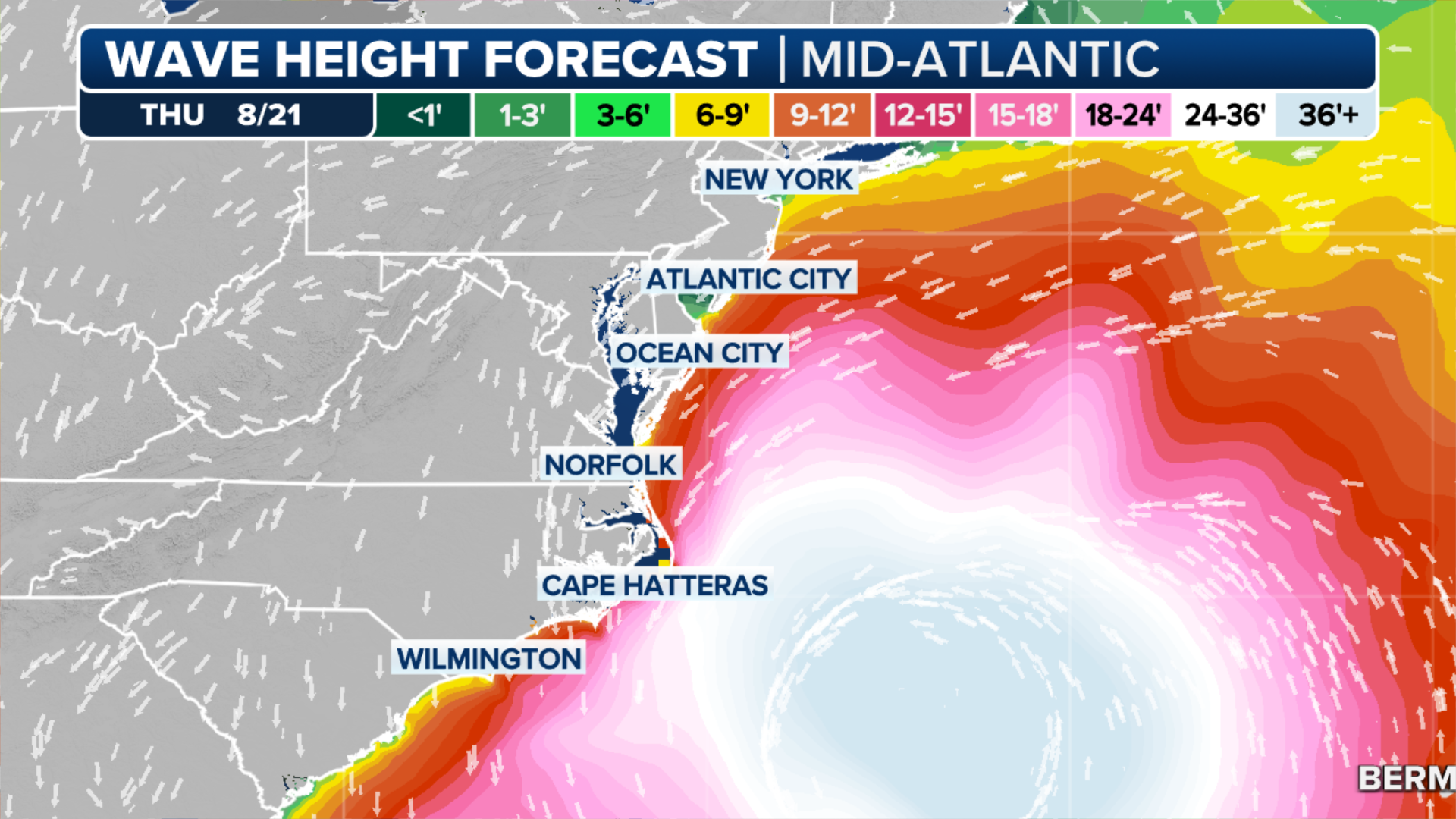
Then Erin’s energy will move north with impacts in the mid-Atlantic, Northeast and New England coasts.
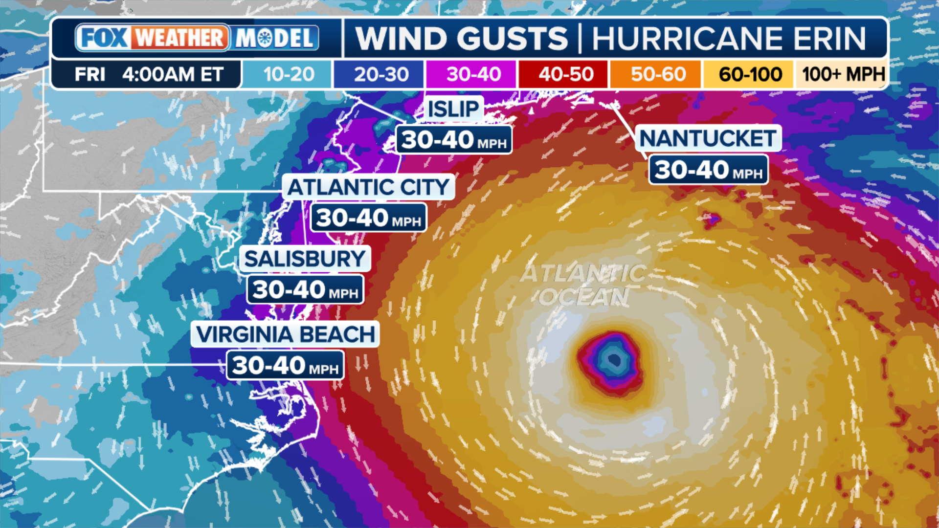
Large breaking waves, rip currents and damaging winds are possible for these areas through Friday. Waves are forecast to reach between 8 and 12 feet, with peak winds of around 40 mph possible from Virginia Beach, Virginia, to Nantucket, Massachusetts.
A Coastal Flood Advisory is in place for much of the Delaware and New Jersey coastlines through Tuesday night.
(FOX Weather)
"As the hurricane moves north, the focus of the energy will move north to the coastline from Cape Hatteras to New England, including the Tidewater of Virginia, the Delmarva, the Jersey Shore, Long Island, New York, and the New England coast," Norcross said.
(FOX Weather)
By Friday, Erin should be moving between Bermuda and Atlantic Canada, where coastal impacts are possible into the weekend.