Tropical waves brew behind Hurricane Erin as Main Development Region roars to life with 2 areas to watch
The first area has been under the eyes of the National Hurricane Center for a few days as it emerged off Africa's west coast. The second area is several hundred miles southeast of the Cabo Verde Islands off the coast of Africa and was designated as Invest 99L on Tuesday, which allows the NHC to run specialized computer forecast models on the system to obtain more information about its future track and intensity.
National Hurricane Center highlights two areas to watch looming behind Hurricane Erin
FOX Weather Meteorologist Steve Bender shares an update on the two areas to watch, as a tropical threat looms behind Hurricane Erin.
The National Hurricane Center (NHC) is monitoring two areas to watch for tropical development behind Hurricane Erin as the Atlantic Ocean's Main Development Region roars to life.

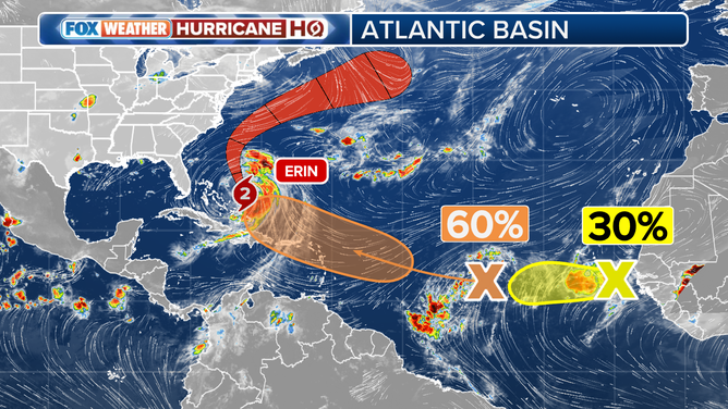
This graphic shows an overview of the tropics in the Atlantic Basin on Tuesday, August 19, 2025.
(FOX Weather / FOX Weather)
Development odds grow for an area to watch right behind Hurricane Erin
The first area has been under the eyes of the NHC for a few days as it emerged off Africa's west coast.
The NHC says the large group of disorganized thunderstorms now located in the central tropical Atlantic will encounter favorable conditions for development as it moves toward the Caribbean islands. The NHC says that the system has a medium chance of development over the next seven days.
"Environmental conditions appear conducive for gradual development of this system, and a tropical depression could form late this week or over the weekend while it moves near or north of the northern Leeward Islands," the NHC said in its Tuesday evening outlook.

(FOX Weather)
FOX Weather Hurricane Specialist Bryan Norcross says it's still too early to know where this system will track if it develops.
"The system's path over next weekend and into next week is an open question," Norcross wrote on Monday.
"The computer forecasts have been flopping around, although the consensus is that the system will follow Erin to the north well offshore of the U.S. East Coast."
BRYAN NORCROSS: ERIN LIKELY TO BRUSH EAST COAST, CAUSE DANGEROUS CONDITIONS ALONG BEACHES

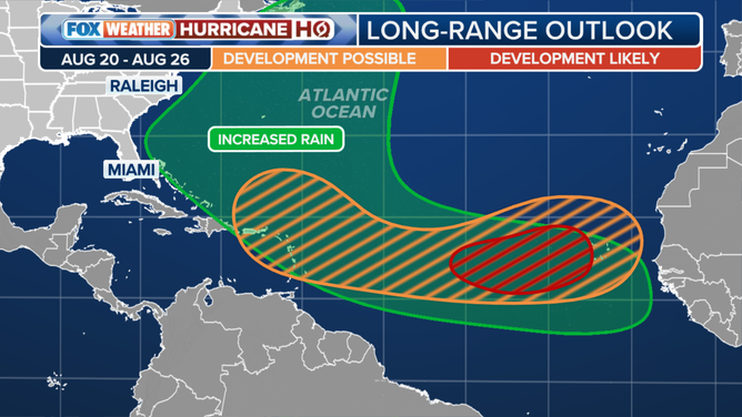
The tropical long-range outlook for development through Aug. 26.
(FOX Weather)
The next name on the 2025 Atlantic hurricane season list is Fernand.
Invest 99L tagged as area of storms emerges off Africa
Invest 99L was designated by the NHC off the coast of Africa early Tuesday morning.
An invest is a term used by the NHC to designate an area they are investigating for possible development into a tropical depression or tropical storm within the next seven days.
The invest designation allows the NHC to run specialized computer forecast models on the system to obtain more information about its future track and intensity.
WHAT IS AN INVEST DURING HURRICANE SEASON?

(FOX Weather)
A tropical wave "continues to produce shower and thunderstorm activity while it moves westward at about 15 mph," the NHC wrote Tuesday evening. "A short-lived tropical depression could form during the next day or two before unfavorable environmental conditions develop late this week."
However, this system currently only has a low chance of development over the next seven days.
Should that storm find favorable conditions to eventually develop into a tropical storm, it would earn the name Gabrielle.
The FOX Forecast Center will continue to watch these areas throughout the week as the peak of hurricane season approaches on Sept. 10.
