Tropical Storm, Storm Surge Watches issued for North Carolina coast from Hurricane Erin’s vicious outer bands
Hurricane Erin rapidly intensified over the weekend, going from a Category 1 hurricane to a catastrophic Category 5 hurricane with winds of 160 mph in a matter of hours. Tropical Storm and Storm Surge Watches are in place for parts of the North Carolina coast due to Erin's intensifying outer bands.

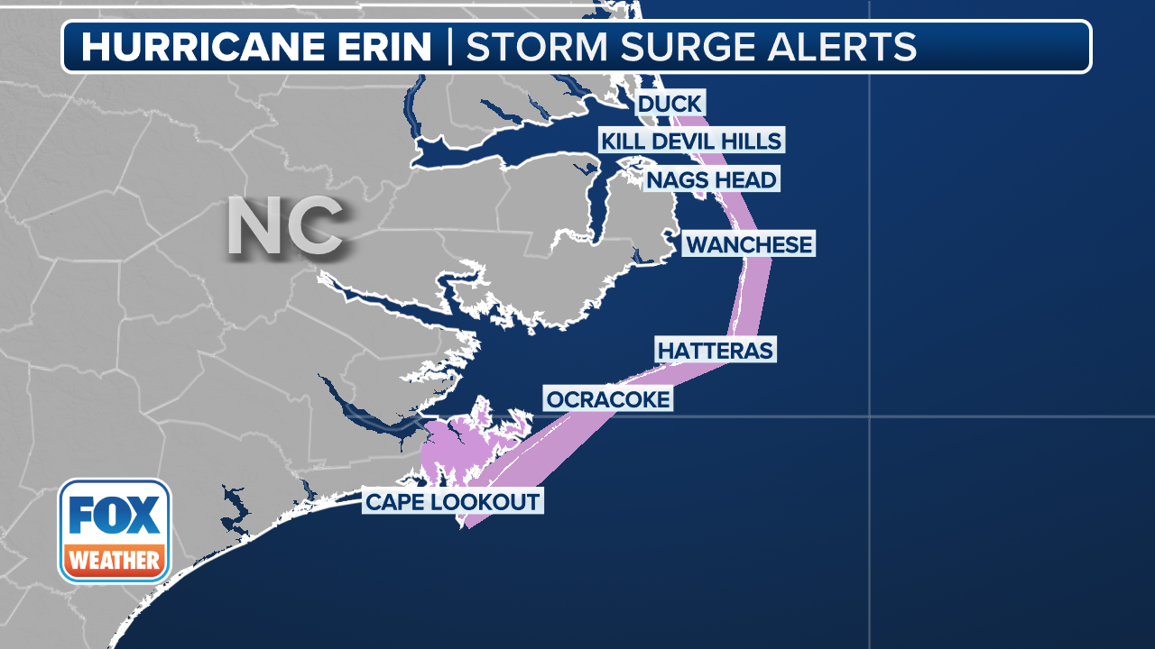
Tropical Storm and Storm Surge Watch issued for the North Carolina Outer Banks
FOX Weather Meteorologist Ian Oliver breaks down the latest update from the National Hurricane Center, as a tropical storm surge and watch has been issued for North Carolina's Outer Banks.
HATTERAS, N.C. – Tropical Storm and Storm Surge Watches have been issued for portions of North Carolina’s Outer Banks as extremely dangerous Hurricane Erin continues to barrel across the Atlantic as a major Category 4 hurricane.
While the powerful center of Erin is expected to remain hundreds of miles offshore, the outer bands of the massive storm could lash the North Carolina coastline with tropical storm-force winds as it passes by later this week, prompting the watch from Beaufort Inlet to Duck, North Carolina, including Pamlico Sound.

Tropical Storm Watch for North Carolina due to Hurricane Erin.
(w / FOX Weather)
A Storm Surge Watch is also in place for Cape Lookout to Duck, North Carolina, as the combination of a dangerous storm surge of 2-4 feet and the tide will cause normally dry areas near the coast to be flooded by rising waters moving inland from the shoreline.
(FOX Weather)
Minor storm surge of 1-3 feet is possible along the southern North Carolina Coast to the South Santee River in South Carolina, and from Duck, North Carolina north into the Tidewater areas of Virginia.
Local officials in North Carolina declared local states of emergency and issued mandatory evacuations for some communities due to life-threatening impacts from the monster storm.
![This image provided by the North Carolina Department of Transportation shows a line of vehicles waiting to evacuate Ocracoke Island ahead of life-threatening impacts from Hurricane Erin.]() Image 1 of 13
Image 1 of 13This image provided by the North Carolina Department of Transportation shows a line of vehicles waiting to evacuate Ocracoke Island ahead of life-threatening impacts from Hurricane Erin. (North Carolina Department of Transportation)
![This image provided by the North Carolina Department of Transportation shows a line of vehicles waiting to evacuate Ocracoke Island ahead of life-threatening impacts from Hurricane Erin.]() Image 2 of 13
Image 2 of 13This image provided by the North Carolina Department of Transportation shows a line of vehicles waiting to evacuate Ocracoke Island ahead of life-threatening impacts from Hurricane Erin. (North Carolina Department of Transportation)
![A surfer rides a wave at La Pared beach as Category 5 Hurricane Erin approaches in Luquillo, Puerto Rico on August 16, 2025. Hurricane Erin rapidly strengthened offshore to a "catastrophic" Category 5 storm on August 16, as rain lashed Caribbean islands and weather officials warned of possible flash floods and landslides. The first hurricane of what is expected to be a particularly intense Atlantic season, Erin is expected to drench Caribbean islands with rain and strong winds but not make landfall.]() Image 3 of 13
Image 3 of 13A surfer rides a wave at La Pared beach as Category 5 Hurricane Erin approaches in Luquillo, Puerto Rico on August 16, 2025. Hurricane Erin rapidly strengthened offshore to a "catastrophic" Category 5 storm on August 16, as rain lashed Caribbean islands and weather officials warned of possible flash floods and landslides. The first hurricane of what is expected to be a particularly intense Atlantic season, Erin is expected to drench Caribbean islands with rain and strong winds but not make landfall. (RICARDO ARDUENGO/AFP)
![A surfer rides a wave at La Pared beach as Category 5 Hurricane Erin approaches in Luquillo, Puerto Rico on August 16, 2025. Hurricane Erin rapidly strengthened offshore to a "catastrophic" Category 5 storm on August 16, as rain lashed Caribbean islands and weather officials warned of possible flash floods and landslides.]() Image 4 of 13
Image 4 of 13A surfer rides a wave at La Pared beach as Category 5 Hurricane Erin approaches in Luquillo, Puerto Rico on August 16, 2025. Hurricane Erin rapidly strengthened offshore to a "catastrophic" Category 5 storm on August 16, as rain lashed Caribbean islands and weather officials warned of possible flash floods and landslides. (RICARDO ARDUENGO/AFP)
![This photo shows power lines that were brought down as a result of Hurricane Erin's winds in Puerto Rico on Aug. 17, 2025.]() Image 5 of 13
Image 5 of 13This photo shows power lines that were brought down as a result of Hurricane Erin's winds in Puerto Rico on Aug. 17, 2025. (@lumaenergypr/X)
![This image shows trees that were brought down as a result of Hurricane Erin's winds in Puerto Rico on Aug. 17, 2025.]() Image 6 of 13
Image 6 of 13This image shows trees that were brought down as a result of Hurricane Erin's winds in Puerto Rico on Aug. 17, 2025. (@lumaenergypr/X)
![Heavy waves are seen at La Pared beach as Category 5 Hurricane Erin approaches in Luquillo, Puerto Rico on August 16, 2025. Hurricane Erin rapidly strengthened offshore to a "catastrophic" Category 5 storm on August 16, as rain lashed Caribbean islands and weather officials warned of possible flash floods and landslides. The first hurricane of what is expected to be a particularly intense Atlantic season, Erin is expected to drench Caribbean islands with rain and strong winds but not make landfall. (Photo by Ricardo ARDUENGO / AFP) (Photo by RICARDO ARDUENGO/AFP via Getty Images)]() Image 7 of 13
Image 7 of 13Heavy waves are seen at La Pared beach as Category 5 Hurricane Erin approaches in Luquillo, Puerto Rico on August 16, 2025. Hurricane Erin rapidly strengthened offshore to a "catastrophic" Category 5 storm on August 16, as rain lashed Caribbean islands and weather officials warned of possible flash floods and landslides. The first hurricane of what is expected to be a particularly intense Atlantic season, Erin is expected to drench Caribbean islands with rain and strong winds but not make landfall. (Photo by Ricardo ARDUENGO / AFP) (Photo by RICARDO ARDUENGO/AFP via Getty Images) ( )
![Waves hit a structure as Category 5 Hurricane Erin approaches in San Juan, Puerto Rico, on August 16, 2025. Hurricane Erin on Saturday strengthened to a "catastrophic" Category 5 storm as it barrelled towards the Caribbean, with weather officials warning of possible flash floods and landslides. (Photo by Ricardo ARDUENGO / AFP) (Photo by RICARDO ARDUENGO/AFP via Getty Images)]() Image 8 of 13
Image 8 of 13Waves hit a structure as Category 5 Hurricane Erin approaches in San Juan, Puerto Rico, on August 16, 2025. Hurricane Erin on Saturday strengthened to a "catastrophic" Category 5 storm as it barrelled towards the Caribbean, with weather officials warning of possible flash floods and landslides. (Photo by Ricardo ARDUENGO / AFP) (Photo by RICARDO ARDUENGO/AFP via Getty Images) ( )
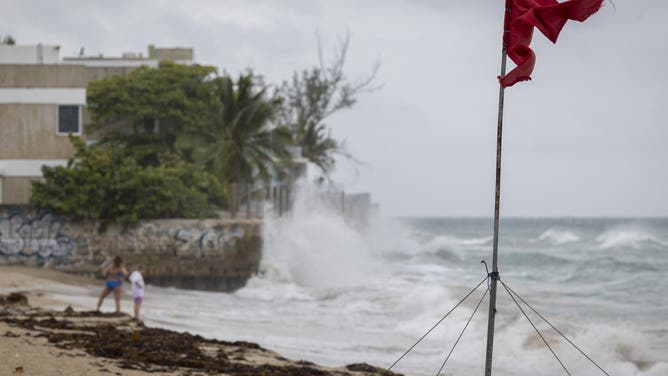
![A ripped red flag warning of rip current waves as Category 5 Hurricane Erin approaches in San Juan, Puerto Rico, on August 16, 2025. Hurricane Erin on Saturday strengthened to a "catastrophic" Category 5 storm as it barrelled towards the Caribbean, with weather officials warning of possible flash floods and landslides. (Photo by Ricardo ARDUENGO / AFP) (Photo by RICARDO ARDUENGO/AFP via Getty Images)]() Image 9 of 13
Image 9 of 13A ripped red flag warning of rip current waves as Category 5 Hurricane Erin approaches in San Juan, Puerto Rico, on August 16, 2025. Hurricane Erin on Saturday strengthened to a "catastrophic" Category 5 storm as it barrelled towards the Caribbean, with weather officials warning of possible flash floods and landslides. (Photo by Ricardo ARDUENGO / AFP) (Photo by RICARDO ARDUENGO/AFP via Getty Images) ( )
![Rain lashes St. Thomas as Hurricane Erin moves north of the U.S. Virgin Islands on Saturday.]() Image 10 of 13
Image 10 of 13Rain lashes St. Thomas as Hurricane Erin moves north of the U.S. Virgin Islands on Saturday. (Robert Ray)
![Rain lashes St. Thomas as Hurricane Erin moves north of the U.S. Virgin Islands on Saturday.]() Image 11 of 13
Image 11 of 13Rain lashes St. Thomas as Hurricane Erin moves north of the U.S. Virgin Islands on Saturday. (Robert Ray)
![Rain lashes St. Thomas as Hurricane Erin moves north of the U.S. Virgin Islands on Saturday.]() Image 12 of 13
Image 12 of 13Rain lashes St. Thomas as Hurricane Erin moves north of the U.S. Virgin Islands on Saturday. (Robert Ray)
![Rain lashes St. Thomas as Hurricane Erin moves north of the U.S. Virgin Islands on Saturday.]() Image 13 of 13
Image 13 of 13Rain lashes St. Thomas as Hurricane Erin moves north of the U.S. Virgin Islands on Saturday. (Robert Ray)


Hurricane Erin’s outer rainbands have begun lashing the southeastern Bahamas and the Turks and Caicos Islands, where Tropical Storm Warnings remain in effect. A Tropical Storm Watch was issued for the central Bahamas on Monday morning.
And while the monster storm will likely stay to the east of the U.S., officials are warning of life-threatening surf and rip currents at beaches up and down the East Coast from Florida in the Southeast through the mid-Atlantic, Northeast and New England this week.
A spokesperson for Wrightsville Beach, North Carolina, told FOX Weather their rescue crews have made nearly 60 water rescues so far on Monday due to strong rip currents. The town has now told all beachgoers to stay out of the water from Tuesday through Friday as Erin gets even closer.
"These swells are producing powerful rip currents that can create extremely hazardous swimming conditions," said Sam Proffitt, director of Wrightsville Beach Ocean Rescue. "The safety of our beachgoers is always our top priority, and we urge everyone to follow this advisory."

(FOX Weather)
On Sunday, officials in Dare County, North Carolina, declared a state of emergency and issued a mandatory evacuation for Hatteras Island, including unincorporated villages of Rodanthe, Waves, Salvo, Avon, Buxton, Frisco and Hatteras.
"Now is the time to secure property, finalize plans and evacuate with belongings," officials said in a Facebook post. "Please follow instructions from officials and property managers."

Watch: Views above Hatteras Island ahead of Hurricane Erin’s impacts in North Carolina
A video shared by FOX Weather Storm Specialist Mike Seidel shows Hatteras Island, North Carolina, from the air on Sunday, Aug. 18, ahead of impacts from Hurricane Erin later this week.
A similar situation unfolded in nearby Hyde County, where the Board of Commissioners enacted a state of emergency for Ocracoke Island due to anticipated flooding impacts from Hurricane Erin.
In addition, a mandatory evacuation order was issued for visitors that started at 8 p.m. Sunday, and for residents starting at 6 a.m. Tuesday.
"While Hurricane Erin is expected to stay well off our coast, the system will continue to increase in size and is forecast to bring life-threatening impacts to the Ocracoke coastline and render Highway 12 impassable," officials said in a statement.

Watch: Evacuations underway in North Carolina as Hurricane Erin spins across Atlantic
A video shared from Nags Head, North Carolina, shows evacuations underway due to the expected impacts from Hurricane Erin later this week.
To help with evacuations, the North Carolina Ferry System said ferries to Hatteras, Cedar Island and Swan Quarter will be running their full schedules until the evacuation process is complete to help keep people safe.
"Please know that at this point, we expect that there will be times in the next week that NC12 on the north end of Ocracoke will become impassable due to significant ocean overwash," officials said. "In a worst-case scenario, the highway could be closed for several days. Please heed the evacuation orders and keep you and your family safe."
North Carolina Gov. Josh Stein has urged his residents to prepare for the impacts of Hurricane Erin.
"Local states of emergency have been issued in Dare and Hyde counties, with mandatory evacuations for Ocracoke and Hatteras islands," he said in a Facebook post. "North Carolinians along the coast should prepare for dangerous surf and rip currents and coastal flooding throughout the week."
The National Weather Service office in Newport/Morehead City issued a High Surf Advisory and Coastal Flood Watch in advance of Hurricane Erin’s impacts.
"Extreme beach and coastal damage is likely along the oceanside, resulting in a significant threat to life and property," the NWS Newport-Morehead City said. "Large dangerous waves will likely inundate and destroy protective dune structures."
The NWS said large breaking waves of 7-12 feet are expected in the surf zone, and "significant oceanside inundation" above ground level is likely in the low-lying areas near the shore and in tidal waterways.

(FOX Weather)
As of the latest advisory from the National Hurricane Center (NHC), Hurricane Erin has maximum sustained winds of 130 mph -- a drop from earlier in the day but still remains a Category 4 hurricane on the Saffir-Simpson Hurricane Wind Scale.
Erin, which became the first major hurricane of the 2025 Atlantic hurricane season, is no doubt going to be a storm for the history books. The powerful storm rapidly intensified over the weekend, going from a Category 1 hurricane to a catastrophic Category 5 hurricane with winds of 160 mph in a matter of hours.
The NHC said that some additional strengthening is expected on Monday, and forecasters say Hurricane Erin will remain a "dangerous major hurricane" through the middle of the week.
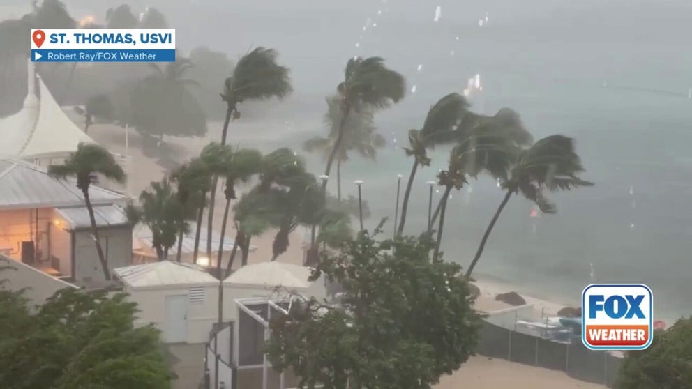
Watch: Palm trees sway, thunder claps on St. Thomas as Hurricane Erin passes to the north
A video shared by FOX Weather Correspondent Robert Ray shared this video showing heavy rain and strong winds on St. Thomas as Hurricane Erin moved to the north. In the video you can see palm trees swaying in the wind and you can head a loud clap of thunder as heavy rain falls.
"Even though some weakening is forecast beginning (Monday night), Erin will remain a large and dangerous major hurricane through the middle of the week," the NHC wrote.
Hurricane Erin is a massive system.
The NHC said that hurricane-force winds extend outward up to 80 miles, while tropical-storm-force winds extend outward up to 230 miles.
DOWNLOAD THE FREE FOX WEATHER APP

(FOX Weather)
Hurricane Erin is currently located about 805 miles south-southeast of Cape Hatteras, North Carolina, and was moving off to the northwest at 10 mph.
The NHC said that Hurricane Erin should make a gradual turn toward the north later Monday and into Tuesday.
On that track, the NHC said the center of Hurricane Erin is expected to pass to the east of the southeastern Bahamas on Monday and move between the U.S. East Coast and Bermuda by the middle of the week.
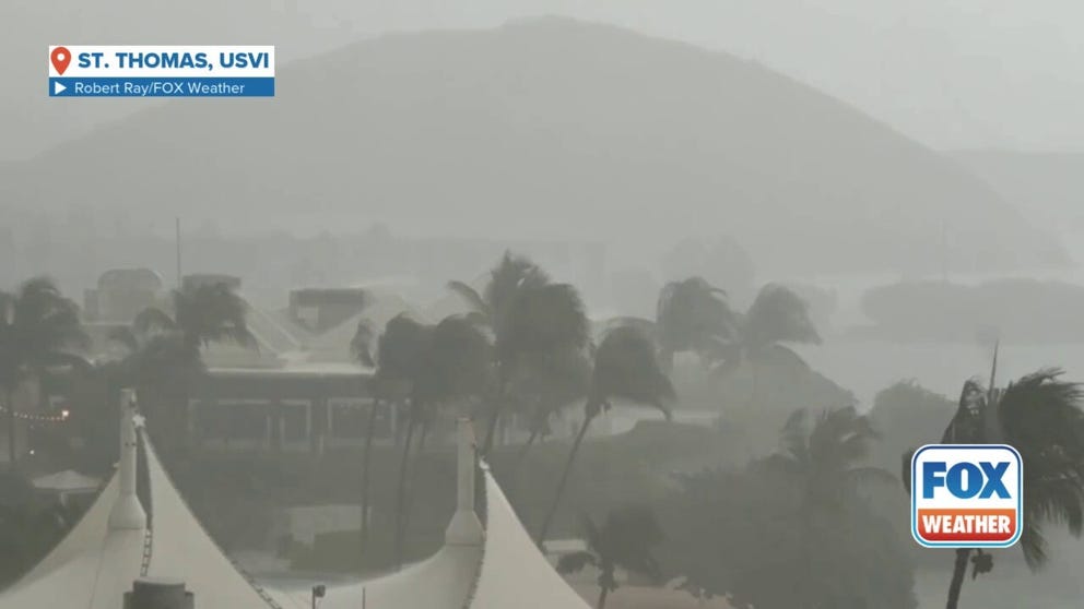
Watch: Heavy rain, strong winds lash St. Thomas as Hurricane Erin moves north of US Virgin Islands
FOX Weather Correspondent Robert Ray shared this video of strong winds and heavy rain on St. Thomas in the U.S. Virgin Islands as Hurricane Erin passed to the north on Saturday, Aug. 17, 2025.
The outer bands from Hurricane Erin will produce locally heavy rain across portions of Hispaniola through Monday, and through Tuesday for the Turks and Caicos Islands and portions of the southeastern Bahamas.
Additional rainfall amounts of 2-4 inches are possible, with locally higher amounts of up to 6 inches not out of the question.

(FOX Weather)
Swells generated by Hurricane Erin will impact the Bahamas, Bermuda, the East Coast of the U.S. and Atlantic Canada over the next several days.
Those dangerous conditions will likely cause life-threatening surf and rip currents.
A storm surge could also cause minor coastal flooding in areas of onshore winds in the Turks and Caicos Islands and in the southeastern Bahamas.
Hurricane Erin slams Caribbean with high winds, flooding rain
It was a tense weekend for residents in the Caribbean, including Puerto Rico and the U.S. Virgin Islands, as Hurricane Erin scooted by to the north.

Watch: Wild winds whip across Puerto Rico as Hurricane Erin spins north of the island
A video shared from Puerto Rico shows foggy conditions as heavy rain fell and winds whipped across the island as Hurricane Erin spun off to the north.
The hurricane didn’t make landfall and stayed well north of the islands, but impacts were widely felt across the region. More than 10 inches of rain fell across Tortola in the British Virgin Islands, while several areas of Puerto Rico picked up more than 4 inches of rain. Thousands of power outages were also reported in Puerto Rico and several flights were canceled as gusts reached up to 65 mph.