Weekend Weather Wows: Oklahoma's rare storm dance, Minnesota's snows, Green Bay's exploding tree
Fort Lauderdale got plenty of rain, Duluth got record amounts of snow, and a poor tree in Wisconsin found out what it's like to be blasted with 50,000 degrees of nature's wrath.

Magnificent ground to cloud lightning spotted in Houston, TX this week
Some magnificent ground to cloud lightning spotted in Houston, Texas earlier this week. (Credit: Charles Michael Falgout via Storyful)
DULUTH, Minn. – You probably heard that it snows in Minnesota, rains sometimes in tropical south Florida and the occasional severe thunderstorm rolls through the Midwest, but the storms of the past few weeks have had a unique twist.
Welcome to our new weekly feature, "Weekend Weather Wows," where we'll go back and find the most interesting tidbits of weather you might have missed over the past week, so you'll be ready to impress at the water cooler (or virtual water cooler) come Monday.
Minnesota: We have too much snow … and we know that sounds nuts
Breaking news: It snowed in Minnesota this winter. While parts of the Northeast were nearly shutout of winter fun, several towns in Minnesota had among their Top 5 snowiest winters.
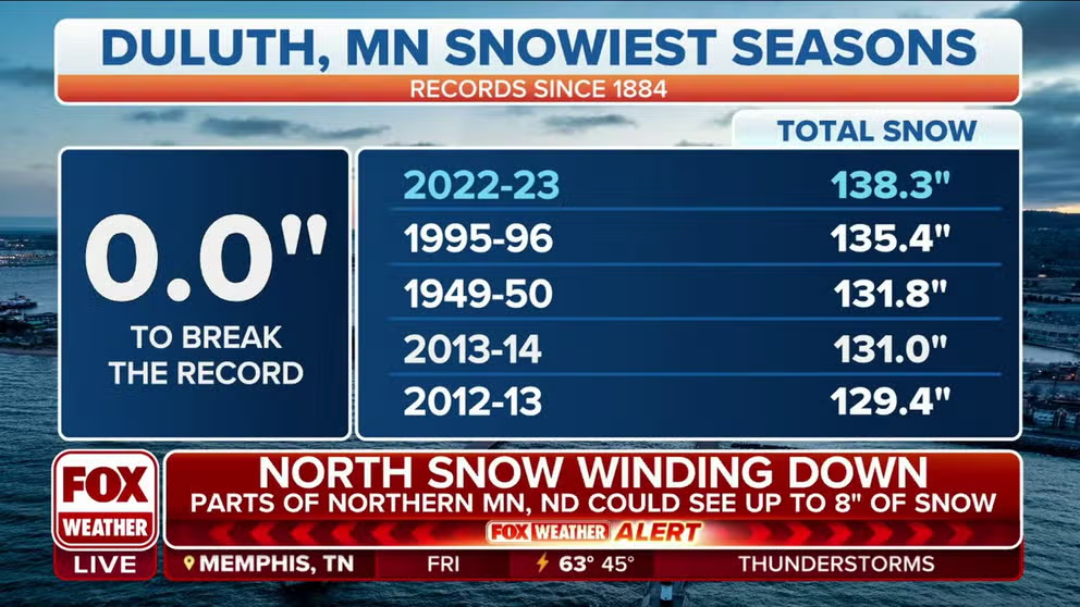
Duluth, Minnesota sets record for their snowiest season ever with over 138 inches of total snow
With 138.3 inches of snow, this season beat out the previous record holder – the winter of 1995-1996, which had 135.4 inches of snow.
But in Duluth, it's now THE snowiest winter. Snow this week has pushed their winter snowfall this season to 138.3 inches of snow, breaking their old record by 3.1 inches set in 1995-96.
Minneapolis sits in third place this year for their snowiest winter.
Green Bay NWS blowing up your Twitter feed
We've highlighted the power of rain and snow; how about the power of five suns?!? A poor tree in the Green Bay area knows the feeling.
Severe thunderstorms rolled across much of the Midwest last week, with one potent thunderstorm taking out its wrath on this tree in Hobart, Wisconsin.
Did you know lightning bolts can reach temperatures of 50,000 degrees? That's about five times hotter than the surface of the sun, according to the National Weather Service (though the core of the sun is considerably hotter)... or only about 2.3 times the heat the Packers are getting over the whole Aaron Rodgers trade drama.
DEBUNKING 7 MYTHS ABOUT LIGHTNING
If the tree is wet, the water inside the bark will instantly boil and explode, creating the incredible pressure that leads to the explosion.
Meteorologists wowed by Oklahoma storms
Consider this column the second time this week some meteorologists have been officially ‘wow'ed. A cluster of severe storms and supercells exhibited two rare phonomenon… in the same storm!
The first rarity was a tornadic storm taking a "deviant" turn from its typical west-to-east motion. The tornado Wednesday night instead took a sharp turn to the north as it approached Shawnee.

Doppler radar analysis of a tornado that swept through Oklahoma on April 19, 2023.
(FOX Weather)
Second jaw-dropper: As the cluster of supercells moved toward Shawnee, Oklahoma, two areas of rotation began spinning around each other, like two figure skaters going in for a hug.
The phenomenon is known as the Fujiwhara Effect and can be seen when two cyclonic systems drift near each other.
"This is more common with hurricanes, but it can happen on a small scale, such as tornadoes," said FOX Weather Meteorologist Jordan Overton. "The stronger spin 'wins' the battle, and eventually either pulls the smaller spin into it, or the smaller spin dissipates or swings off in a direction outside the main spin of both."
That's no moon
Speaking of Oklahoma supercells, most of the time national weather forecasters sit at their computers and forecast the weather for someone else. But this ominous supercell thunderstorm that came right to the doorstep of those tasked with tracking their developments. That building in the foreground is NOAA's Storm Prediction Center in Norman, Oklahoma.

A supercell thunderstorm drifts by the National Weather Service office in Norman, Oklahoma.
(National Weather Service / NOAA)
Some of the forecasters there wrote about the impending storms-- then went out and verified their forecast in real time!

Storm Prediction Center meteorologist tracks central Oklahoma tornado after issuing forecast
Meteorologist Emily Thornton with the NWS Norman Storm Prediction Center wrote the forecasts for the Oklahoma tornadoes and then verified her forecasts hands-on by chasing the tornadoes.
Then as the storms moved east, ominous mammatus clouds turned a gloomy rain-delayed start to the Chicago Cubs game Thursday night against Los Angeles into the ballpark sunset of the year so far.

Dramatic Wrigley Field Sunset
A stunning display of mammatus clouds graced Chicago's Wrigley Field just as the Cubs' game against the Los Angeles Dodgers was getting under way Thursday evening.
The gloom would return when the Cubs bullpen gave up a grand slam to lose the game in the 8th, but skies were brighter literally and figuratively the next day when they nearly pitched a perfect game in their 13-0 revenge thumping of the Dodgers Friday on a much sunnier afternoon.
There's a little black spot on the sun today
Japan's Himawari 9 weather satellite patrolling the western Pacific Ocean witnessed two rare events in congruence on Thursday afternoon -- a tropical storm that sat right in the path of a solar eclipse.
If you look close, you can see the moon cast its shadow across western Australia from bottom left to upper right. (The large black line of darkness approaching from the right side isn't some mega moon it's just…the impending darkness of the day as the hours turn to night.)
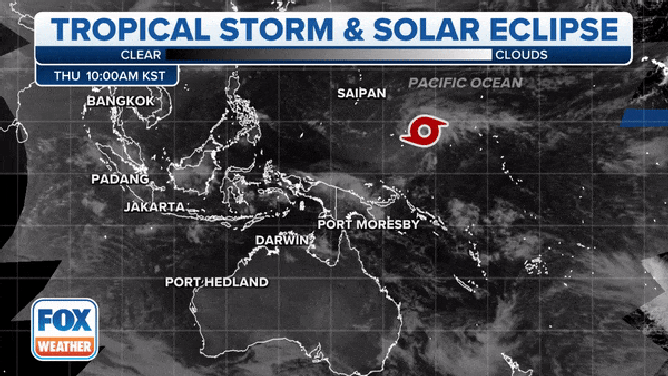
Japan's Himawari 9 satellite captures the shadow of a solar eclipse moving across the Pacific Ocean, touching a rare early-season Tropical Storm (Sanvu).
(FOX Weather)
Tropical Storm Sanvu briefly reached 50 mph as peak speed as it churned in the Pacific but was fizzling this weekend.
I can't take all this rain, I'm moving to Seattle …
File this under "ICYMI": Usually, this column will only go back over the previous week's weather tidbits, but I was off week-before-last spending some in Fort Lauderdale, Florida, area for spring break and … yes, exquisite timing as it rained nearly the whole week.
Although "rain" is a decent understatement. So is "poured." And "drenched" and … well, just find an adjective you like here.

Drone video of downtown Fort Lauderdale captures extent of flooding
Drone video of downtown Fort Lauderdale shows countless cars trapped in high water after the city experienced extreme flooding on Wednesday.
As you may have heard, thunderstorms just parked over the town, delivering rain measured in feet instead of inches and causing widespread flooding. But how much rain fell amazes me to this day, especially when you consider it wasn't at the hand of a hurricane or tropical storm. Just stubborn thunderstorms.
Fort Lauderdale's official rain gauge at the airport was already having issues before the big storm, but then the area around the weather station flooded, according to the National Weather Service so we may have lost the official measurement. However, a nearby rain gauge provided by WeatherSTEM did function through the event and recorded incredible rainfall accumulations!
The area received 20.42 inches in one day (April 13) and 26.97 inches over a two-day period. Some of the rainfall rates recorded were 0.18 inches per minute which works out to about 0.01 inches of rain every 3 seconds! A town in the Atacama Desert in Chile once went 17 years without even that little morsel of rain.
It's possible enough of that fell over a 24-hour period to set the Florida state record for 24-hour rainfall at 23.28 inches, but it'll be up to NOAA's State Climate Extremes Committee to accept whether this gauge's measurements from the storm conform to the high standards of official data.
But the storms kept coming. Fort Lauderdale is now up to just under 35 inches of rain since April 9. That's more rain than Seattle saw in all of 2019!
And no, I didn't bring the rain with me from Seattle. Some quick calculations show it'd take over 630,000 Boeing 747 cargo jets to deliver 30 inches of rain to all of Fort Lauderdale. If I get the first 50 pounds "free" that's only about, oh, $6.2 billion in overweight luggage fees. So sorry Florida, your rain is home-grown. Besides, it's still raining out here…
Other weather tidbits from the week:
- You've probably heard of dust devils, but in Montana, there were sightings of "steam devils". "Steam devils develop as wet ground rapidly heats, with air above remaining relatively cold," said the National Weather Service:

A steam devil is seen on a lake behind near the National Weather Service office in Missoula, Montana
(National Weather Service, Missoula, Montana / NOAA)
- Utah's Alta Ski Resort is in 900 watch: As in 900 inches of seasonal snowfall. They're at 893 inches now with some snow in the forecast this week. Grab your skies and the popcorn! (Well, maybe the popcorn first…)