Tornado damage reported in Texas as powerful storm system shifts East, snarling holiday travel
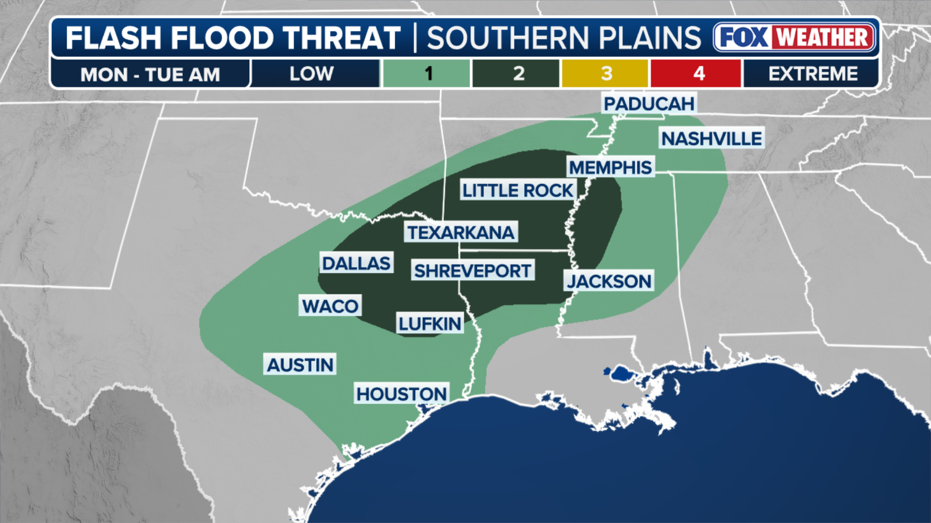
More severe storms are expected to threaten early Thanksgiving flights in these same areas on Monday afternoon, as storms begin to shift east. A broad low-level flash flood threat stretches from Austin to Nashville, Tennessee.

Confirmed tornado north of Houston
FOX Weather Exclusive Storm Tracker Corey Gerken joins the show to discuss the latest severe weather alerts, as a tornado was confirmed north of Houston today. Gerken is on the move, continuing to follow the storm.
DALLAS – A line of thunderstorms blasted through North Texas, Oklahoma and Arkansas Monday, bringing powerful wind gusts and heavy rain to the Interstate 20 and Interstate 35 corridors, as an estimated 73 million people begin to travel for the Thanksgiving holiday.
LATEST THANKSGIVING WEEK STORM LIVE TRACKER: RADAR, FLIGHT DELAYS AND CANCELLATIONS AND FORECASTS
More severe storms are firing in these same areas throughout the evening as storms begin to shift east. A broad low-level flash flood threat stretches from Austin to Nashville, Tennessee.
Tornado touching down off 249 #HoustonTornado pic.twitter.com/j5D0zICpZo
— Grayson Moore (GO X) (@GMooreIV) November 24, 2025
Damage to both homes and properties was seen throughout Harris County, Texas.
According to the FOX Forecast Center, drivers traveling Interstate 20 from Shreveport, Louisiana to Alexandria, Louisiana will likely see the worst impacts from those storms.
My Constable deputies are on the ground with EMS/Fire in the 8000 blk of Summer Grove Circle where a tornado has damaged homes and property. First responders are checking homes to ensure citizens are OK. Comm. Ramsey’s has been informed and has crews on the way. pic.twitter.com/bpwnUX4BiN
— Mark Herman, Harris County Constable Precinct 4 (@Pct4Constable) November 24, 2025
NOAA's Storm Prediction Center has issued a Level 2 out of 5 risk of severe thunderstorms covering parts of East Texas, northern Louisiana, southern Arkansas, and eastern Mississippi.
Houston is just outside the Level 2 risk but could still continue to see strong storms Monday evening.
WHAT IS A SUPERCELL THUNDERSTORM?

Supercell thunderstorm rumbles across Grandfalls, Texas
A supercell thunderstorm rumbled across Grandfalls, Texas Sunday afternoon.
This same weather system delivered powerful severe weather to West Texas, including a supercell thunderstorm in Grandfalls, Texas, on Sunday afternoon.
Supercells are thunderstorms which have the power to produce damaging winds, large hail, and tornadoes.

(FOX Weather)
More than 485 flights were delayed into or out of Dallas Forth Worth International Airport Sunday, according to aviation-tracking company FlightAware.
(FOX Weather)
Meanwhile, a Flood Watch covers parts of North Texas, including the Dallas Metroplex through Monday afternoon, as these storms repeatedly soak many of the same areas.
According to the FOX Forecast Center, most of these areas can expect 1-3 inches of rain through Monday.
WHAT FLASH FLOOD WATCHES, WARNINGS, AND EMERGENCIES REALLY MEAN
The greatest flood threat is concentrated in the Ark-La-Tex region, where NOAA's Weather Prediction Center has issued a Level 2 out of 4 Flash Flood Threat that includes Dallas, Shreveport, Louisiana, Little Rock, Arkansas, Jackson, Mississippi and Memphis, Tennessee.
WHAT ARE THE 10 BUSIEST AIRPORTS THIS THANKSGIVING?
Travel conditions improve for Texas Tuesday as storms shift east, with the heaviest rains blanketing Alabama, Tennessee and parts of Georgia, including Atlanta's Hartsfield-Jackson Airport, the country's busiest airport by volume.