El Nino likely in final weeks as world awaits La Nina and potential jolt to hurricane season
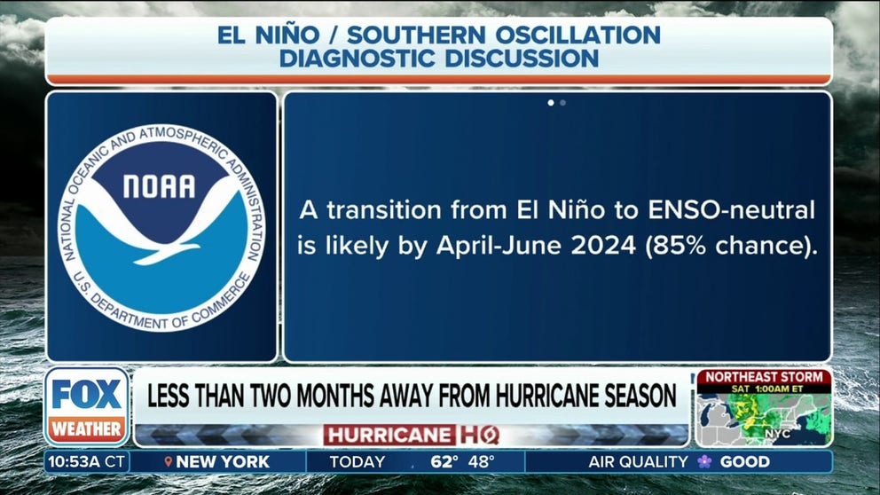
NOAA’s Climate Prediction Center now gives an 85% chance El Niño conditions will be gone when April’s calculations are in next month, with continued cooling in the tropical Pacific likely leading to La Niña conditions by June.
El Nino likely in final weeks as world awaits La Nina and potential jolt to hurricane season
NOAA’s Climate Prediction Center now gives an 85% chance El Niño conditions will be gone when April’s calculations are in next month, with continued cooling in the tropical Pacific likely leading to La Niña conditions by June.
COLLEGE SPRINGS, Md. – El Niño continued its fade from the tropical Pacific Ocean over the past month, loosening its influence on the Earth’s weather patterns and likely entering its final weeks.
NOAA’s Climate Prediction Center now gives an 85% chance El Niño conditions will be gone when April’s calculations are in next month, with continued cooling in the tropical Pacific likely leading to La Niña conditions by June.
WHAT ARE THE EL NINO AND LA NINA PATTERNS?
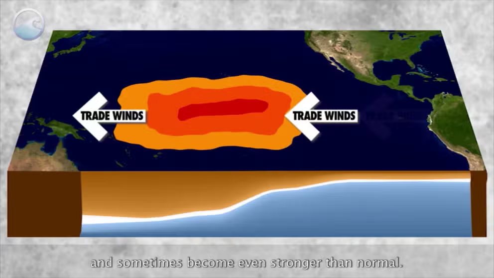
El Niño is declared when water temperatures in the tropical Pacific Ocean are at least 0.5 degrees Celsius (0.9 degrees Fahrenheit) above the long-term average. The current El Niño reached a rare "Super El Niño" status earlier in the winter at 2.0 degrees Celsius (3.4 degrees Fahrenheit) above average but has been in decay since.
The latest measurements were around 1.2 degrees Celsius (2.2 degrees Fahrenheit) above average, but there are plenty of signs in the ocean that waters are cooling below the surface, and forecasts say temperatures will drop below the 0.5-degree Celsius above-average threshold in weeks — triggering what’s known as "neutral conditions." NOAA says there is now a 60% chance the waters will cool to at least 0.5 degrees Celsius below average by the summer, triggering a continued La Niña Watch.
Already there are signs in the tropical weather patterns in the Pacific that El Niño’s influence is weakening, with upper-level wind anomalies and convection near the equator along the International Date Line both abating to near-average levels.
What does La Niña mean for this summer?
Tropical forecasters pay close attention to the El Niño/La Niña phase as it has a frequent influence on the hurricane season. El Niño years tend to enhance the Pacific Ocean hurricane season but suppress the Atlantic hurricane season due to atmospheric conditions that typically produce a lot of storm-thwarting wind shear.
"Last season, the extra-warm water temperatures in the Atlantic were partially canceled out by the somewhat hostile El Niño pattern created by the band of warm water across the equatorial Pacific south of Hawaii," FOX Weather Hurricane Specialist Bryan Norcross said. "Air rising from that large warm-water zone helped create a steering pattern over the tropical Atlantic that kept most of the strong storms away from the U.S. and the Caribbean."
The meaning of El Nino and La Nina
The status of whether the world is being impacted by an El Nino or a La Nina is determined by water temperatures in the central and eastern Pacific. (NOAA)
BYRAN NORCROSS: IS THERE ANY REASON HURRICANE SEASON 2024 WON'T BE SUPER BUSY?
Yet even with El Niño this past season, the Atlantic managed to generate 20 named storms.
La Niña years typically bring the opposite atmospheric conditions, giving a boost to the Atlantic season. And lending an atmospheric assist to a budding Atlantic hurricane season that is already primed to feed off record-warm ocean temperatures is certainly raising eyebrows.
2024 ATLANTIC HURRICANE SEASON COULD BE AMONG MOST ACTIVE ON RECORD, EXPERTS PREDICT
"The ocean water temperatures in the tropical and eastern Atlantic are stunningly warm – the warmest ever recorded at this time of year," Norcross said. "Extra-warm water in the spring usually translates to above-normal temperatures in the heart of hurricane season, so the odds favor developing storms having access to extra energy this year."
Already, Colorado State University’s hurricane forecast for 2024 is predicting 23 named storms, which, if it comes to fruition, would mean the National Hurricane Center would exhaust its tropical storms list for 2024 and would have to dip into a supplemental name list for only the third time since names have been given.
HERE'S WHAT HAPPENS IF WE RUN OUT OF HURRICANE NAMES THIS YEAR
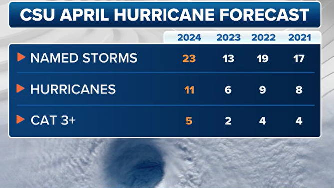
Colorado State University's April forecasts for hurricane season over the past few years.
(FOX Weather)
What does La Niña mean for this winter?
Aside from hurricane season, La Niña would generally predict a flip in the winter weather pattern for the end of this year from what we saw this past winter with El Niño.
Generally speaking, the North has been rather mild with well-below-average snow seasons across the Northwest, northern Plains and Northeast. Meanwhile, the South has nearly wiped out much of its drought with multiple soaking storms rolling through California and into the South.
A La Niña winter traditionally leads to cooler and wetter/snowier conditions across the North, while California and the South typically have a drier-than-average winter.