Tulsa to New Orleans faces risk of hail, damaging winds, flooding rain as storms threaten millions this week
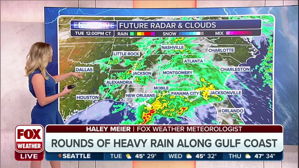
On Tuesday, the severe weather risk will be confined to areas of the South, including Little Rock, Jackson in Mississippi and New Orleans and Shreveport in Louisiana.
Flooding rain, possible severe weather to drench South
An active weather pattern is setting up for parts of the South, bringing the chance of severe weather and flooding rains to areas along the Gulf Coast.
HOUSTON – A busy start to the new workweek is underway for millions of people in the central U.S. as a series of storms will bring the risk of severe weather and flash flooding to cities along the Gulf Coast before heavy precipitation slams the mid-Atlantic to the Northeast later this week.

(FOX Weather)
On Tuesday, the severe weather risk will be confined to areas of the South, including Little Rock, Jackson in Mississippi and New Orleans and Shreveport in Louisiana.
By midweek, the threat of severe weather will push to central and southern Florida, including cities from Orlando to Tampa, Melbourne, West Palm Beach and Miami.

(FOX Weather)
DOWNLOAD THE FREE FOX WEATHER APP
Southern Plains, Deep South face increased severe weather threat Thursday and Friday
![This graphic shows the severe weather threat on Thursday, March 7, 2024.]() Image 1 of 2
Image 1 of 2This graphic shows the severe weather threat on Thursday, March 7, 2024. (FOX Weather)
![This graphic shows the severe weather threat on Friday, March 8, 2024.]() Image 2 of 2
Image 2 of 2This graphic shows the severe weather threat on Friday, March 8, 2024. (FOX Weather)
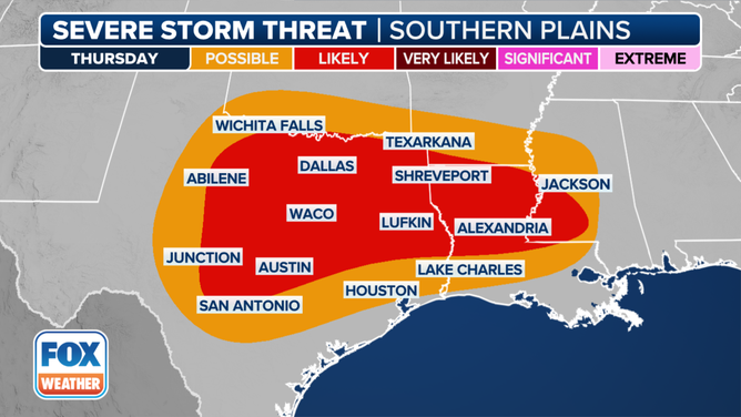
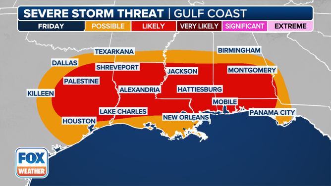
The end of the week could see a higher risk of severe weather from areas of the southern Plains to the Deep South.
As of Monday, the SPC has highlighted nearly 13 million people from Texas to Louisiana and Mississippi in its severe thunderstorm outlook, including Dallas, Waco, Austin and Lufkin in Texas, as well as Shreveport and Alexandria in Louisiana.
On Friday, that severe weather threat expands farther to the east, with areas of East Texas through southern Louisiana, Mississippi and Alabama facing the greatest risk. The Florida Panhandle, too, will see an increased severe weather threat.
WATCH VS. WARNING: HERE ARE THE DIFFERENCES BETWEEN THESE WEATHER TERMS THAT COULD SAVE YOUR LIFE
Heavy rain could lead to flash flooding in the South

(FOX Weather)
NOAA’s Weather Prediction Center (WPC) has highlighted areas of the South and Southeast for the risk of flash flooding due to heavy rain that’s expected to sweep across the region early this week.
The greatest risk on Tuesday is centered over southeastern Louisiana, including New Orleans.

(FOX Weather)
Tuesday’s threat includes cities such as Tupelo in Mississippi, as well as Mobile and Montgomery in Alabama and Atlanta.
Tallahassee, Florida, could also see some flash flooding due to the storms and heavy rain pushing through the region.
EXPLAINING FLOOD ALERTS ISSUED BY NATIONAL WEATHER SERVICE
Mid-Atlantic, Northeast brace for heavy rain, possible flooding

(FOX Weather)
The storm systems responsible for the severe weather and flooding threats in the central part of the country at the start of the week will push into the Northeast by the middle of the week and will combine with an area of low pressure moving up the East Coast off the coast of the Carolinas.
"The next three days, Tuesday, Wednesday and Thursday, are kind of sloppy because we’re tracking the energy again coming from the Midwest," FOX Weather Meteorologist Britta Merwin said. "But then this lifts up to the north as well."
As the low-pressure system spins up the coast and eventually combines with the energy from the cold front pushing in from the Midwest, millions of people along and east of the Interstate 95 corridor from New England to the mid-Atlantic are at risk of picking up a few inches of rain, which could lead to flash flooding.
NATIONAL WEATHER SERVICE REVAMPS FLOOD ALERTS

(FOX Weather)
Between 2 and 3 inches of rain could fall by Thursday along the East Coast from Norfolk in Virginia northward to the Jersey Shore, New York City and southern New England.
There could be as much as 3-5 inches of rain in extreme southern New England, including New London in Connecticut, Providence in Rhode Island and the South Shore of Massachusetts.
HOW HEAVY IS IT REALLY GOING TO RAIN?
Because of the amount of rain expected, there is a risk of flash flooding across the same areas.
That risk extends from the mid-Atlantic to New England and includes cities such as Dover in Delaware, Philadelphia, New York City, Hartford in Connecticut, Nantucket in Massachusetts and Boston.