EF-2 tornado flips cars, leaves damage trail in South Florida as storms race across Sunshine State on Saturday
The first round of storms triggered severe weather warnings and produced an EF-2 tornado packing 130-mph winds in northern Palm Beach County on Saturday. The second round prompted a Tornado Watch for more than 16 million people across the Florida Peninsula and the Keys on Sunday morning.
Tornado flips cars and lashes buildings in South Florida
Severe weather tore across South Florida over the weekend, leading to several Tornado Warnings and at least one confirmed tornado in Palm Beach Gardens.
PALM BEACH GARDENS, Fla. – It's no rest for the weary in Florida this weekend as what has been a very stormy April finishes up with not one, but two rounds of severe weather.
The first round of storms triggered severe weather warnings and produced an EF-2 tornado packing 130-mph winds in northern Palm Beach County on Saturday.
Residents captured video of flipped cars and downed trees after a Tornado Warning expired for the Palm Beach Gardens area around 5:30 p.m. EDT.
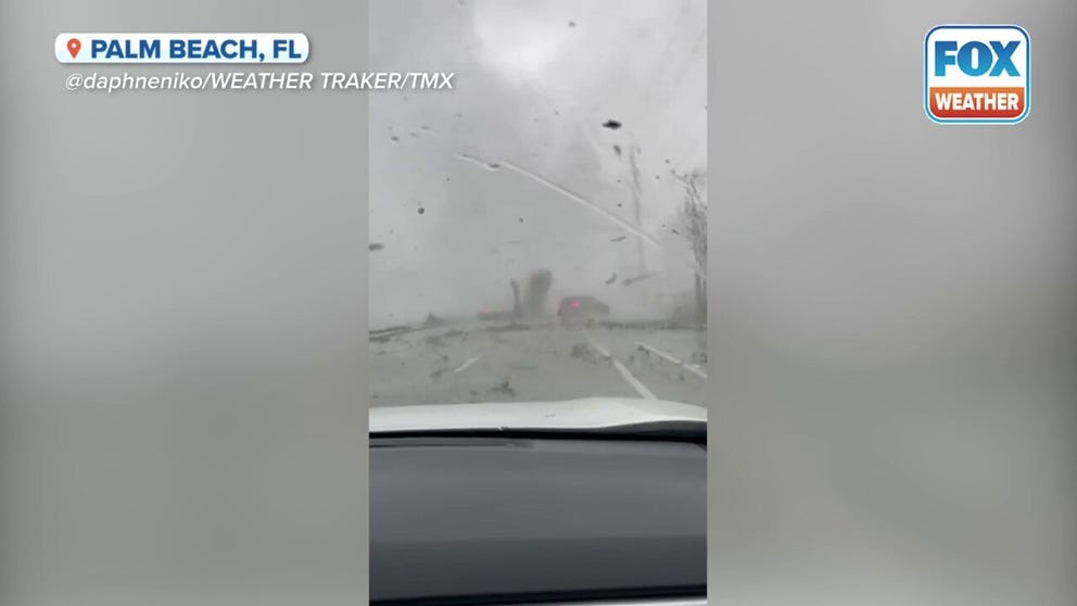
Watch: Car thrown into the air during Florida tornado
A video recorded in Palm Beach, Florida, shows a tornado tossing a car into the air on Saturday, April 29, 2023.
DRAMATIC VIDEO SHOWS CAR TOSSED INTO THE AIR LIKE TOY DURING TORNADO IN FLORIDA
The local police department asked the public to avoid traveling around PGA Boulevard and U.S. 1 due to storm damage.
Several apartment complexes looked to be damaged, and at least one building appeared to have substantial roof damage.
A video recorded in Palm Beach Gardens near the Palm Beach Gardens Medical Center showed leaves and other debris swirling above an apartment complex as the tornado moved closer.
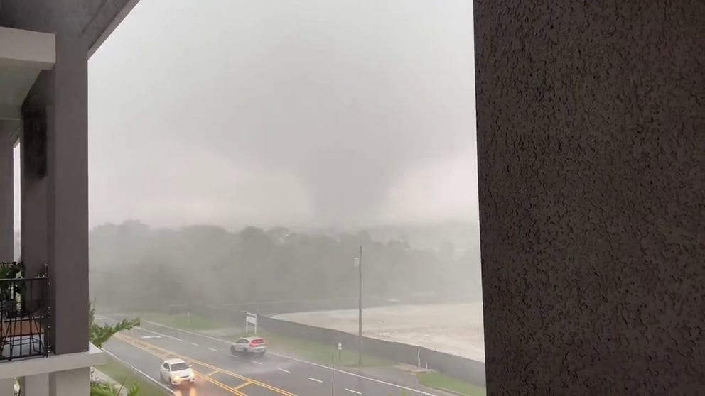
Watch: Man films tornado approaching home in Palm Beach Gardens, Florida
A Florida man recorded an ominous video of a tornado approaching his home in Palm Beach Gardens during severe weather on Saturday, April 29, 2023.
At least 4,000 customers lost electricity in the powerful storm, according to PowerOutage.US.
![Palm Beach Gardens storm damage]() Image 1 of 9
Image 1 of 9Trees were knocked over and several homes were damaged in northern Palm Beach County. (Sharon Jeannette)
![Palm Beach Gardens storm damage]() Image 2 of 9
Image 2 of 9Trees were knocked over and several homes were damaged in northern Palm Beach County. (Sharon Jeannette)
![Palm Beach Gardens storm damage]() Image 3 of 9
Image 3 of 9Trees were knocked over and several homes were damaged in northern Palm Beach County. (Sharon Jeannette)
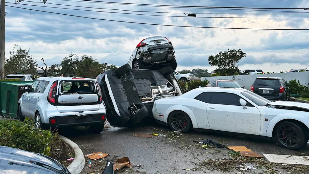
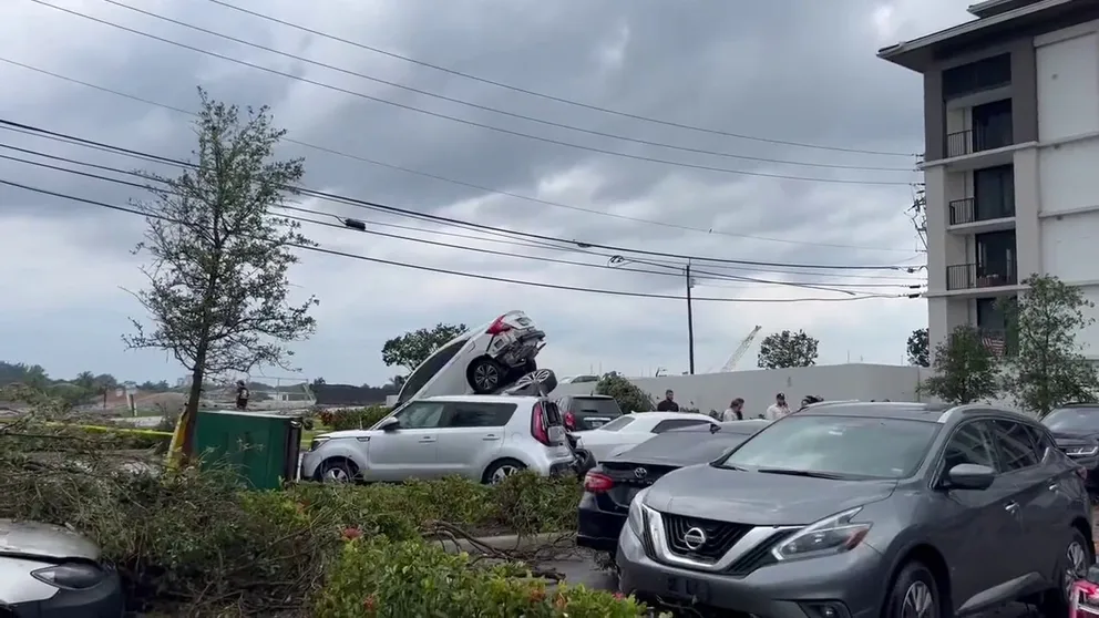
![A pile of cars is seen in a parking lot after a tornado-warned storm moved through Palm Beach Gardens, Florida, on April 29, 2023.]() Image 4 of 9
Image 4 of 9A pile of cars is seen in a parking lot after a tornado-warned storm moved through Palm Beach Gardens, Florida, on April 29, 2023. (Andrew Laybourne/Twitter)
![Apartment complex damage by suspected tornado.]() Image 5 of 9
Image 5 of 9Apartment complex damage by suspected tornado. (Chase Cervantes)
![Apartment complex damage by suspected tornado.]() Image 6 of 9
Image 6 of 9Apartment complex damage by suspected tornado. (Chase Cervantes)
![Apartment complex damage by suspected tornado.]() Image 7 of 9
Image 7 of 9Apartment complex damage by suspected tornado. (Chase Cervantes)
![Apartment complex damage by suspected tornado.]() Image 8 of 9
Image 8 of 9Apartment complex damage by suspected tornado. (Chase Cervantes)
![Apartment complex damage by suspected tornado]() Image 9 of 9
Image 9 of 9Apartment complex damage by suspected tornado. (Chase Cervantes)


More than 11 million residents were under the original Tornado Watch that covered most of the Florida Peninsula during the afternoon and evening.
Another video recorded in Palm Beach Gardens showed the tornado spinning closer to an apartment complex. The man who recorded the video was able to track the twister's movements, but the video cut out as the twister got closer to his location.
Watch: Cars flipped, trees down after tornado in Florida
An EF-1 tornado touched down in Palm Beach Gardens, Florida, on Saturday, and video recorded by Lauren Kreidler shows damage left behind after the twister tore through the community.
After the storms passed, video from the area showed cars on top of each other, picked up by the ferocious winds in the tornado. Other images showed numerous trees and wires that were brought down when the twister moved through the area.
Second round of severe weather rumbled across Florida on Sunday
A second round of severe weather was expected to impact South Florida on Sunday as a trailing cold front finally swept through the Sunshine State.
On Sunday morning, more than 16 million people were placed under a Tornado Watch that included much of the Florida Peninsula and the Keys until 2 p.m. EDT.
The FOX Forecast Center warned strong thunderstorms could contain large hail, damaging wind gusts and even a few tornadoes, with the highest threat running south of Interstate 4, including the cities of Miami, Fort Lauderdale and West Palm Beach.
With an Omega block pattern expected to dominate the country in the week ahead, the weather could turn quieter in Florida after a week full of severe storms.