Winter storm spins across the Upper Midwest after walloping the Plains, Rockies with heavy snow
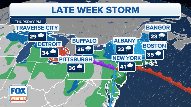
The storm system worked its way into the Upper Midwest and Great Lakes region during the day on Thursday, with the highest impacts seen in Minnesota, central and northern Wisconsin and Michigan.

Meteorologist 'Snowdown': Minneapolis vs. Philadelphia
FOX 9 Minneapolis meteorologist Ian Leonard shows the surplus of snow in Minnesota while FOX 29 Philadelphia meteorologist Kathy Orr reports from the City of Brotherly Love where snow hasn't been seen in 313 days.
GREEN BAY, Wis. – A major winter storm that dropped heavy snow in the Plains and Rockies on Wednesday spun its way across the Upper Midwest and Great Lakes region.
The storm system worked its way into the Upper Midwest and Great Lakes region during the day on Thursday, with the highest impacts seen in Minnesota, central and northern Wisconsin and Michigan.

(FOX Weather)
A stretch of cities across Nebraska and Iowa saw almost 2 feet of snow in places.
By the time the storm system moves out of the region by Friday, a few more inches of snow could fall across central and northeastern Wisconsin, and Michigan’s Upper Peninsula could see an additional 5-8 inches of snow, with perhaps a foot of new snow around Marquette.

(FOX Weather)
Winter Storm Warnings were in effect across portions of southeastern Minnesota, northern Wisconsin and parts of Michigan's Upper Peninsula into late Thursday.
IMAGES SHOW HOW A WINTER STORM IS WALLOPING THE PLAINS, MIDWEST
Northeast got in on the action on late Thursday
Snow moved into the interior Northeast and northern New England, with rain filling in across southern New England, New York City and portions of the I-95 corridor south through Philadelphia, Baltimore and Washington.
OHIO VALLEY IN PATH OF SEVERE STORMS, POSSIBLE TORNADOES ON THURSDAY
![The winter storm forecast on Thursday.]() Image 1 of 2
Image 1 of 2The winter storm forecast on Thursday. ( )
![The winter storm forecast on Friday.]() Image 2 of 2
Image 2 of 2The winter storm forecast on Friday. ( )
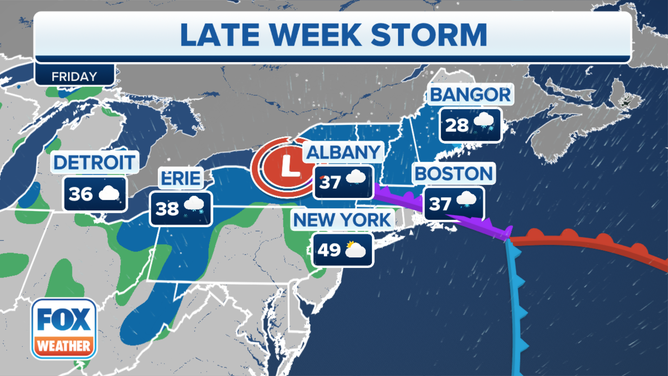
The storm is expected to continue dropping snow across the Northeast and New England as the storm system spins across the region before moving out of the area later on Friday.
EAST COAST WINTER STORM EXPECTED TO BRING IMPACTS TO I-95 CORRIDOR THIS WEEKEND INTO EARLY NEXT WEEK
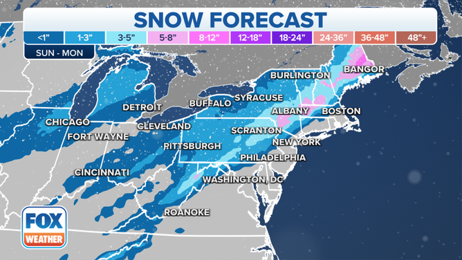
Heavy snow is possible for parts of the interior Northeast between Sunday and Monday.
(FOX Weather)
On the heels of this storm is another that the FOX Forecast Center is keeping an eye on.
A winter storm has its sights set on parts of the East Coast on Sunday, and while rain is expected in Boston, southern New England and the New York City metro area, snow is expected to fall across northern New England and the interior Northeast.
TRAVELING THIS WINTER? HERE'S WHAT TO KEEP IN YOUR CAR IN CASE YOU GET STUCK
Plains walloped with heavy snow on Wednesday

Multi-vehicle crash on I-70 in Colorado on January 18, 2023.
(Colorado State Patrol / Twitter / FOX Weather)
Denver picked up 9.1 inches of snow from the storm Wednesday, which is now the city’s eighth-largest January snowstorm on record. And all that snow led to a massive crash involving at least a dozen vehicles and tractor-trailers on Interstate 70 outside Denver.
According to reports, the crash had minimal injuries, but the mess caused the interstate to be closed for several hours while crews worked to remove the vehicles from the scene.
Several roads and highways remained closed in Colorado Thursday morning, including I-70 in both directions from Denver to the Kansas border and I-76 in both directions from Sterling, Colorado, to the Nebraska border.
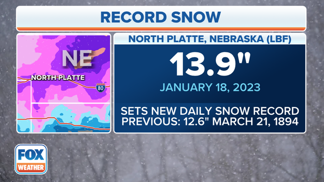
North Platte, Nebraska, set a new daily snow record on Jan. 18, 2023.
(FOX Weather)
And in Nebraska, some areas, like Custer County, picked up nearly two feet of snow from the powerful winter storm. North Platte, Nebraska, picked up 13.9 inches of snow on Wednesday, which set a new daily snow record for the city. The previous record was 12.6 inches, set on March 21, 1894.