Daily Weather Update from FOX Weather: Florida soaker could become tropical as severe storms return to Plains
Top weather news for Tuesday, June 3, 2025: The National Hurricane Center is monitoring a system that could become tropical after it finishes bringing days of storms to Florida. Meanwhile, an active severe weather pattern is expected to fire back up over the central U.S.
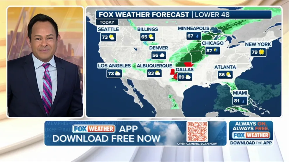
Weather in America: June 3, 2025
FOX Weather has you covered with the breaking forecasts and weather news headlines for your Weather in America on Tuesday, June 3, 2025. Get the latest from FOX Weather Meteorologist Craig Herrera.
Welcome to the Daily Weather Update from FOX Weather. It's Tuesday, June 3, 2025. Start your day with everything you need to know about today's weather. You can also get a quick briefing of national, regional and local weather whenever you like with the FOX Weather Update podcast.
Forecasters monitor Southeast coast for possible tropical development this week
Forecasters with the National Hurricane Center (NHC) are monitoring an area of disturbed weather off the southeastern coast of the U.S. for the potential for tropical development.
The FOX Forecast Center has been monitoring rain and thunderstorms moving across the Florida Peninsula, which are increasing the risk of flash flooding and bringing the threat of severe weather to the Sunshine State.
According to the NHC, the activity over Florida could also spawn areas of disturbed weather off the Southeast coast that could eventually take on tropical characteristics by the end of the week.
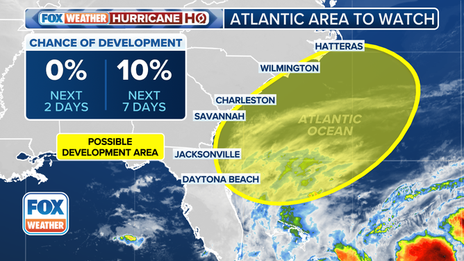
This graphic shows an area to watch for tropical development off the Southeast coast.
(FOX Weather)
Days of tropical moisture soak Florida with heavy rain, flash flooding
Before that system potentially emerges off the Southeast coast later this week, it will spend days soaking Florida, which saw heavy rain and severe storms on Monday.
On Tuesday, a Level 2 out of 4 flash flood threat is in place for South Florida, where 3-5 inches of rain is possible by the end of the week. The rain over the Sunshine State is expected to last through Friday.
![FOX35 Orlando Thundertruck drives through heavy rain.]() Image 1 of 3
Image 1 of 3FOX35 Orlando Thundertruck drives through heavy rain. (FOX35 Orlando)
![A suburban road began to flood in Tampa, Florida, on Monday, as the National Weather Service issued a Severe Thunderstorm Warning for the area.]() Image 2 of 3
Image 2 of 3A suburban road began to flood in Tampa, Florida, on Monday, as the National Weather Service issued a Severe Thunderstorm Warning for the area. (@wm1fl via Storyful)
![Lightning strikes off the coast of Naples, Florida on Monday, June 2, 2025.]() Image 3 of 3
Image 3 of 3Lightning strikes off the coast of Naples, Florida on Monday, June 2, 2025. (@pbyrond via Storyful)


Severe weather brings stormy start to June for central US
A broad area from Central Texas through the Ozarks and Michigan's Upper Peninsula is at risk of severe weather Tuesday afternoon and evening, with the most widespread storms expected in the central and southern Plains.
A cold front will move east through the day, bringing damaging wind gusts and large hail as the primary threats. Storms may even spawn a few tornadoes, particularly over parts of the central Plains.
On Wednesday, the severe weather threat will shift to the Great Lakes, but more disturbances are expected to move through the central and southern U.S., setting the stage for daily rounds of severe weather later in the week.
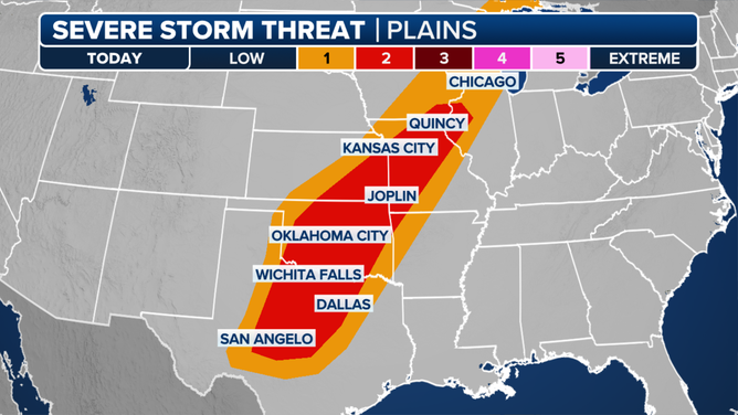
This graphic shows the severe weather threat on Tuesday, June 3, 2025.
(FOX Weather)
Watch this: Eruption at Yellowstone National Park pool caught on camera
A small eruption in Yellowstone National Park that happened over the weekend was caught on video by a newly installed webcam.
According to the U.S. Geological Survey, the eruption happened Saturday evening at Black Diamond Pool in Biscuit Basin.
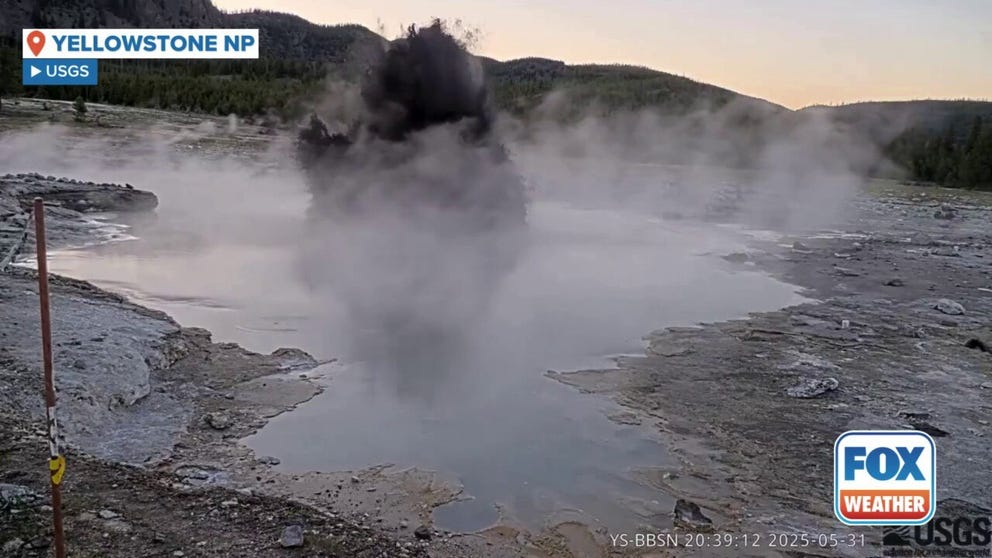
Eruption at Yellowstone National Park caught on camera
The USGS released this video of an eruption at Black Diamond Pool in Yellowstone National Park that happened May 31, 2025.
Before you go
Here are a few more stories you might find interesting.
- Magnitude 5.8 earthquake along Turkish coast leaves at least 1 dead as people jump from windows amid panic
- Tropical depression could form in Eastern Pacific this week on heels of Tropical Storm Alvin
- Smuggler with bag full of venomous viper snakes stopped by India customs
Need more weather? Check your local forecast plus 3D radar in the FOX Weather app. You can also watch FOX Weather wherever you go using the FOX Weather app, at foxweather.com/live or on your favorite streaming service.
It’s easy to share your weather photos and videos with us. Email them to weather@fox.com or add the hashtag #FOXWeather to your post on your favorite social media platform.