Crippling ice threatens millions in historic winter storm path with major power outages and travel issues
A dangerous ice storm takes shape in the South, threatening widespread power outages for millions of Americans for several days, on top of major travel concerns and other potentially catastrophic impacts.

Dangerous ice storm taking shape threatening widespread power outages and travel concerns as warnings expand
A dangerous ice storm takes shape in the South threatening widespread power outages for millions of Americans for several days and major travel concerns. Ice Storm Warnings have expanded across the region, including in Charlotte, Raleigh, Memphis, Greenville and a mass of areas in the South. FOX Weather Meteorologist analyzes the potentially catastrophic threat forecast to bring dangerous winter weather to millions in the region.
As the historic winter storm begins to take shape in the South, over 235 million Americans across 40 states will feel the impacts of the vicious storm's 2,300-mile-long winter weather footprint.
While millions will see significant snow for the first time in a decade, millions more across the South won't share the same sentiment as crippling ice threatens to paralyze areas across the vulnerable region.
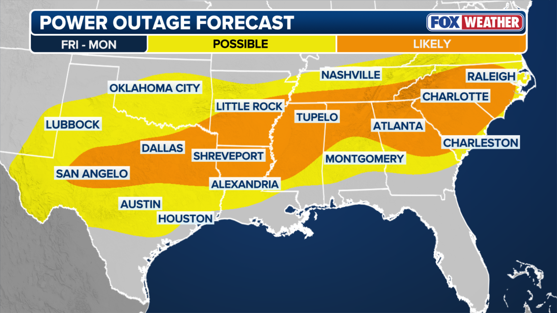
Widespread power outages, major transportation disruptions, falling trees and downed power lines are all on the cards for millions of Americans as Ice Storm Warnings have expanded across the Southeast, where impacts from a major ice storm could be catastrophic.
DRIVING WITH SNOW ON TOP OF YOUR CAR IS ILLEGAL IN SEVERAL STATES ACROSS THE US
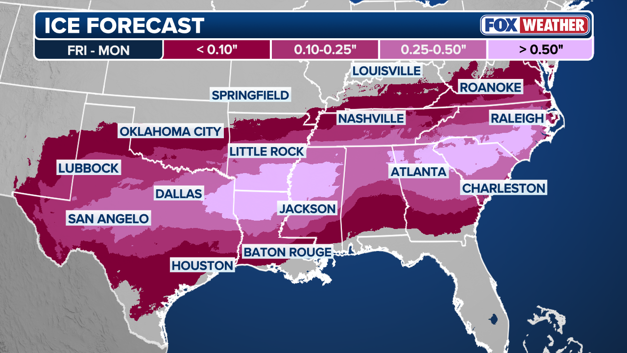
Ice Storm Warnings are in place across eight states from Arkansas to North Carolina, including parts of eastern Texas, Tennessee, northern Mississippi, Alabama and northeastern Louisiana, as a number of areas have already issued states of emergency along the wide swath of 40 states forecast to get slammed by winter weather this weekend.
(FOX Weather)
More than 15 states, from Nevada to Pennsylvania, are forecast to see different levels of ice accretion from the vicious winter storm, with a particularly vulnerable corridor including Little Rock, Arkansas, Oxford, Mississippi and Memphis, Tennessee, where up to 0.75 inches of ice is possible, on top of an even more daunting potential of over an inch (1") of ice in some localized areas.
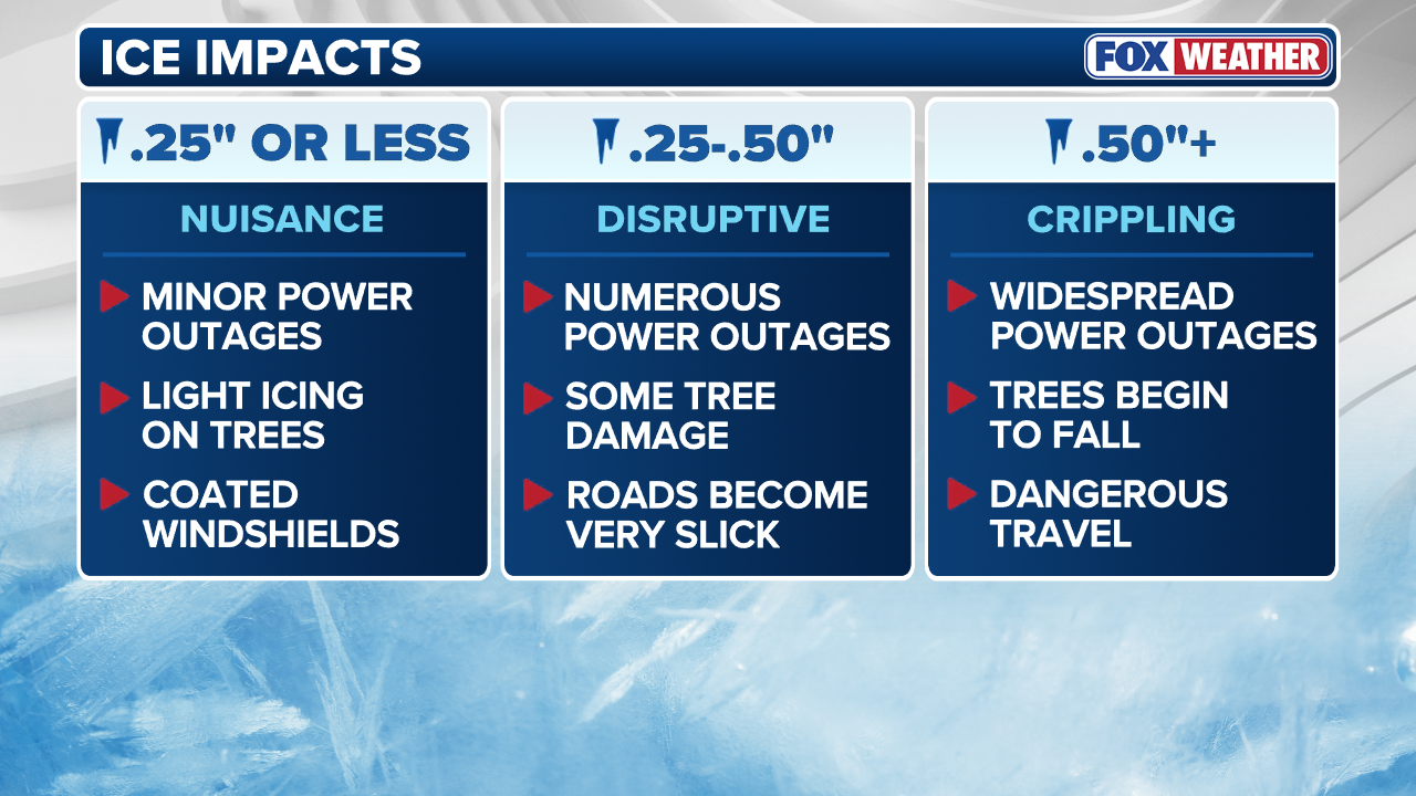
HOW MUCH ICE IS NEEDED TO KNOCK OUT POWER, DAMAGE TREES?
"A lot of our reliable forecast modeling has some places where ice totals exceed an inch. You have numbers like that: trees are coming down, power lines are coming down, traveling on the roads is impossible, and those power outages will be extended as it will be a huge clean-up, plus, for an extended period of time. It will be challenging for crews to get to some of these areas where the outages occur," FOX Weather Meteorologist Ian Oliver said. "So plan for that, plan for several days without power if you're included in this whole swath."

(FOX Weather)
In the Plains, the highest ice accretions of 0.50 inches or more will exist from far eastern Texas through southern Arkansas by Sunday afternoon as widespread power outages will become increasingly likely in these areas.
Locations from west Texas through Dallas could see around 0.25 to 0.50 inches of ice, which would be sufficient to cause numerous power outages and severely disrupt travel along major interstates such as I-20 and I-35 into Sunday.
(FOX Weather)
Within the affected regions, ice accumulation is expected to cause crippling impacts on both power infrastructure and travel.
HOW TO WATCH FOX WEATHER ON ANY DEVICE FOR FREE
Widespread power outages are likely as the weight of the ice compromises lines and topples trees. Travel will become extremely hazardous, particularly on major interstates such as I-20, I-40, and I-95, where significant icing will lead to dangerous or near-impossible driving conditions.
Ice Storm Warnings now stretch across eight states from Arkansas to North Carolina.
(FOX Weather)
Crippling ice is considered 0.50 inches of ice accretion, which has a vicious slew of devastating consequences, including widespread power outages, downed trees and extremely dangerous travel conditions.
With the possibility of 1 inch of ice accretion in the forecast, the impacts are cataclysmic, and could effectively paralyze affected areas for days on end.
HOW TO STAY SAFE FROM DANGEROUS WINTER ICE
The threat of ice continues into the Mid-Atlantic and the Northeast as major cities and local areas could see the same crippling ice totals as the storm tracks north.
Cities including Richmond, Washington D.C. and Baltimore could all see 0.50 inches of ice accretion, on top of potentially record snowfall totals this decade.
Though New York City, Philadelphia and Boston will have their hands full, as recent forecasts suggest more than a foot of snow, but ice accretion will be a much lesser concern if at all.
(FOX Weather)
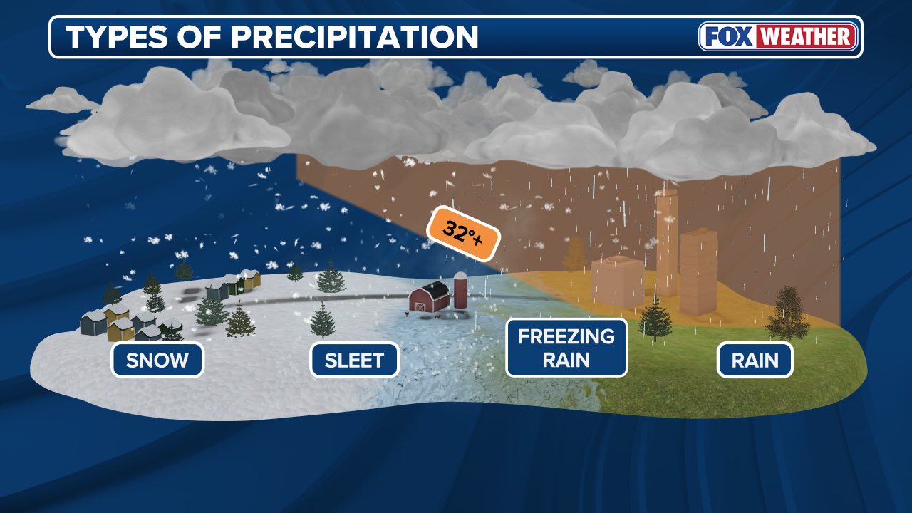
The recipe for an ice storm depends on a number of factors and can be devastating when forecasts align as they have in this historic winter storm currently unfolding.
Ice accretion occurs as a result of freezing rain, which forms when snow falls through a layer of air in the atmosphere with a temperature higher than 32 degrees, melting the snowflakes into raindrops.
WHAT FACTORS GO INTO A SNOW DAY FOR SCHOOL DISTRICTS?
The rain then moves into a shallow layer of subfreezing air near the ground, causing the precipitation to freeze on contact with roads, sidewalks, trees, power lines, cars and other objects, which can be extremely dangerous when totals begin to add up.

FILE: This photo from a historic ice storm in North Carolina in December, 2002 provides a brief glimpse into the catastrophic impacts of an ice storm.
(National Weather Service in Raleigh / FOX Weather)
The catastrophic results of a dangerous ice storm were on display in North Carolina in December 2002, when more than one million across the state lost power. It took nine days before electrical services were completely restored across the state, with damage assessments totaling more than $110 million statewide, according to a report from North Carolina State University.
With this major winter storm packing all the necessary ingredients for a damaging ice storm, what results could cripple power, cause massive travel delays and bring potentially catastrophic impacts to the affected region.
TIMELINE: WHEN THE POTENTIALLY HISTORIC WINTER STORM IS EXPECTED TO SWEEP ACROSS THE US THIS WEEKEND
With temperatures forecast to remain frigid in the South into next week, leading to prolonged impacts for areas affected by ice and snow. This persistent deep freeze in the Southeast will cause any daytime melting to refreeze, creating hazardous 'black ice' and further complicating power restoration and recovery efforts across.