Round of severe storms expected to slam millions early this week across 1,000+ miles with damaging hail, winds
Right now, a Level 2 out of 5 severe storm threat has been issued for parts of the region for Monday, Tuesday and Wednesday.

1,000-mile storm system to continue multi-day severe weather threat, millions at risk of damaging winds, hail, tornadoes
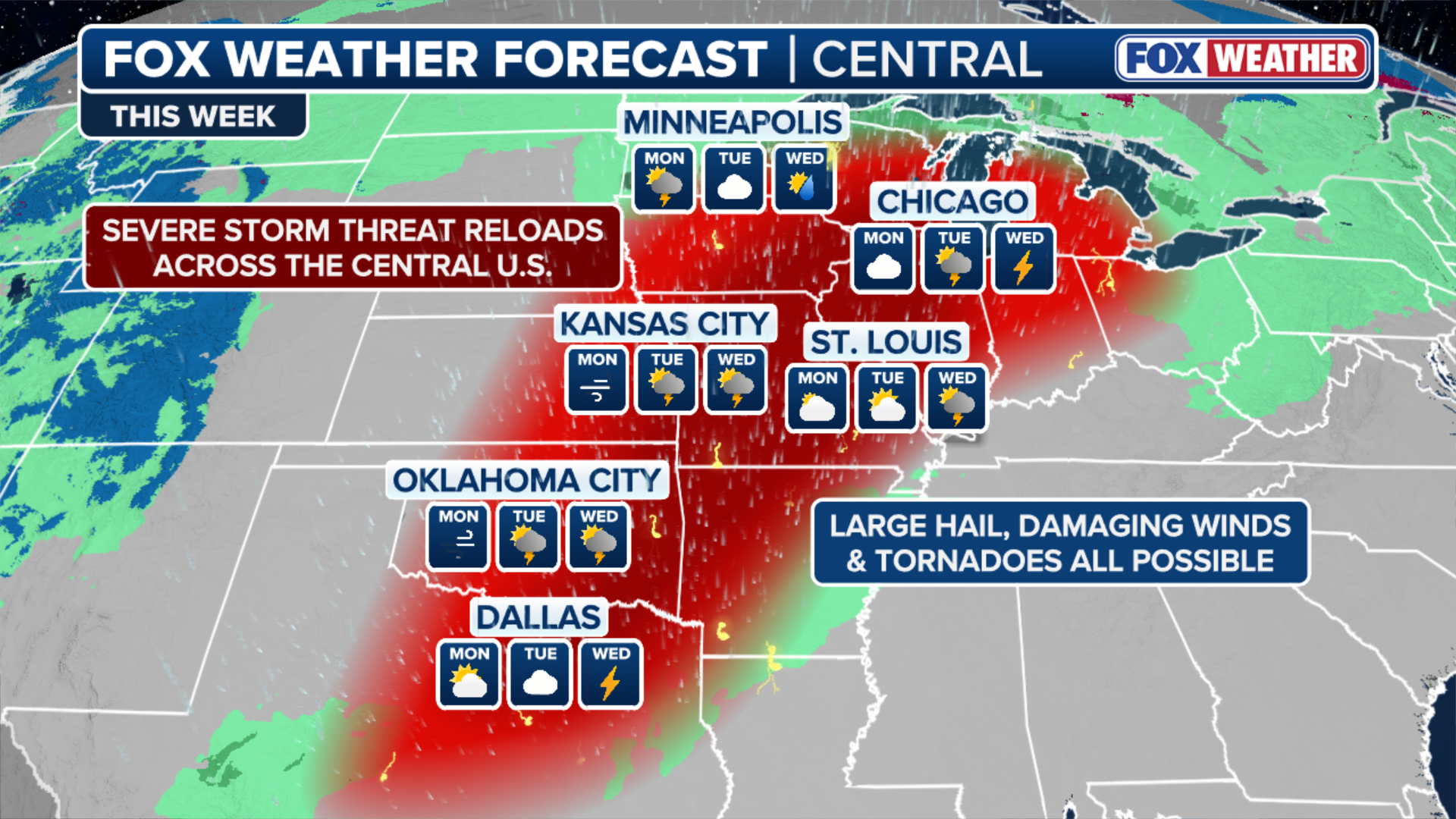
A more widespread and significant severe weather stretch is brewing for early to midweek. This 1,000+ mile system is set to impact millions with risks of large hail, damaging winds, and tornadoes, continuing the multi-day storm threat across the Plains and Midwest. Latest:
While severe storms impact the Plains this weekend, a far more significant and widespread threat is brewing for early through midweek, affecting millions as part of a multi-day severe storm threat.

(FOX Weather)
This second wave will span over 1,000 miles, covering over a dozen states in its path, bringing expanding and heightened risks of large hail, damaging winds and tornadoes, from the Midwest to the Southern Plains.
THIS IS WHAT YOU SHOULD DO IF YOU ARE DRIVING AND THERE IS A TORNADO ON THE GROUND
Right now, a Level 2 out of 5 severe storm threat has been issued for parts of the region for Monday, Tuesday and Wednesday.
(FOX Weather)
Following the weekend's activity, another potent storm will track out of the West and into the Plains by Monday. This system will broaden the risk area to span from the Southern Plains to the Upper Midwest.
Ahead of this system, warm, moist air from the Gulf and significant atmospheric energy will surge north, allowing severe storms to break out in two distinct locations.
LIFE-THREATENING TORNADO RIPS THROUGH PARTS OF ILLINOIS AS SEVERE WEATHER LASHES THE HEARTLAND
The first location will target portions of the Upper Midwest, where a Level 2 out of 5 severe storm threat covers Minneapolis, Milwaukee and Madison.
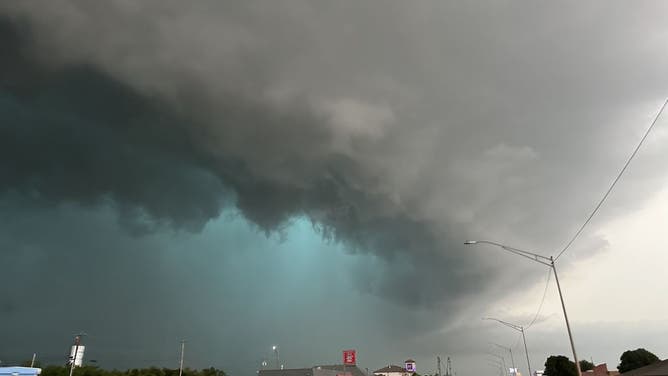
![Brandon Copic shot of a tornado in Illinois on March 10, 2026.]() Image 1 of 6
Image 1 of 6Brandon Copic shot of a tornado in Illinois on March 10, 2026. (FOX Weather)
![FILE - CHICAGO, IL - JUNE 12: Lightning strike above downtown on June 12, 2013 in Chicago, Illinois.]() Image 2 of 6
Image 2 of 6FILE - CHICAGO, IL - JUNE 12: Lightning strike above downtown on June 12, 2013, in Chicago, Illinois. ((Photo by Scott Olson/Getty Images))
![Photos from the ground in Aroma Park, Illinois, on March 12 capture the devastating destruction in Kankakee County after a tornado ripped through March 10]() Image 3 of 6
Image 3 of 6Photos from the ground in Aroma Park, Illinois, on March 12 capture the devastating destruction in Kankakee County after a tornado ripped through March 10 (FOX Weather Correspondent Katie Byrne )
![Storm damage in Kinmundy, IL, March 7]() Image 4 of 6
Image 4 of 6Storm damage in Kinmundy, IL, March 7 (Salem/Marion COunty EMA)
![Devastating tornado caught on camera in Union City, Michigan]() Image 5 of 6
Image 5 of 6Devastating tornado caught on camera in Union City, Michigan (Lisa Nicola)
![FILE - HENNESSEY, OKLAHOMA - MAY 07: A view of mesocyclone and green glow from very large hail as a tornadic high precipitation supercell arrives in Hennessey, Oklahoma, United States on May 07, 2024. (Photo by Matt Phelps, Tempest Tours/Anadolu via Getty Images]() Image 6 of 6
Image 6 of 6FILE - HENNESSEY, OKLAHOMA - MAY 07: A view of mesocyclone and green glow from very large hail as a tornadic high precipitation supercell arrives in Hennessey, Oklahoma, United States on May 07, 2024. (Photo by Matt Phelps, Tempest Tours/Anadolu via Getty Images) (Photo by Matt Phelps, Tempest Tours/Anadolu via Getty Images)


That's where a cluster of storms may develop in the afternoon and race east, bringing the potential for elevated severe cells with damaging wind gusts and large hail.
The second location, further south, also holds another Level 2 out of 5 severe storm threat across portions of the Texas panhandle and central Oklahoma, where storms are expected to develop along the dryline.
Although activity could be suppressed early on in the day, intense daytime heating and an abundance of moisture should allow the cap to give way, leading to supercell development.
"If these storms mature, all severe threats will be possible, including a couple of tornadoes," the FOX Forecast Center said.

(FOX Weather)
On Tuesday, a new area of low pressure will move in, situating itself across the Central Plains toward the Great Lakes.
Strong wind shear and abundant moisture will fuel additional severe storms, with a greater risk shifting even farther south from the lower Missouri Valley into the southern Plains and possibly the Louisiana Gulf Coast.
By Tuesday afternoon and into the evening, the setup could bring an even greater risk of severe weather to a broader population, including threats of hail, damaging winds and tornadoes.
High wind shear and instability will support additional severe development, with a Level 2 out of 5 severe threat currently stretching from southern Michigan through Iowa and south into the Southern Plains.

Large hail in Shawnee, Kansas
(Veronika Whitaker Ray / FOX Weather)
The FOX Forecast Center highlights that a more significant severe weather event could unfold Tuesday afternoon into the evening, with all severe threats likely.
With the latest forecasts suggesting the greatest potential for these risks may shift further north into the warm sector of the Midwest, cities such as Chicago, Milwaukee, St. Louis, Detroit and Kansas City could all be impacted.

(FOX Weather)
Finally, by Wednesday, a cold front will slice through the Upper Midwest south into the Mississippi Valley.
MUCH-NEEDED RAIN PERSISTS ACROSS DROUGHT-STRICKEN FLORIDA AS COASTAL FLOOD THREAT BUILDS
A Level 2 out of 5 severe weather threat exists near Indianapolis, from south through St. Louis, Oklahoma City and Dallas.
Although some uncertainty remains regarding exactly where storms will start, the atmosphere is expected to remain unstable, potentially leaving room to fuel storms.