Blizzard Warnings posted as high-impact snowstorm takes aim at the northern Plains, Upper Midwest
Like with previous storm systems that have taken similar tracks across the U.S. over the past several weeks, there is a significant risk of dangerous severe weather that could sweep across portions of the central U.S. starting on Tuesday.
High-impact winter storm may deliver feet of snow to northern Plains
A powerful blizzard will bring the potential for heavy snowfall to the Dakotas this week. Gusty winds are expected with the snowstorm.
The FOX Forecast Center is tracking a powerful coast-to-coast storm that could bring blizzard conditions to millions of people living in the Plains and Upper Midwest this week and could significantly impact travel before life-threatening wind chills move into the region.
And like with previous storm systems that have taken similar tracks across the U.S. over the past several weeks, there is a significant risk of dangerous severe weather that could sweep across portions of the central U.S. starting on Tuesday.
WHAT MAKES A BLIZZARD DIFFERENT FROM AN ORDINARY SNOWSTORM?
Where is the winter storm now?

(FOX Weather)
HERE'S WHAT TO KEEP IN YOUR CAR IN CASE YOU GET STUCK
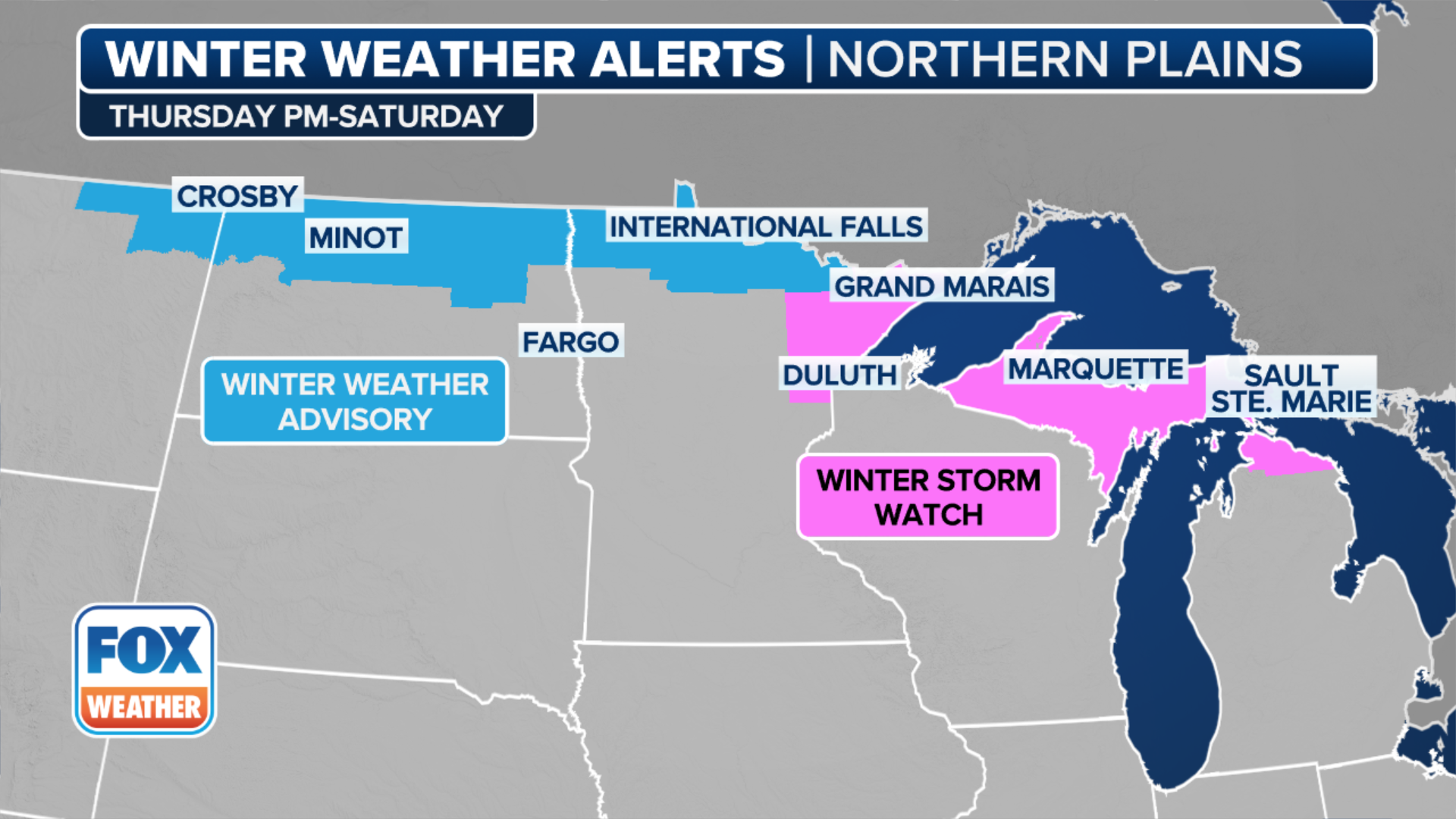
The National Weather Service has issued various winter weather alerts that will be in effect through at least Thursday morning from the Rockies to the Great Lakes. Blizzard Warnings are in effect for the Dakotas and part of Minnesota and Nebraska.
DRIVING ON ICE AND DRIVING IN THE SNOW
(FOX Weather)
Winter weather alerts also stretch into the Plains and Upper Midwest, where the National Weather Service warned that this could become the "biggest snowstorm of the year" for parts of the northern Plains.
'This is a spring storm on steroids': Blizzard approaches Plains, Upper Midwest
FOX Weather Winter Storm Specialist Tom Niziol said a blizzard would produce massive amounts of snow and strong winds in the Plains and parts of the Upper Midwest.
HERE'S WHY ‘BLIZZARD ALLEY’ IS IN THE NORTHERN PLAINS
Cities under the Blizzard Warnings include Grand Forks, Fargo and Bismarck in North Dakota, and Pierre, Rapid City and Sisseton in South Dakota.
Winter Storm Watches are in effect for portions of South Dakota and northern Minnesota.
What is the timing of the winter storm?
Tuesday

(FOX weather)
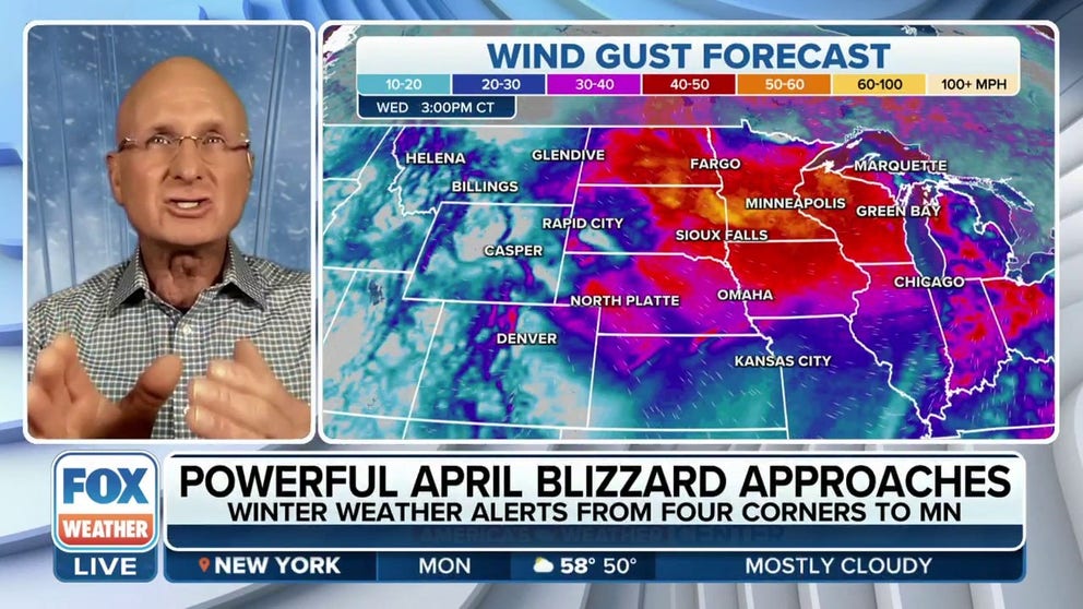
By Tuesday, the strengthening storm system over the central Plains is expected to produce periods of heavy snow and high winds across the northern Plains and Upper Midwest.
Blizzard conditions are likely from parts of southwestern Wyoming to eastern North Dakota and northern Minnesota, including much of South Dakota and northwestern Nebraska.
More than a foot of snow combined with the strong winds leading to blowing and drifting snow is likely to lead to dangerous and nearly impossible travel conditions in those areas and a disruption to daily life, according to the NWS.
In addition, wind chills are expected to be near to below zero during the blizzard conditions and could be life-threatening to anyone caught outdoors.
There could also be a significant risk to livestock, so farmers across the region will need to take precautions to protect the lives of their animals.
Wednesday

(FOX Weather)
The storm is expected to be centered over the Upper Midwest by Wednesday, and winter weather conditions are expected to continue across the region.
How much snow is expected?
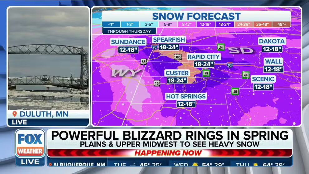
The FOX Forecast Center expects 1 to 2 feet of wind-driven snow across the Dakotas, as well as portions of extreme northwestern Minnesota and northwestern Nebraska.
Amounts higher than 2 feet are also possible in portions of South Dakota, including the Rapid City area, as the storm continues to strengthen and sweep across the northern Plains.

(FOX Weather)
Minneapolis, which the NWS-Twin Cities says is currently experiencing its third-snowiest winter on record, will only need another 5.4 inches to move into second place.
However, it doesn’t seem too likely that the Twin Cities metro area will see an additional 5.4 inches of snow during this storm because it’s expected to remain mostly rain with a brief mix of sleet or freezing rain possible on Tuesday.