Tropical disturbance moving off Africa being monitored for possible development
After the tropical wave emerges off the African coast, the NHC said environmental conditions could support some slow development of the system over the next week.

Area to watch off the coast of Africa
FOX Weather Meteorologist Jane Minar breaks down the latest updates for the tropics, as activity may increase in the basin starting in mid-September.
MIAMI – The National Hurricane Center (NHC) is continuing to monitor a tropical wave emerging into the eastern Atlantic Ocean off the coast of Africa for possible tropical development over the next week.
The heightened activity comes as we near the peak of the 2025 Atlantic hurricane season, which runs from June 1 through Nov. 30.
![]() Image 1 of 8
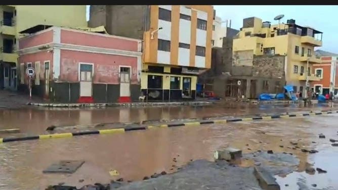
Image 1 of 8Flooding damage on the island of São Vicente, Cape Verde on Aug. 11, 2025. (Angelo Barbosa/Facebook )
![Flooding damage on the island of São Vicente, Cape Verde on Aug. 11, 2025.]() Image 2 of 8
Image 2 of 8Flooding damage on the island of São Vicente, Cape Verde on Aug. 11, 2025. (Angelo Barbosa/Facebook )
![Flooding damage on the island of São Vicente, Cape Verde on Aug. 11, 2025.]() Image 3 of 8
Image 3 of 8Flooding damage on the island of São Vicente, Cape Verde on Aug. 11, 2025. (Angelo Barbosa/Facebook )
![Flooding damage on the island of São Vicente, Cape Verde on Aug. 11, 2025.]() Image 4 of 8
Image 4 of 8Flooding damage on the island of São Vicente, Cape Verde on Aug. 11, 2025. (Angelo Barbosa/Facebook )
![Flooding damage on the island of São Vicente, Cape Verde on Aug. 11, 2025.]() Image 5 of 8
Image 5 of 8Flooding damage on the island of São Vicente, Cape Verde on Aug. 11, 2025. (Angelo Barbosa/Facebook )
![Flooding damage on the island of São Vicente, Cape Verde on Aug. 11, 2025.]() Image 6 of 8
Image 6 of 8Flooding damage on the island of São Vicente, Cape Verde on Aug. 11, 2025. (Angelo Barbosa/Facebook )
![Flooding damage on the island of São Vicente, Cape Verde on Aug. 11, 2025.]() Image 7 of 8
Image 7 of 8Flooding damage on the island of São Vicente, Cape Verde on Aug. 11, 2025. (Angelo Barbosa/Facebook )
![Flooding damage on the island of São Vicente, Cape Verde on Aug. 11, 2025.]() Image 8 of 8
Image 8 of 8Flooding damage on the island of São Vicente, Cape Verde on Aug. 11, 2025. (Angelo Barbosa/Facebook )


The NHC said that a tropical wave is expected to emerge off the western coast of Africa by Monday to the south of the Cabo Verde Islands, which were hit hard by a tropical system, known as Invest 97L, that eventually became Hurricane Erin.
Hurricane Erin rapidly intensified into a monster Category 5 hurricane with winds of 160 mph as it spun across the Atlantic.
DOWNLOAD THE FREE FOX WEATHER APP

(FOX Weather)
After the tropical wave emerges off the African coast, the NHC said environmental conditions could support some slow development of the system while it moves off to the west or west-northwest at around 15 mph across the eastern and central tropical Atlantic basin this week.
Right now, the NHC is giving the system a medium chance of development over the next week.