Bryan Norcross: Tropical Disturbance 97L is likely to be named Erin this week
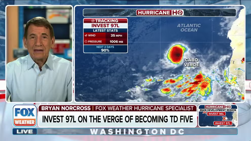
The increasingly organized tropical disturbance just past the Cabo Verde Islands in the far eastern Atlantic is on the verge of becoming a tropical depression. The National Hurricane Center's forecast is that the disturbance will develop into a depression or Tropical Storm Erin shortly. The computer forecasts uniformly agree.
Tracking Invest 97L, likely to become Tropical Storm Erin
FOX Weather Hurricane Specialist Bryan Norcross joined FOX Weather Command and analyzes Invest 97L which is expected to become Tropical Storm Erin in the Atlantic Basin and head west. While there is nothing actionable now, people from Florida to Canada should be aware.
Updated at 9:45 a.m. ET on Aug. 11, 2025.
On average, the first hurricane of the season develops on this date – August 11. Obviously, we don't have one yet, but the long-range prediction is that the weather pattern will be supportive of a hurricane in the Atlantic in less than a week.
The increasingly organized tropical disturbance just past the Cabo Verde Islands in the far eastern Atlantic is on the verge of becoming a tropical depression. The National Hurricane Center's forecast is that the disturbance will develop into a depression or Tropical Storm Erin shortly. The computer forecasts uniformly agree.
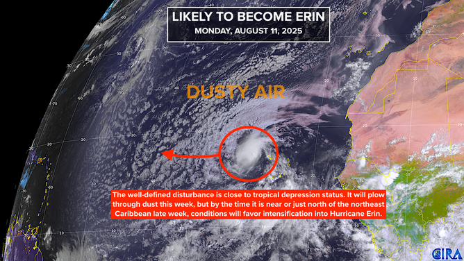
The NHC has shrunk the potential development area thinking the system will organize very soon. They have the odds of development in the high category. But we’ll see if the dust has other ideas. In any case, the system should outrun the dust as it gets closer to the northeast Caribbean later this week.
This satellite image shows Invest 97L in the tropical Atlantic basin.
(FOX Weather)
Wherever and whenever it strengthens, it's very likely to be named Erin – maybe Hurricane Erin – when it is near Puerto Rico and the nearby islands or over the waters just to the north about Saturday.
The steering pattern in the short term is straightforward. High pressure to the north will force the system almost due west. Toward the end of the week, when the depression or Erin is nearing the northeast Caribbean islands, however, the pattern to the north becomes more complex.
A cold front will push off the Northeast coast of the U.S., which will force the blocking high to the east and open a corridor north to one degree or the other. It's the degree that's the open question. These days, computer models produce a range of plausible scenarios that are designed to reflect the intrinsic uncertainty in long-range forecasts.
In addition, the intensity of the storm at any point along the track will affect its angle of movement. If likely-Erin stays weaker longer, it's more likely to be pushed west by the prevailing trade-wind flow. If it gets strong sooner, the dip in the jet stream associated with the front is more likely to pull it north.
The consensus of the various computer forecasts, which in theory take all this into account, track the developing hurricane north of the Caribbean, turning it north well offshore of the East Coast. Bermuda could be threatened in that scenario.
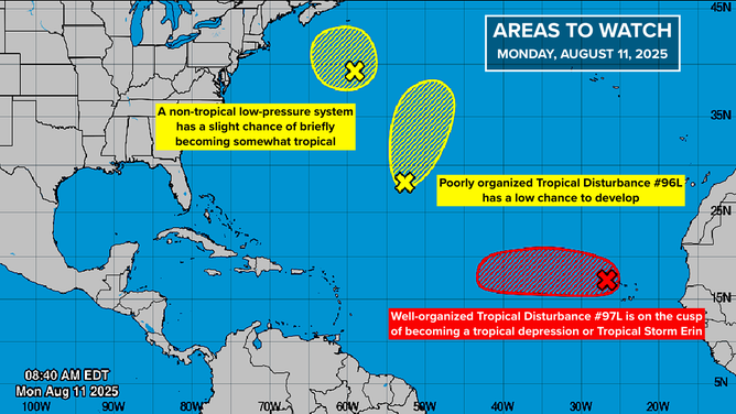
This image shows activity and development chances in the tropical Atlantic basin.
(FOX Weather)
We have all seen how the long-range forecasts for this storm have jumped around, however. So with these long-range forecasts, the consensus is not the best approach. We have to look at the variety of plausible scenarios so that nobody takes down their guard too early.
Because we're looking so far in the future, the possible impact area is still very wide - from the Southeast U.S. to Atlantic Canada. As the system organizes, and the computer forecast models have a better starting point from which to make predictions, the potential impact zone will narrow.
At the very least, significant beach impacts from strong swells are likely from Erin as it moves parallel to the East Coast next week. But how close does the storm itself come?
For now, we have to be a little patient. We look at computer projections for a week or more in the future because we can, not because we get any actionable information from them. The good thing is, the system is some 2,500 miles from Puerto Rico and 3,500 miles from Florida, so nothing is going to happen right away.
Other low-chance systems
The disorganized disturbance the National Hurricane Center tagged Invest #96L is struggling. It still has a low chance to develop, but even if it does, it won't impact land.
Now, another low-chance system is on the board. It’s a non-tropical low-pressure system offshore of New England, but is over the warm Gulf Stream. It has a slight chance of taking on some tropical characteristics before it moves over the cold North Atlantic waters.
Still to come
More disturbances are forecast to move off Africa behind 97L, though the long-range computer forecasts don't show any of them developing quickly.