Tropical Storm Erin expected to become a hurricane Friday as Tropical Storm Watches in effect for Caribbean
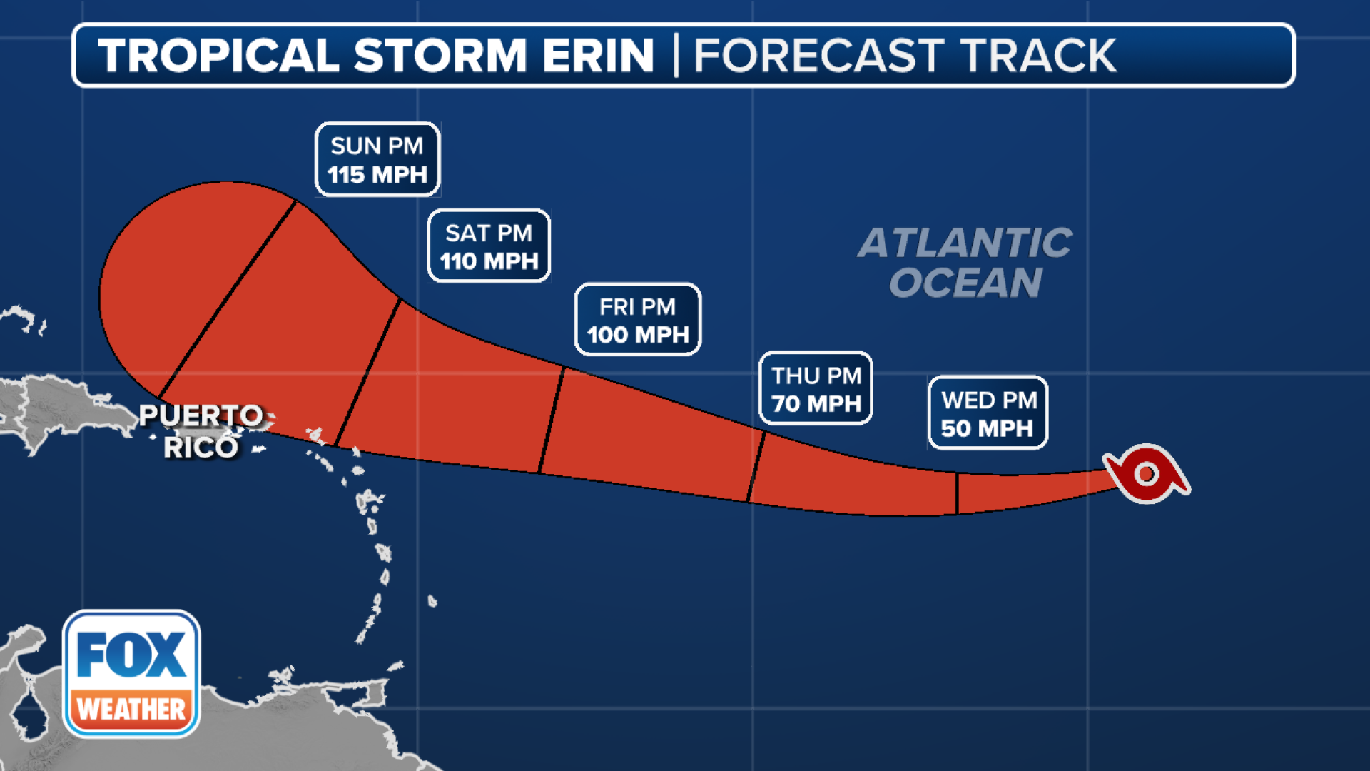
The National Hurricane Center (NHC) believes that Erin could reach major hurricane status (Cat 3+) this weekend and is forecast to become a Category 4 hurricane with peak wind speeds of around 130 mph.

Tropical Storm Erin expected to become a hurricane later Friday
Tropical Storm Erin is on the cusp of strengthening into a hurricane, which it is expected to become later this Friday, as it bears down on the northern Caribbean islands. FOX Weather Meteorologists Craig Herrera and Michael Estime have the latest on Erin's track and potential impacts.
Update as of Friday at 11:00 AM ET: Erin strengthened into the Atlantic's first hurricane of 2025. Continuous coverage of Hurricane Erin has moved here.
MIAMI – Tropical Storm Erin is on the cusp of strengthening into a hurricane, which it is expected to become later this Friday, as it bears down on the northern Caribbean islands.
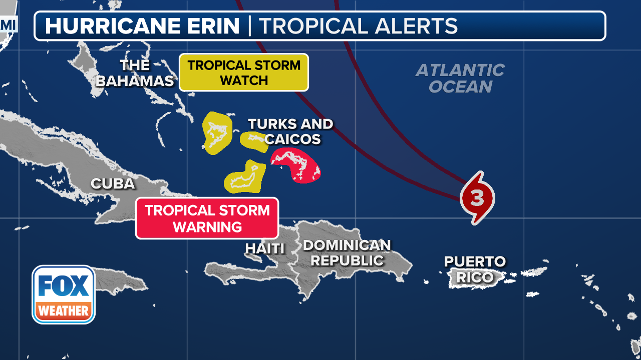
Tropical Storm Watches are in effect for Anguilla, Barbuda, St. Barthelemy, St. Martin, Saba and St. Eustatius, which means tropical storm conditions are possible during the next 48 hours.
According to the National Hurricane Center (NHC), Erin did struggle somewhat to become better organized early Friday morning but is in a favorable environment for strengthening.
The NHC believes that Erin could reach major hurricane status (Cat 3+) this weekend and is forecast to become a Category 4 hurricane with peak wind speeds of around 130 mph.
Erin's center is expected to move near or just north of the northern Leeward Islands over the weekend, according to the NHC.
There is still some uncertainty regarding Erin's exact impact on the East Coast of the U.S., the Bahamas and Bermuda, the Hurricane Center said in its Friday morning discussion.
(FOX Weather)
While at this point it doesn’t appear as though the Leeward Islands, the Virgin Islands or Puerto Rico will take a direct hit from soon-to-be Hurricane Erin, preparations for potential impacts are underway nonetheless.
Officials in the U.S. Virgin Islands said territory-wide sandbag distribution for hurricane season was set to begin in a matter of days, but with Tropical Storm Erin spinning across the Atlantic, those plans were accelerated.
"Due to the projected impact of Tropical Storm Erin on the U.S. Virgin Islands, the Virgin Islands Territorial Emergency Management Agency (VITEMA), in partnership with the Virgin Islands Fire and Emergency Services, the Department of Public Works, the Office of ADA Coordinator, and the Department of Human Services, has accelerated the territory-wide sandbag distribution program," officials said in a Facebook post.

US Virgin Islands preparing for possible impacts from Tropical Storm Erin
While the U.S. Virgin Islands aren’t expected to take a direct hit, preparations are still being done in case impacts are felt across the U.S. territory. Director of the Virgin Islands Territorial Emergency Management Agency (VITEMA) Daryl D. Jaschen joined FOX Weather on Thursday to talk about how they’re preparing.
Officials said this accelerated distribution represents the only sandbag distribution for the 2025 hurricane season.
"We strongly encourage all residents to take advantage of this opportunity to protect their homes and property," officials said.
Daryl Jaschen, the Director of the Virgin Islands Territoral Emergency Management Agency (VITEMA), joined FOX Weather on Thursday and talked about his concerns and how the island territory is preparing.
"It’s very important that our community get the opportunity to get sandbags primarily for that wind-driven rain," he said. "So, my concern is wind-driven rain, the marine conditions, and of course the wind overall."
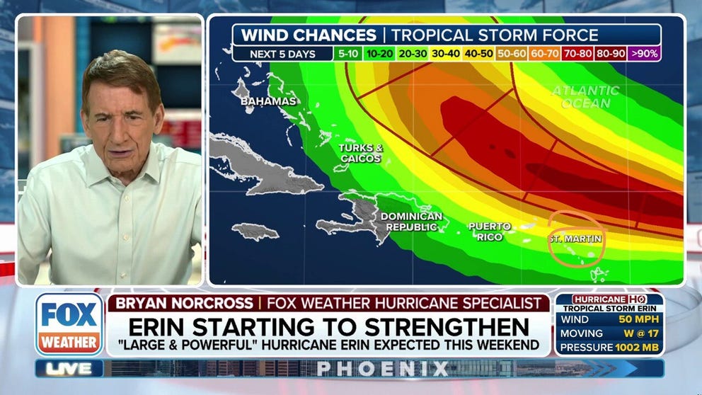
Bryan Norcross offers expert analysis on ‘pristine atmosphere’ for rapid intensification of Tropical Storm Erin
FOX weather Hurricane Specialist Bryan Norcross offers expert analysis of the latest forecast for Tropical Storm Erin, which is expected to become a hurricane by tomorrow and then rapidly intensify into a major hurricane this weekend.
And preparing isn't as easy as it is for Americans on the mainland.
"About 98 percent of our goods come from outside the territory," he continued. "So, my power plants, I have to get fuel for them. I have to get support for the airports. I have communications. We just started school yesterday, so, obviously, the impact for schools and the parents."
And while residents have been busy getting ready for potential impacts from Tropical Storm Erin, tourists also need to be informed.
"We do have a Department of Tourism," Jaschen said. "We have the ability to mass communicate for the Department of Tourism, as well as our hotel association to encourage (tourists) to basically start making their moves."
If a State of Emergency is declared, work will begin to try and get tourists to safety, "especially from St. John over to St. Thomas."

Bahamas touristry board preparing for brush with Erin
The Bahamas' government is preparing for possible impacts from a brush with Erin this weekend. Hon. Leon E. Lundy, minister of state with Responsibility for Disaster Risk Management, talks about the preparation for the country's tourism industry as well as how their residents are preparing.
Impacts to travel have already occurred, with Royal Caribbean changing an itinerary because of the soon-to-be hurricane.
"We are closely monitoring the progression of Tropical Storm Erin and have made an itinerary change," a Royal Caribbean Group spokesperson told FOX Weather. "We communicated the change to our guests directly."
![Flooding damage on the island of São Vicente, Cape Verde on Aug. 11, 2025.]() Image 1 of 8
Image 1 of 8Flooding damage on the island of São Vicente, Cape Verde on Aug. 11, 2025. (Angelo Barbosa/Facebook )
![]() Image 2 of 8
Image 2 of 8Flooding damage on the island of São Vicente, Cape Verde on Aug. 11, 2025. (Angelo Barbosa/Facebook )
![Flooding damage on the island of São Vicente, Cape Verde on Aug. 11, 2025.]() Image 3 of 8
Image 3 of 8Flooding damage on the island of São Vicente, Cape Verde on Aug. 11, 2025. (Angelo Barbosa/Facebook )
![Flooding damage on the island of São Vicente, Cape Verde on Aug. 11, 2025.]() Image 4 of 8
Image 4 of 8Flooding damage on the island of São Vicente, Cape Verde on Aug. 11, 2025. (Angelo Barbosa/Facebook )
![Flooding damage on the island of São Vicente, Cape Verde on Aug. 11, 2025.]() Image 5 of 8
Image 5 of 8Flooding damage on the island of São Vicente, Cape Verde on Aug. 11, 2025. (Angelo Barbosa/Facebook )
![Flooding damage on the island of São Vicente, Cape Verde on Aug. 11, 2025.]() Image 6 of 8
Image 6 of 8Flooding damage on the island of São Vicente, Cape Verde on Aug. 11, 2025. (Angelo Barbosa/Facebook )
![Flooding damage on the island of São Vicente, Cape Verde on Aug. 11, 2025.]() Image 7 of 8
Image 7 of 8Flooding damage on the island of São Vicente, Cape Verde on Aug. 11, 2025. (Angelo Barbosa/Facebook )
![Flooding damage on the island of São Vicente, Cape Verde on Aug. 11, 2025.]() Image 8 of 8
Image 8 of 8Flooding damage on the island of São Vicente, Cape Verde on Aug. 11, 2025. (Angelo Barbosa/Facebook )

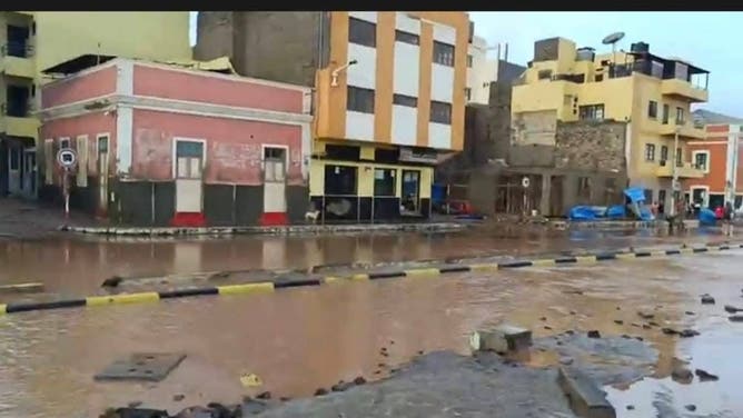


Tropical Storm Erin has already impacted other areas, including in the Cabo Verde Islands off the coast of Africa, where several people, including children, were killed when the system was known at Invest 97L.
DOWNLOAD THE FREE FOX WEATHER APP
Latest Tropical Storm Erin forecast

(FOX Weather)
The National Hurricane Center (NHC) said winds within Tropical Storm Erin have reached 70 mph with some higher gusts, and strengthening is forecast to continue over the next day or so, with more significant intensification possible on Friday and Saturday.
Erin is expected to become a hurricane by Friday, and is forecast to become a major hurricane (Category 3 or higher) over the weekend.
"The environment around Erin should remain conducive during the next day or so, which will likely promote gradual strengthening," the NHC said. "Thereafter, the storm is forecast to move across warmer waters, with potentially a decrease in shear. This evolution results in a period of potential rapid intensification late this week."
According to the NHC, rapid intensification occurs when a tropical cyclone’s maximum sustained winds increase by at least 35 mph in a 24-hour period.
Tropical Storm Erin is currently located less than 700 miles to the east of the northern Leeward Islands and is moving off to the west-northwest at 17 mph.
(FOX Weather)
On that forecast track, the center of Tropical Storm Erin is likely to move just north of the northern Leeward Islands over the weekend.
"Locally heavy rainfall, high surf and rip currents, and tropical-storm-force winds could occur over portions of the northern Leeward Islands, the Virgin Islands and Puerto Rico into this weekend as the core of Erin passes north of those islands," the NHC said.