Invest 98L likely to become tropical depression and drench Florida, Southeast with coastal flooding
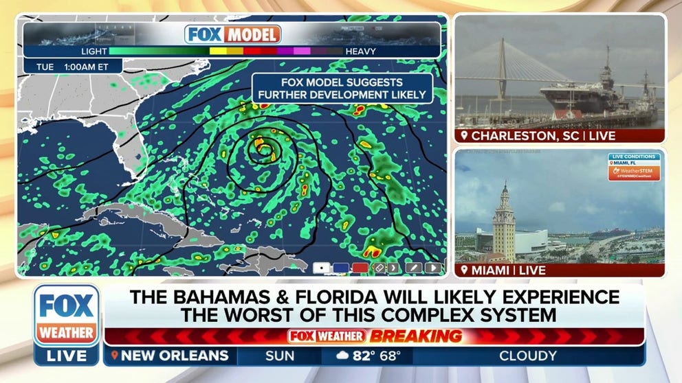
The FOX Forecast Center expects the Bahamas and Florida will likely experience the worst conditions from the storm system.
Tropical disturbance has 90% chance of developing into tropical depression, storm
The NHC identified the tropical disturbance as Invest 98L. FOX Weather shows the possible impacts.
NOTE: Invest 98L became Subtropical Storm Nicole on Monday. Click here for the latest updates from FOX Weather about Subtropical Storm Nicole. This story is no longer being updated.
The National Hurricane Center labeled the tropical disturbance in the Caribbean Sea 98L and scheduled Hurricane Hunter aircraft to investigate. The agency gave the disturbance 80% chance to develop into a Tropical Depression or Tropical Storm over the next 2 days. That system will bring strong winds, rain and coastal flooding to Florida, Georgia and the Carolinas.
Invest is a naming convention used by the NHC to identify areas meteorologists are investigating for development into a tropical depression or storm in the next 5 days. FOX Weather has the area marked as tropical disturbance #1.
The NHC said it could issue Tropical Storm, Hurricane and Storm Surge Watches for parts of the Bahamas and Florida Coast by early Monday. Florida Governor Ron DeSantis warned Floridians to be prepared for coastal flooding, winds and rain as early as Tuesday in a Tweet.
WHAT IS AN INVEST DURING HURRICANE SEASON?
The combination of an onshore flow and a dome high pressure to the system's north will mean easterly to northeasterly winds will drive a substantial amount of water towards coastal communities, which will lead to prolonged flooding, especially during periods of high tides.
In addition to the higher seas, the FOX Forecast Center warns heavy rainfall, rough surf, gusty winds and beach erosion will accompany the storm, with impacts starting as early as Election Day and lasting through much of the week.
HOW TO WATCH FOX WEATHER ON TV

Forecast models show a prolonged wind event with gusts reaching up to at least 40 mph for beaches from Florida to North Carolina.
Once winds reach 40 mph, small tree limb damage starts to occur and driving over high-profile bridges becomes more difficult. Minor pockets of power outages are also possible, especially in areas that are heavily treed.
HOW THE WEATHER COULD IMPACT ELECTION DAY 2022

In addition to the gusty winds, meteorologists will watch which communities will see the heaviest rainfall. Some rivers in the Sunshine State are still at elevated levels following the landfall of Hurricane Ian in September and are not capable of receiving much more precipitation.
"The waters here are still pretty warm outside of the Bahamas," FOX Weather meteorologist Craig Herrera said. "All eyes are on this really because as it moves closer to Florida on the Atlantic side, a lot of rain starts to move into the Bahamas once we go into Tuesday, and by Wednesday, the rain really starts to move closer to Miami and Orlando. The rain is going to be a big part of this story."

Heavy rainfall and higher ocean levels could mean additional flooding of low-lying areas, especially during times of high tides.
Forecast models show upwards of half a foot of rain over the next five days is possible along and east of Interstate 95, from north of Miami through Charleston, South Carolina.
However, the highest totals are expected along coastal areas of Florida from the Miami area north through the Space Coast and into Jacksonville.
Higher amounts of around 3 inches of rain are also expected along coastal Georgia, South Carolina and North Carolina.

(FOX Weather)
The National Hurricane Center is monitoring the area of low pressure about 300 miles northeast of the southeastern Bahamas. The large area of thunderstorms had become better defined and is in an area conducive for further tropical development as it moves northwest over the Atlantic possibly becoming a tropical storm before moving more westerly. Development is still possible as the storm moves towards Florida.
Regardless of classification, a significant coastal storm will impact the U.S. coast.
"The tropical disturbance continues to track off into warmer waters, and now the National Hurricane Center is giving it a 90 percent chance of development over the next five days, and you saw where it's going," Herrera said. "Bringing heavy rain to Florida by the time we get into Wednesday."

(FOX Weather)
WHEN IS THE TYPICAL LAST HURRICANE STRIKE ON THE US COAST?
If the system does earn a name, it would be the fourteenth of the season and be labeled "Nicole."
A tropical strike during November is not unheard of for the Sunshine State. Hurricane Kate made landfall on November 21, 1985, and holds the record for being the latest in-season strike by a hurricane on the lower 48.
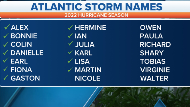
Atlantic basin hurricane names for 2022
(FOX Weather)