Tropical Storm Gabrielle set to become hurricane, could rapidly intensify to near major-hurricane strength
Gabrielle is expected to become a hurricane on Sunday and could strengthen into at least a Category 2 hurricane by Monday morning. In its latest discussion, the National Hurricane Center said that Gabrielle could have maximum sustained winds of 110 mph by Monday night.

Gabrielle set to become hurricane as new area to watch emerges in Atlantic
Forecasters say Tropical Storm Gabrielle is still set to become a hurricane on Sunday as a new area to watch for possible tropical development emerges in the Atlantic. FOX Weather Meteorologist Jane Minar has the latest on Sept. 21, 2025.
As of Sunday at 5:00 PM ET, Gabrielle strengthened into the second hurricane of the 2025 season in the Atlantic. Continuous coverage of Hurricane Gabrielle has moved here.
MIAMI – Tropical Storm Gabrielle is still set to become the second hurricane of the Atlantic season on Sunday, and forecasters say it could rapidly intensify to near major-hurricane strength (Category 3 or higher) in the coming days.
According to the National Hurricane Center (NHC), rapid intensification occurs when a tropical cyclone's maximum sustained winds increase by at least 35 mph in a 24-hour period.
Gabrielle, which had been known as Invest 92L and then Tropical Depression Seven, formed last Wednesday after a weekslong lull in tropical activity as we continue through the latter half of the 2025 Atlantic hurricane season.

(FOX Weather)
The NHC said that the current tropical storm is expected to pass somewhere to the east of Bermuda on Monday, and dangerous swells generated by Gabrielle are expected to impact the island through at least the start of the new workweek.
As of the latest advisory from the NHC, Tropical Storm Gabrielle had maximum sustained winds of 65 mph with some higher gusts, and strengthening is expected to continue over the next few days.
Gabrielle is expected to become a hurricane on Sunday and could strengthen into at least a Category 2 hurricane by Monday morning. In its latest discussion, the NHC said that Gabrielle could have maximum sustained winds of 110 mph by Monday night. A Category 3 hurricane begins when maximum sustained winds reach at least 111 mph.
HOW ARE HURRICANES RATED? THE SAFFIR-SIMPSON HURRICANE WIND SCALE EXPLAINED

(FOX Weather)
Tropical Storm Gabrielle is currently located less than 400 miles southeast of Bermuda and is moving off to the northwest at 12 mph.
The NHC said that general motion could continue through Sunday night before a turn to the north on Monday and a faster northeastward to east-northeastward motion on Tuesday.
While landfall in Bermuda is looking less and less likely, residents and travelers should monitor forecasts for changes.
Swells generated by Tropical Storm Gabrielle are expected to reach the U.S. East Coast from North Carolina northward, as well as Atlantic Canada, starting later Sunday and lasting through early this week.
Those swells are expected to bring dangerous surf and life-threatening rip current conditions at local beaches.
DOWNLOAD THE FREE FOX WEATHER APP
NHC monitoring 2 additional areas to watch for development in Atlantic

(FOX Weather)
The NHC is now monitoring two areas to watch for possible tropical development over the next week in the eastern and central tropical Atlantic Basin.
The NHC said that a broad tropical wave is producing limited showers and thunderstorms well to the west-southwest of the Cabo Verde Islands off the coast of Africa.
The NHC said that although environmental conditions are not favorable for initial development, conditions should gradually become more favorable for development by the middle to end of the upcoming week.
The NHC said a tropical depression could form as the system moves west-northwestward to northwestward across the central Atlantic.
The system currently has a medium chance of development over the next week.
(FOX Weather)
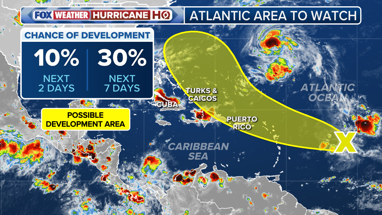
Another area to watch has also popped up more than 500 miles to the east of the Windward Islands.
The NHC said the system is producing a small area of disorganized showers and thunderstorms as it moves quickly westward.
According to satellite data, the system doesn’t have a closed circulation.
"Environmental conditions appear only marginally conducive for further development over the next several days while the system continues to move quickly westward to west-northwestward at around 20 mph," the NHC said.
By the end of this upcoming week, the system is expected to slow down and turn to the northwest to the north of Hispaniola.
"Regardless of development, the system is expected to bring gusty winds and showers to portions of the Leeward Islands on Tuesday," the NHC said.
The system currently has a low chance of development over the next week.