Tropical Storm Franklin to shoot the gap between US and Bermuda but dangerous rip current threat remains
The storm is expected to reach minimal hurricane status this weekend then perhaps major hurricane status by early next week, but safely pass between Bermuda and the U.S.

Franklin expected to reach Category 3 strength by Tuesday
Tropical Storm Franklin remains a tropical troublemaker in the Atlantic Ocean with increased swells and rip currents expected to impact East Coast beaches next week.
Note: As of Saturday 11:00 AM, Franklin strengthened into a hurricane. Continuous coverage has moved here.
Tropical Storm Franklin is slowly strengthening as it remains a tropical troublemaker in the Atlantic Ocean, with increased swells and rip currents expected to impact East Coast beaches next week.
The storm is expected to reach minimal hurricane status this weekend then perhaps major hurricane status by early next week, but safely pass between Bermuda and the U.S.
The FOX Forecast Center says the Southeast and mid-Atlantic coasts could experience big swells and hazards through the Labor Day weekend, but the forecast remains that the storm will not make landfall in the U.S.
NEW AREA OF INTEREST HIGHLIGHTED IN CARIBBEAN SEA AS PEAK OF ATLANTIC HURRICANE SEASON NEARS
Where is Tropical Storm Franklin now?
Tropical Storm Franklin is located about 660 miles south of Bermuda and moving east-northeast at 6 mph. It has maximum sustained winds of 65 mph. Tropical storm-force winds extend out up to 115 miles.

(FOX Weather)
Where is Franklin headed?
Franklin is not forecast to make landfall in the U.S. The track from the NHC shows the strengthening storm moving between the East Coast and Bermuda early next week.
A sharp turn toward the north, with an increase in forward motion, is expected on Saturday, with a northward or north-northwestward motion over the western Atlantic continuing through early next week.
GUIDE FOR 2023 ATLANTIC HURRICANE SEASON

(FOX Weather)
Will the US be affected by Franklin?
While Franklin is not expected to hit the U.S. mainland, big swells are expected to impact the Eastern Seaboard starting as early as Monday and lingering through Labor Day weekend, the FOX Forecast Center said. In addition, dangerous rip currents are forecast for beaches up and down the East Coast through the upcoming work week.
"This is not going to be a landfall for us," said FOX Weather meteorologist Britta Merwin. "We have a series of troughs coming off the East Coast and that’s going to be our protector. You don’t have to worry about this making landfall on the East Coast, but we could see some rough surf conditions."
NEAR-AVERAGE 2023 ATLANTIC HURRICANE SEASON EXPECTED WITH UP TO 17 NAMED STORMS, NOAA SAYS

(FOX Weather)
By next Wednesday morning, waves off the coast of North Carolina could be 9 to 12 feet, Merwin adds.
"Thankfully, the strongest waves and the biggest waves are going to be out of here by the time we get to Labor Day weekend," she said. "But if we have this pass too close, and we have some beach erosion ahead of the Labor Day weekend holiday, we could see some minor implications there."
BEWARE THE ‘I’ STORM: IT HAS MORE RETIREES THAN ANY LETTER USED FOR ATLANTIC HURRICANE NAMES

Rip currents could be big problem for East Coast as Franklin swirls far from shore
Tropical Storm Franklin won't be making landfall in the U.S., but it will still have impacts on the country. Brandy Campbell reports from Florida.
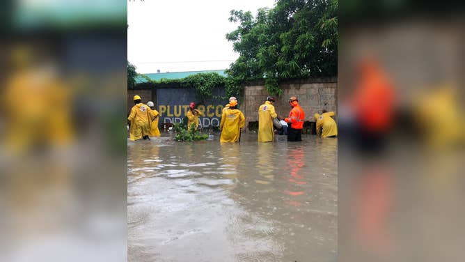
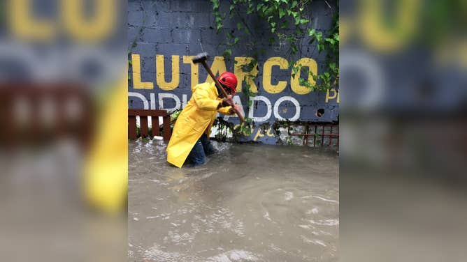
Franklin caused deadly flooding in Dominican Republic
The Dominican Republic has been hit hard by deadly floods and landslides caused by the heavy rainfall brought on by Franklin.
One person has died due to flooding in Santo Domingo, with two more missing and hundreds evacuated from their homes. At least six mountain communities experienced tree and power line damage.
![]() Image 1 of 10
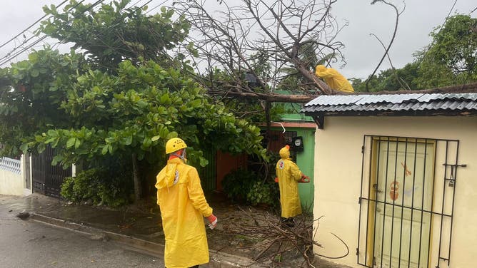
Image 1 of 10The heavy rainfall brought by Tropical Storm Franklin has caused deadly floods and landslides in the Dominican Republic. (Defensa Civil Dominicana)
![]() Image 2 of 10
Image 2 of 10Crews evacuating an elderly person from the waterfront. (Defensa Civil Dominicana)
![]() Image 3 of 10
Image 3 of 10The heavy rainfall brought by Tropical Storm Franklin has caused deadly floods and landslides in the Dominican Republic. (Defensa Civil Dominicana)
![]() Image 4 of 10
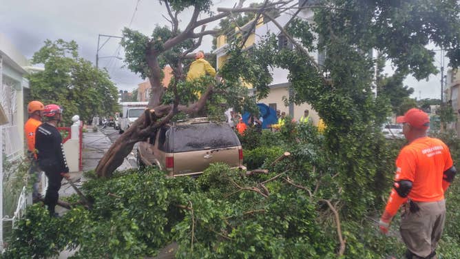
Image 4 of 10Harold's winds knocked a tree into a car. (Defensa Civil Dominicana)
![]() Image 5 of 10
Image 5 of 10The heavy rainfall brought by Tropical Storm Franklin has caused deadly floods and landslides in the Dominican Republic. (Defensa Civil Dominicana)
![]() Image 6 of 10
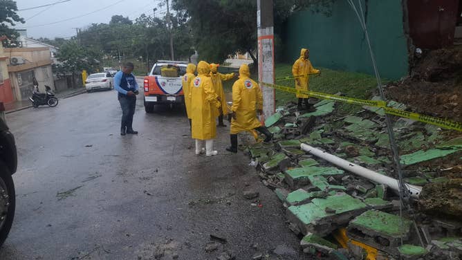
Image 6 of 10A retaining wall collapsed, succumbing to the force of saturated soil and wind. (Defensa Civil Dominicana)
![]() Image 7 of 10
Image 7 of 10The heavy rainfall brought by Tropical Storm Franklin has caused deadly floods and landslides in the Dominican Republic. (Defensa Civil Dominicana)
![]() Image 8 of 10
Image 8 of 10The heavy rainfall brought by Tropical Storm Franklin has caused deadly floods and landslides in the Dominican Republic. (Defensa Civil Dominicana)
![]() Image 9 of 10
Image 9 of 10The heavy rainfall brought by Tropical Storm Franklin has caused deadly floods and landslides in the Dominican Republic. (Defensa Civil Dominicana)
![]() Image 10 of 10
Image 10 of 10A first responder had to knock a hole in a wall lining a flooded road to drain. (Defensa Civil Dominicana)