Invest 92L near Africa, new disturbance 93L in Gulf of Mexico monitored for tropical development this week
If Invest 92L earns a name, it will be known as Sean. So far, 18 storms have reached at least tropical-storm status during 2023, which is above average.
Invest 92L near Africa, new disturbance 93L in Gulf of Mexico monitored for tropical development
As the Atlantic hurricane season enters the home stretch, the National Hurricane Center is monitoring a disturbance off Africa that has been given a high chance of development this week. Meanwhile, a new disturbance in the Gulf of Mexico has also caught the attention of forecasters.
As the Atlantic hurricane season is in its home stretch, the National Hurricane Center (NHC) is monitoring a pair of tropical disturbances – one off Africa that has been given a high chance of development this week and a tropical disturbance in the Gulf of Mexico that has also caught the attention of forecasters.
Here's the latest on the two disturbances, which have both been given "invest" status by the NHC.
WHAT IS AN INVEST DURING HURRICANE SEASON?

(FOX Weather)
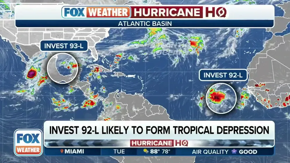
Invest 92L near Africa
The NHC says a tropical disturbance several hundred miles southwest of the Cabo Verde Islands continues to produce a large area of showers and thunderstorms over the eastern tropical Atlantic.
This disturbance has been dubbed Invest 92L by the NHC, which is simply a naming convention that allows forecasters to run specialized computer models on an area they are monitoring for development.

(FOX Weather)
Invest 92L has shown some signs of organization in recent days, the NHC said. Environmental conditions appear conducive for additional development, and a tropical depression is likely to form during the next couple of days while the system moves west-northwestward or northwestward across the eastern and central tropical Atlantic.
Invest 92L is at a low latitude, which helps give the disturbance higher odds of taking advantage of environmental conditions to develop into a tropical depression or tropical storm. If Invest 92L earns a name, it will be known as Sean.
So far, 18 storms have reached at least tropical-storm status during 2023, which is above average.
Invest 93L in southwestern Gulf of Mexico
A small low-pressure system over the southwestern Gulf of Mexico continues to produce an area of disorganized showers and thunderstorms. While environmental conditions appear only marginally favorable, the NHC said the system has a short window to develop further over the next day or so.
As of the latest NHC outlook, there is a low chance that a tropical depression could form within the next two days. However, the system will merge with a cold front over the western Gulf of Mexico by Wednesday morning, likely ending its opportunity for development.
GULF OF MEXICO TROPICAL DISTURBANCE TO SOAK DROUGHT-STRICKEN SOUTHEAST REGARDLESS OF DEVELOPMENT

(FOX Weather)
Regardless of whether it's tropical or non-tropical, the system is forecast to bring heavy downpours to the U.S. Gulf Coast, a parched region in desperate need of rain.
On Tuesday afternoon, the National Weather Service in Memphis said preliminary data shows the Mississippi River in the city hit an all-time record low stage of -11.01 feet.
The FOX Forecast Center is predicting between 3 and 5 inches of rain will fall from New Orleans to Tampa, Florida, over the next week. Heavy rain could lead to isolated flash flooding across the region.
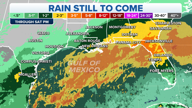
The rain outlook for the Gulf Coast states through this week.
(FOX Weather)
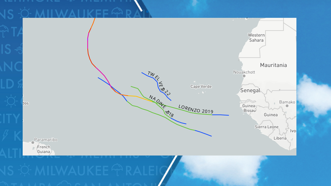
Disturbances in eastern Atlantic during October are rare to develop that far south
Tracking a disturbance in the eastern Atlantic, such as Invest 92L, during October is not rare, but how quickly the system forms into a tropical depression or storm could put the system in a class of its own.
WHAT TO EXPECT IN TROPICS AS HURRICANE SEASON ENTERS OCTOBER
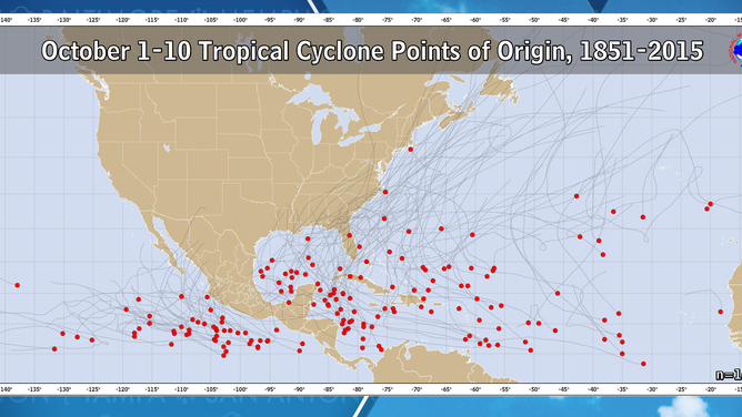
According to historical data from the NHC, most tropical cyclones that develop during the first 10 days of October don’t become either a tropical depression or storm until they reach at least 30 degrees longitude.
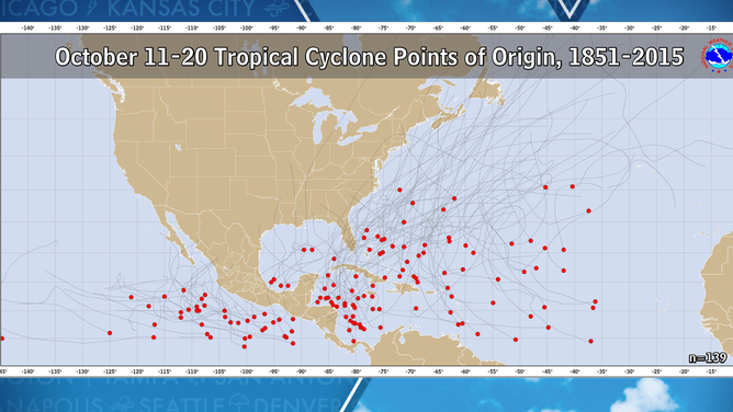
During the historical period from Oct. 11-20, the farthest east development typically happens is west of 35 degrees longitude.
The FOX Forecast Center said patches of dry air and cooler water temperatures usually grow during October, reducing the chances of development in the eastern Atlantic.
![Tropical development points of origin in October]() Image 1 of 2
Image 1 of 2Tropical development points of origin from October 1 through October 10. ( )
![Tropical development points of origin October]() Image 2 of 2
Image 2 of 2Tropical development points of origin from October 11 through October 20. ( )
Regardless of whether the disturbance develops, forecast models are unanimous in showing that it will not be a threat to any landmasses and harmlessly travel through the open water of the Atlantic.
7 WEATHER CHANGES TO EXPECT IN OCTOBER
The Atlantic Basin sees about one storm a year that develops around the Cabo Verde Islands in either the final days of September or in October.
In 2022, Tropical Depression Twelve developed on Oct. 4 southwest of the African islands but never strengthened into a named storm.
The last named storm to traverse the eastern Atlantic this late in the hurricane season was Victor in 2021. Victor organized into a tropical storm on Sept. 21 and dissipated by Oct. 5.
Late season development off the African coast since 2015