Moisture from Pacific tropical cyclones, frontal boundary to soak drought-stricken Gulf Coast
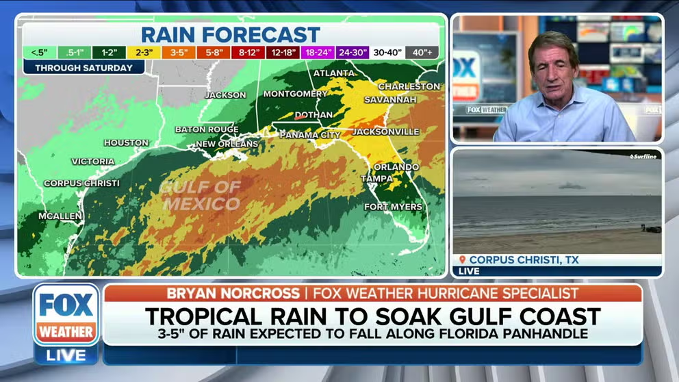
The systems will bring heavy tropical rain along the Gulf Coast. The FOX Forecast Center is predicting between 3 and 5 inches of rain will fall from New Orleans to the Tampa Bay area over the next week.
Hurricane Hunters investigate disturbance in Gulf of Mexico
The FOX Forecast Center says heavy rainfall is expected to fall along the Gulf Coast this week.
NEW ORLEANS – A developing storm system over the Gulf of Mexico, and moisture from Hurricane Lidia and former Tropical Storm Max in the eastern Pacific, will combine over the coming days to lead to heavy downpours along the U.S. Gulf Coast, a parched region in desperate need of rain.
The Hurricane Hunters investigated the disturbance on Tuesday, which was dubbed 93LL but found no signs of significant organization, leading the National Hurricane Center to drop chances of formation.
Despite the lack of development into tropical cyclone, the forecast doesn't change with heavy rainfall that is expected to continue along the Gulf Coast through the workweek.
WHAT IS AN INVEST DURING HURRICANE SEASON?

(FOX Weather)
The heavy rainfall is good news for Louisiana, Mississippi, Alabama and the Florida Panhandle and Big Bend that have been drought plaqued.
Southern Mississippi and nearly 60% of Louisiana are under exceptional drought, the most severe on the U.S. Drought Monitor scale.
The FOX Forecast Center is predicting between 3 and 5 inches of rain will fall from New Orleans to Tampa, Florida, over the rest of the workweek.

(FOX Weather)
Will the rain help the saltwater intrusion in Louisiana?
The drought in Louisiana is contributing to the saltwater intrusion happening in Plaquemines Parish and is forecast to impact parishes farther upriver in late October and into November. The low flow levels in the Mississippi River, because of drought, are not enough to keep the Gulf of Mexico seawater from moving upriver. As the saltwater wedge continues north, it has impacted at least two drinking water treatment facilities and is expected to cause problems farther upriver.
Areas including New Orleans, Galliano and Port Sulphur in southeastern Louisiana could see 1 to 3 inches of rain throughout the week. This includes the communities along the Mississippi River preparing for drinking-water impacts as the Gulf of Mexico salt water intrudes farther upriver.

(FOX Weather)
However, much of the rain that helps keep the Mississippi River flowing enough to keep the Gulf of Mexico at bay comes from the Midwest, which is also facing moderate to exceptional drought.
Normally, the Mississippi River holds off the Gulf of Mexico with a flow of about 300,000 cubic feet per second. The flow has been almost half that due to drought, according to the U.S. Army Corps of Engineers.
On Tuesday afternoon, the National Weather Service in Memphis said preliminary data shows the Mississippi River in the city hit an all-time record low stage of -11.01 feet.
Residents in Louisiana received good news last week as officials said the forecast had improved on the lower Mississippi River, delaying the salt water from the Gulf of Mexico moving farther upriver.
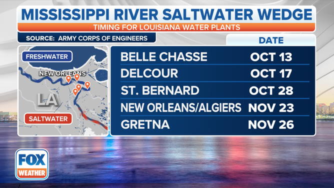
Saltwater intrusion timeline as of Oct. 5.
(FOX Weather)