Tropical Depression 4 expected to strengthen into Tropical Storm Cindy
Tropical Depression Four will remain well east of the northern Leeward Islands through the weekend before passing north of the Virgin Islands and Puerto Rico early next week.
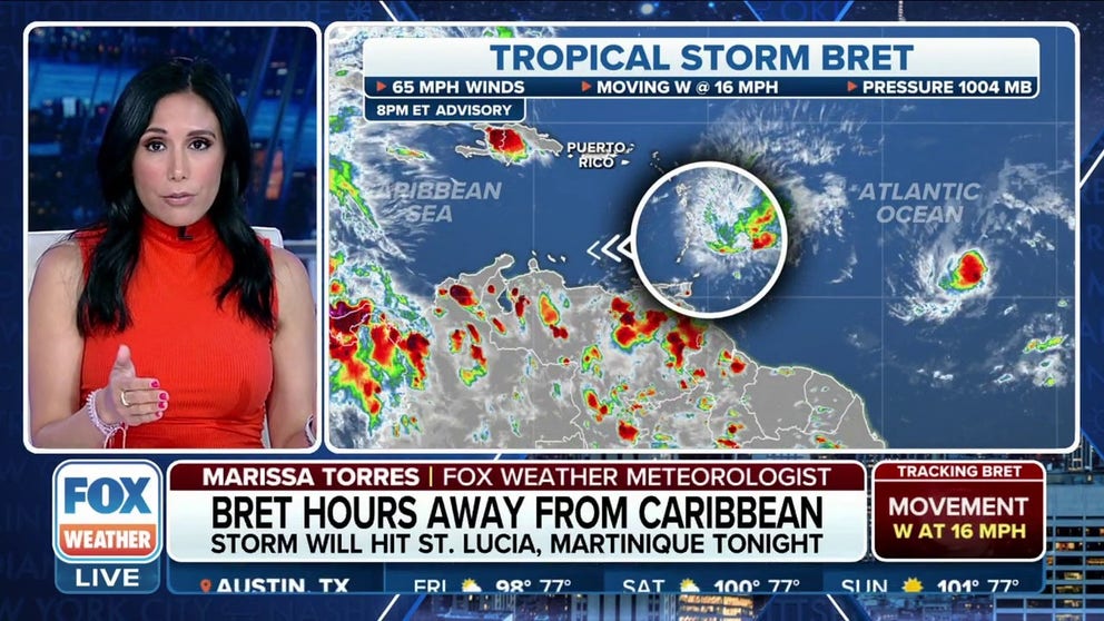
Tracking Tropical Storm Bret and Tropical Depression 4 as they move through the Atlantic Ocean
As of Thursday evening, Tropical Storm Bret was impacting islands in the eastern Caribbean. The cyclone was expected to dissipate over the weekend in the Caribbean Sea.
UPDATE 10:30 PM ET: Tropical Storm Cindy has formed in the Atlantic. Check here for the latest details on Tropical Storm Cindy.
What was named Invest 93L has strengthened into Tropical Depression Four over the central tropical Atlantic. It is following on the heels of Tropical Storm Bret, which developed earlier this week and is now closing in on the Caribbean islands.
This marks the first time in recorded history that two tropical cyclones have formed east of the Lesser Antilles during the month of June.
Where is Tropical Depression 4?
Tropical Depression Four is centered more than 1,100 miles east of the Lesser Antilles in the Caribbean.
As of late Thursday afternoon, the depression had maximum sustained winds of 35 mph.
HERE ARE THE BUZZWORDS YOU'LL BE HEARING DURING HURRICANE SEASON

(FOX Weather)
What is the forecast for Tropical Depression 4?
Tropical Depression Four is moving west-northwestward at 14 mph. It is expected to continue in this direction for the next few days. Eventually, it is expected to turn northeast.
On this forecast track, Tropical Depression Four will remain well east of the northern Leeward Islands through the weekend before passing north of the Virgin Islands and Puerto Rico early next week.
Some strengthening is predicted over the next few days, and the depression will likely become a tropical storm and earn the name Cindy.

(FOX Weather)
Tropical Depression Four is moving over waters that FOX Weather meteorologist Stephen Morgan called "freakishly warm." Warm water fuels tropical cyclones.
FOX Weather hurricane specialist Bryan Norcross noted that the warm waters and early tropical cyclone formation in this part of the Atlantic Ocean are unprecedented for this time of year, with tropical storms Arlene and Bret already roaming the Atlantic basin this month.
"We've never had a system that far east in June," Norcross said in reference to Tropical Storm Bret. "And this is at least significantly caused by the extremely warm water in the eastern part of the Atlantic this year. And not just in the tropical Atlantic, but all of the eastern Atlantic has really changed the weather pattern in this way that these systems can develop this early."
OFF THE CHARTS: OCEAN SURFACE TEMPERATURES REACH RECORD HIGH

(FOX Weather)
Hello, Cindy?
Once Tropical Depression Four's maximum sustained winds reach at least 39 mph, it will become Tropical Storm Cindy.
According to long-term averages from the National Hurricane Center (NHC), the season's first named storm doesn't typically form until June 20, the second named storm doesn't usually develop until July 17, and the third named storm doesn't tend to form until Aug. 3, so the Atlantic is off to a very fast start this year.
NO JUNE ON RECORD HAS HAD 2 STORMS FORM IN TROPICAL ATLANTIC WATERS EAST OF CARIBBEAN ISLANDS
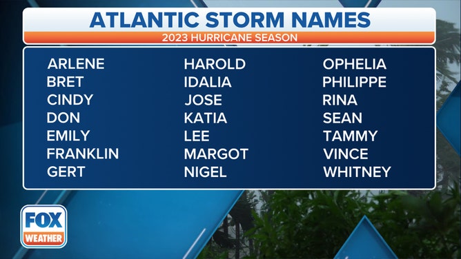
Here is the list of names for the 2023 Atlantic hurricane season.
(FOX Weather)
Tropical Depression Four formed on the heels of Tropical Storm Bret, which is swirling to this storm's west. Bret is threatening the Lesser Antilles in the Caribbean this week, though the latest forecast from the NHC indicates it is not expected to strengthen beyond a high-end tropical storm.
Hurricane season officially began on June 1. Arlene, the first named storm of the 2023 Atlantic hurricane season, formed on June 2.