Tropical Storm Philippe, Invest 91L duo complicate Atlantic forecasts as Caribbean islands monitor for impacts
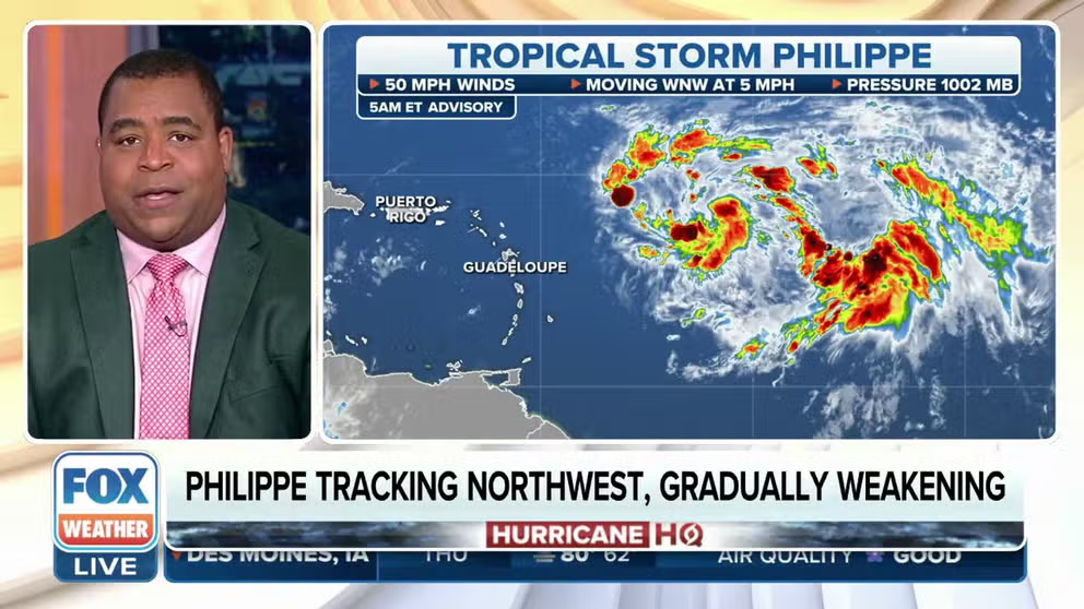
Tropical Storm Philippe has slowed to a near crawl just over 500 miles east of the northern Caribbean islands. Philippe's peak winds are still estimated at 50 mph, but it has reached its expected maximum intensity, according to the National Hurricane Center.
Tropics remain active in Atlantic as NHC monitors TS Philippe, Invest 91L
Tropical Storm Philippe is now just drifting some 500-plus miles east of the Lesser Antilles with Invest 91L close on Philippe's heels.
As of Thursday at 11:00 AM, Tropical Storm Rina formed in the Atlantic near Tropical Storm Philippe. Continuous coverage of Rina and Phillipe has moved here.
Tropical Storm Philippe continues to slowly stumble its way across the open waters of the Atlantic Ocean and could bring some rain and wind to the northern Caribbean islands and Puerto Rico over the weekend, while Invest 91L behind it continues to struggle to organize but still has high odds of becoming a tropical depression or storm.
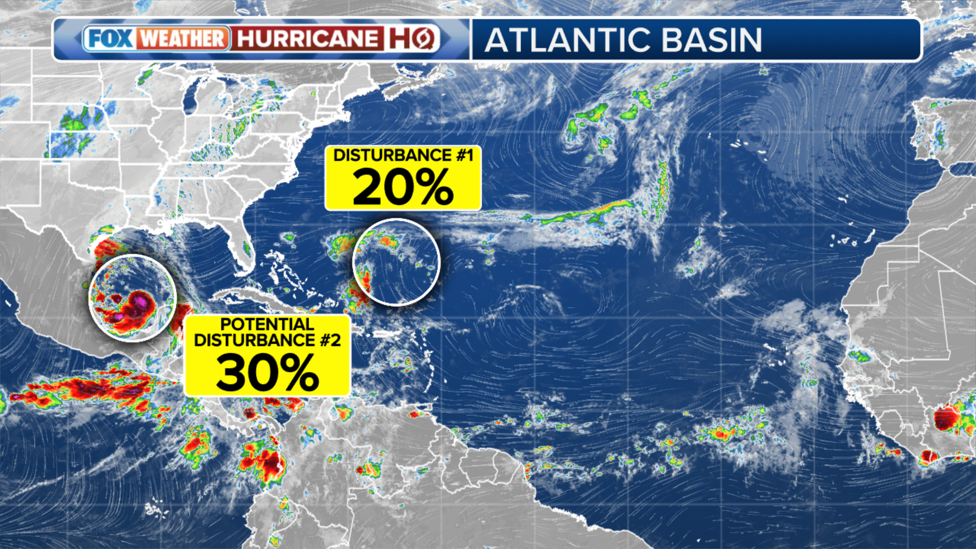
Here's a closer look at the active Atlantic Basin:
Tropical Storm Philippe

(FOX Weather)
Tropical Storm Philippe has slowed to a near crawl just over 500 miles east of the northern Caribbean islands. Philippe's peak winds are still estimated at 50 mph, but it has reached its expected maximum intensity, according to the National Hurricane Center (NHC). Computer forecast models show the system could degenerate into a remnant low as early as Sunday, though there is low confidence in how slowly Philippe will weaken.
Also of low confidence: Philippe's future track. There are several complex atmospheric factors in play that will influence Philippe's future, including the fate of Invest 91L churning just behind Philippe.
"The fact that these two systems are so close to each other means that their possible interaction has to be considered. Whichever system can find a conducive patch of atmosphere might well become dominant and control the path of the other," says FOX Weather Hurricane Specialist Bryan Norcross. "The phenomenon of two systems affecting each other is called the Fujiwhara Effect or a binary interaction. They can also interact without disrupting each other's track by simply creating more hostile wind flow around and over the twin system."
BRYAN NORCROSS: TROPICAL STORMS PHILIPPE AND LIKELY-RINA BATTLE FOR SUPREMACY IN ATLANTIC
As of Thursday morning, the forecast track and cone of Philippe has the storm drifting to the west-southwest over the next few days, followed by a turn back to the northwest early next week, which could bring Philippe or its remnants near the northern Caribbean islands. But the storm could also feel the tug of Invest 91L behind it, complicating the forecast for both storms.
However, Philippe could impact the northern Caribbean islands, the U.S. and British Virgin Islands and Puerto Rico with 1 to 3 inches of rain over the weekend and early next week. Heavy rainfall from Philippe may produce isolated urban and small stream flooding impacts.

(FOX Weather)
Philippe is the 16th named storm of the 2023 Atlantic hurricane season and the 17th system to reach tropical storm status.
Invest 91L in central tropical Atlantic
The National Hurricane Center continues to monitor a disturbance that is just to the southeast of Tropical Storm Philippe.
The disturbance has been dubbed Invest 91L by the NHC, but because of its proximity to Philippe, it has struggled to organize into a tropical depression or storm.
WHAT IS AN ‘INVEST’ DURING HURRICANE SEASON?

(FOX Weather)
Environmental conditions are expected to remain conducive for development, as long as 91L can stay far enough away from Philippe. If so, a tropical depression or tropical storm could form as soon as later Thursday or by Friday while the system moves northwestward across the central tropical Atlantic Ocean.
If the two storms get too close together, they may begin to interact and adjust their current forecast trajectories, depending on the strength of each system, the NHC says.
If 91L becomes a tropical storm with winds of at least 39 mph, this system will earn the name Rina.
(FOX Weather)