Bryan Norcross: Tropical Storms Philippe and likely-eventually-Rina battle for supremacy in Atlantic
Hot on Philippe's heels and located to its southeast is the Tropical Disturbance officially named Invest #91L. It is close to being organized and strong enough to be named Tropical Storm Rina.

FOX Weather is your Hurricane HQ, streaming free 24/7.
(FOX Weather)
Updated at 8 a.m. EDT Thursday
A super unusual battle is going on in the tropical Atlantic that makes forecasting the two systems' track and intensity a few days from now have wildly low confidence.
Tropical Storm Philippe is drifting in the general direction of the northeastern Caribbean islands. If the system or what's left of it makes it as far as the islands, it would happen late in the weekend or early next week. Hot on Philippe's heels and located to its southeast is the Tropical Disturbance officially named Invest #91L. It is close to being organized and strong enough to be named Tropical Storm Rina.
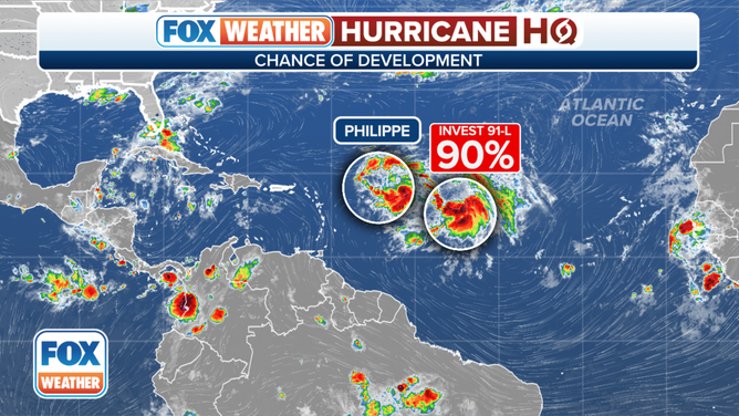
The tropical weather outlook for the Atlantic Ocean.
(FOX Weather)
The fact that these two systems are so close to each other means that their possible interaction has to be considered. Whichever system can find a conducive patch of atmosphere might well become dominant and control the path of the other. The phenomenon of two systems affecting each other is called the Fujiwhara effect or a binary interaction. They can also interact without disrupting each other's track by simply creating more hostile wind flow around and over the twin system.
And to start, both Philippe and the Tropical Disturbance are skating on the edge. The upper winds over both systems currently appear to be too hostile for them to strengthen very much. Yesterday, it looked like Philippe would be the most affected, but they both seem to be affected today. Philippe is plowing into increasingly dry air, while the disturbance is surrounded by a moister atmosphere, which Philippe left behind.
If two reasonably equal circulations come close, they will rotate around each other in a counterclockwise way. That means, if Philippe and probably-Rina interact, Philippe would be deflected south and probably-Rina north. If the two circulations are unequal, some amount of rotational deflection can happen, but the interaction can act to weaken or kill off the less robust system. Given the interaction between the systems and the somewhat hostile environment, both systems could also weaken.
Because the mutual intensities of the two systems are on a razor's edge, their tracks in the various computer forecast models are wildly divergent. In general, however, the forecast is for Philippe to be a weak system, perhaps just a remnant, when and if it's in the vicinity of the northeast Caribbean in the next few days.
It's also possible that Philippe will never get to the islands but will stall offshore and get pulled north along with Rina.
So the forecast for Puerto Rico and the surrounding islands is up in the air, to say the least. But it's possible that gusty squalls and periods of heavy rain from what's left of Philippe could impact the region. Likely-Rina has a better chance of heading north into the Atlantic.
The bottom line is that everybody in Puerto Rico and the surrounding islands of the northeast Caribbean needs to stay up to date on the latest forecasts over the weekend. With so much uncertainty in the track and strength of the nearby storms, extra vigilance is required.
Otherwise, the upper-air pattern is not conducive for tropical systems to develop even with the ultra-warm ocean-water temperatures from Africa to the Gulf. Although, the extra energy could help something spin up quickly if the right conditions come together. Stay informed.