Why the hurricane season will remain active into November
Vince and Whitney are the only unused names left on the list in the Atlantic for the 2023 season. The basin has already seen 20 storms and seven hurricanes.
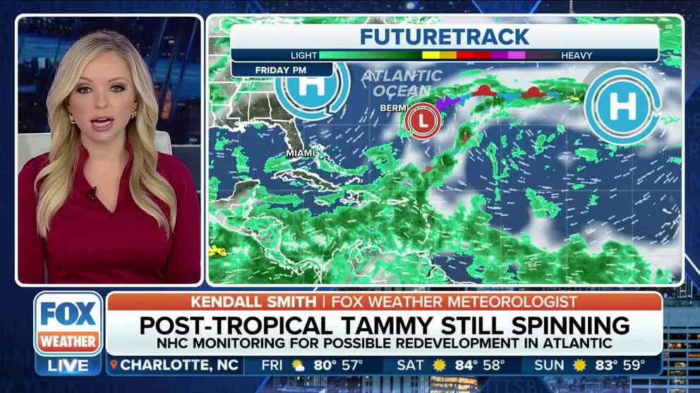
Tropics remain active during final week of October
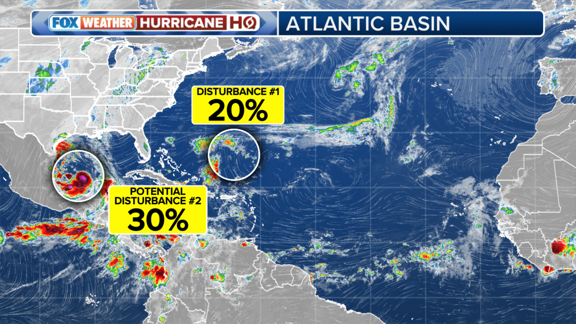
The National Hurricane Center is tracking four areas of disturbed weather in the Pacific and the Atlantic.
As October ends and November begins, what is typically a period of subdued tropical activity in the Atlantic and eastern Pacific is turning out to be anything but, with several areas of the basins being monitored for tropical cyclone activity.
During an average year, both regions produce at least one tropical cyclone each during November, but if atmospheric conditions are conducive, there could be several tropical storms and hurricanes to track.
The National Hurricane Center is currently monitoring four areas of disturbed weather in the Pacific and the Atlantic, with a region in the Caribbean receiving increased scrutiny due to the potential for land impacts.
During an El Niño year, water temperatures in the Atlantic basin tend to be cooler than average, and there is an increase in upper-level winds, but 2023 has acted anything but a typical year with increased activity reported in every ocean in the Northern Hemisphere.
(FOX Weather)
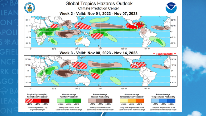
Heading into the last month of the season, the FOX Forecaster Center said conditions look generally favorable for tropical cyclone formation in the eastern Pacific and Caribbean as a broad area of low pressure develops.
This weather pattern is known as the Central American Gyre and can aid in the development of tropical cyclones in the Caribbean, the Gulf of Mexico and the eastern Pacific.
"There is good agreement among the dynamical models favoring an enhanced convective pattern tied to an emerging Central American Gyre (CAG) event over the tropical Americas. Combined with a decreasing shear environment predicted throughout the Caribbean, the broad scale circulation remains favorable for tropical cyclogenesis," NOAA forecasters recently stated during a tropical hazards outlook.
Due to the weather pattern’s complex nature, forecast models generally have a difficult time accurately predicting the formation of tropical cyclones from the gyre.
According to researchers at the National Weather Service’s Environmental Modeling Center, the Global Forecast System computer forecast model – commonly known as the GFS – is notorious for predicting the formation of tropical cyclones in the western Caribbean that never actually develop.
November hotspots
(FOX Weather)
HERE ARE THE BUZZWORDS YOU’LL BE HEARING DURING HURRICANE SEASON
Tropical Storm Amanda (2020), Tropical Storm Cristobal (2020), Hurricane Michael (2018), Tropical Storm Andrea (2013) and Hurricane Ida (2009) are all examples of recent areas of disturbed weather that formed off a Central American Gyre.
Hurricane Michael struck the Florida Panhandle as a Category 5 hurricane in October 2018 after spending a week embedded in the overall gyre off the coast of countries that make up Central America.
The years 2020, 2005, 2001, 1966, 1961 and 1931 had the most development across the basin during November, with at least three tropical cyclone formations during each season.
All the active seasons were either dominated by La Niña or neutral conditions, meaning that if November 2023 ends up busier than normal, the season will continue to set records.
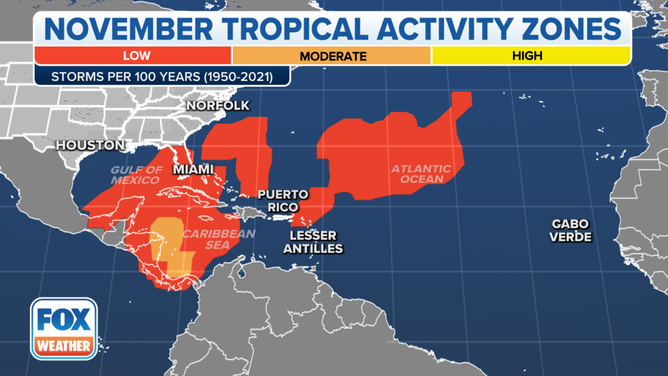
This map shows where tropical cyclone activity tends to occur during November. The data are shown as the combined number of tropical depressions, tropical storms and hurricanes whose centers pass within 125 miles of a point on the map during a 100-year period. The analysis is based on data from the 72-year period from 1950 to 2021 but normalized to 100 years.
(FOX Weather)