What is a Central American Gyre?
Central American Gyres can aid in the development of tropical cyclones in the Caribbean, the Gulf of Mexico and the eastern Pacific.

What to do when hurricane or tropical storm watches, warnings are issued for your town
What to do when hurricane or tropical storm watches, warnings are issued for your town.
Nearly every hurricane season, the FOX Forecast Center monitors a broad area of low pressure in the western Caribbean Sea and eastern Pacific Ocean, known as a gyre.
Due to its location, the circulation is known as the Central American Gyre and usually occurs during the rainy season from May through November.
Impacts expand outwards several hundred miles and lead to threats of torrential rainfall, flooding and mudslides for more than a dozen countries centered in and around Central America.
It is not uncommon to see numerous inches of rain as the pattern can exist for several days.
According to a 2017 study published in the Bulletin of the American Meteorological Society, the higher terrain in combination with nearby waterways, likely to play a significant role in the event’s formation.
7 FACTS TO KNOW ABOUT HURRICANES

A general overview of the Central American Gyre and its typical impacts.
(FOX Weather)
In some occasions, energy associated with the gyre can produce a tropical disturbance, if water temperatures and upper-level winds are conducive for development.
Due to the weather pattern’s complex nature, forecast models generally have a difficult time accurately predicting the formation of tropical cyclones from the Central American Gyre.
According to researchers at the National Weather Service’s Environmental Modeling Center, the Global Forecast System computer forecast model – commonly known as the GFS – is notorious for predicting the formation of tropical cyclones in the western Caribbean that never actually develop.
The FOX Forecast Center said sometimes slugs of moisture have a difficult time breaking apart from the main circulation and therefore are never able to form into a cyclone.
Both the early and late months of the hurricane season are more notorious for actually seeing a tropical disturbance break away from Central America and form into a tropical entity in either the eastern Pacific, Bay of Campeche or western Caribbean Sea.
HERE ARE THE BUZZWORDS YOU’LL BE HEARING DURING HURRICANE SEASON
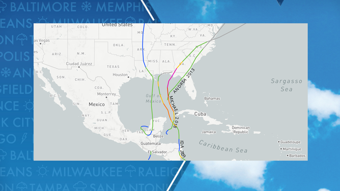
Previous tropical cyclones have formed from the Central American Gyre
On average, about once every other year, the Central American Gyre produces a tropical cyclone, with some that develop into full-fledged hurricanes if conditions allow.
Due to their formation hotspots in the Caribbean or regions in the southern Gulf of Mexico, many go on to threaten the Southeast coast.
Tropical Storm Amanda (2020), Tropical Storm Cristobal (2020), Hurricane Michael (2018), Tropical Storm Andrea (2013) and Hurricane Ida (2009) are all examples of areas of disturbed weather that formed off the Central American Gyre.
Hurricane Michael struck the Florida Panhandle as a Category 5 hurricane in 2018 after spending a week embedded in the overall gyre off the coast of Central America.
Usually, due to their formations in the early or late seasons, cyclones directly influenced by the Central American Gyre tend to be weaker when impacting the U.S. due to the prevalence of inhibiting factors such as cooler water temperatures and hostile upper-level winds.
Central American Gyre-influenced cyclones