Central American Gyre poses dangerous flood threat, but odds of tropical development are low
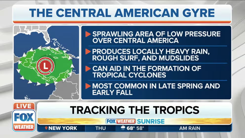
Central American Gyres can aid in the development of tropical cyclones in the Caribbean, the Gulf of Mexico and the Eastern Pacific
Central American Gyre poses dangerous flood threat for Central America
Central American Gyres can aid in the development of tropical cyclones in the Caribbean, the Gulf of Mexico and the Eastern Pacific.
A sprawling area of low pressure called a Central American Gyre is expected to develop in the days ahead over Central America, where it will pose a dangerous flood threat through early next week, while it might also try to generate a tropical depression or tropical storm in the Caribbean Sea.
The odds of tropical development are currently low due to a couple of inhibiting factors, but Central American Gyres can aid in the development of tropical cyclones in the Caribbean, the Gulf of Mexico and the Eastern Pacific.
According to research by Philippe Papin, a hurricane specialist at the National Hurricane Center, there is a peak in Central American Gyre occurrence between May and June and again between September and November, though they can form at any time during that seven-month period known as the region's rainy season.
HOW TO WATCH FOX WEATHER ON TV

A general overview of the Central American Gyre and its typical impacts.
(FOX Weather)
The Global Forecast System computer forecast model – better known as the GFS – was previously hinting that a tropical depression or tropical storm might form on the eastern side of the Central American Gyre, over the western Caribbean Sea, next week before the official start of the Atlantic hurricane season on June 1, potentially continuing a seven-year streak of early starts to the season.
However, the latest runs of the GFS model on Wednesday no longer suggest this tropical development will happen.
WEATHER GEEK SPEAK: WHAT'S A EURO OR A GFS?
Research by Alicia Bentley, an atmospheric scientist and weather model evaluator at the National Weather Service's Environmental Modeling Center, found that the GFS will frequently predict the formation of a tropical cyclone in the western Caribbean that never actually develops.
Additionally, a couple of inhibiting factors are present to keep the odds of tropical development at bay.
As of Wednesday morning, wind shear – the change in wind speed and/or direction with height – was strong across the northwestern Caribbean Sea and the Gulf of Mexico. Strong wind shear creates a hostile environment for the formation of tropical storms and hurricanes.
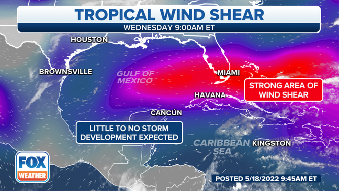
Strong wind shear was present across the northwestern Caribbean Sea and the Gulf of Mexico as of Wednesday morning, May 18, 2022.
(FOX Weather)
Further hampering the tropical development odds, the first Saharan dust plume of the 2022 season has emerged off the coast of western Africa and will be transported toward the Caribbean and the Gulf of Mexico into this weekend.
According to NOAA, this layer of dry, dusty air has been shown to suppress tropical cyclone formation and intensification in the Atlantic Basin.
FIRST SAHARAN DUST PLUME OF SEASON ROLLING OFF AFRICA WILL REACH U.S. BY THIS WEEKEND
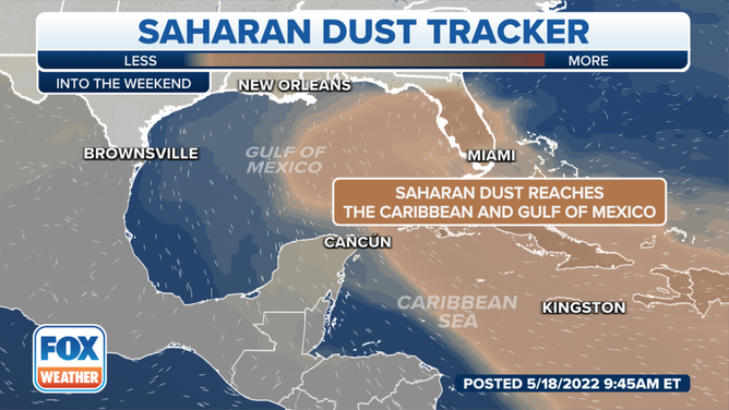
A Saharan dust plume will be transported toward the Caribbean and the Gulf of Mexico into this weekend.
(FOX Weather)
So, for now, the tropics are expected to remain quiet in the Caribbean Sea despite the presence of the Central American Gyre.
Dangerous flood threat in Central America
Papin noted in his research that Central American Gyres can produce torrential rainfall capable of catastrophic flooding.
Multiple days of extreme rainfall associated with these gyres are most common along the coastlines of Central America and within about 700 miles of the low-pressure system's center.
That will likely be the case with this Central American Gyre as it pulls in deep, tropical moisture over a large area between Panama and southeastern Mexico.
Some areas in Central America could receive more than 6 inches of rain through early next week, with locally higher amounts expected in the windward-facing mountains of the region.
Life-threatening flash flooding and mudslides might become a serious concern because of these tremendous amounts of rain.
WATER FROM HURRICANES, TROPICAL STORMS KILLS MORE IN U.S. THAN WIND
Some tropical moisture could eventually spread into parts of the U.S. Gulf Coast next week, increasing the threat of rain in those areas.
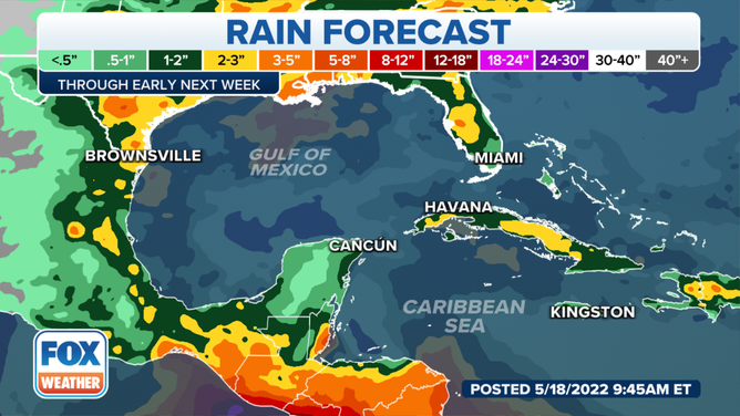
Rainfall forecast in Central America, Mexico and the U.S. Gulf Coast through early next week.
(FOX Weather)
CLICK HERE TO GET THE FOX WEATHER UPDATE PODCAST
Be sure to download the FOX Weather app for the latest forecast and weather alerts for your exact location, plus the 24/7 livestream of America’s Weather Team.